Descripción
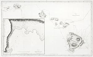
The first map of the Hawaiian Islands from the official English edition of the accounts of Captain James Cook's third and final voyage of discovery. The map features the tracks of Cook's ships with an inset of Kararkooa Bay at lower left. Cook discovered the Hawaiian Island of Kauai (Atooi) on 19 January 1778, spending four days exploring and engaging with the natives of Waimea. He then sailed to Nihau on 30 January 1778, departing 2 February in search of the Northwest Passage. Cook returned to the Hawaiian Islands, sighting Maui (Mowee) on November 26 1778. Unable to land, he then sailed on and charted the island of Hawaii. At Kealakekua, on 17th January 1779 he received an enormous welcome by a flotilla of Hawaiian canoes. The Islanders, believing Cook was an incarnation of the God Lono, hosted a grand ceremony in his honour. Cook left February 4 1779, amidst increasing tension between natives and crew members. While proceeding along the Kohala coast, the ships encountered a gale. A damaged mast on the Resolution forced the ships to return immediately to Kealakekua for repairs. After tools were stolen from the Discovery, (the armourer's tongs and later a cutter). Cook went ashore on 14 February with nine marines and attempted to take Kalani`opu`u, a powerful Hawaiian Island chief, as hostage. A scuffle ensued between the Hawaiians and Cook's shore party resulting in the death of Cook and four marines. After the skirmish a truce was declared, communication was resumed and the damaged mast repaired. The British requested the return of Cook's remains, however only part of Cook's body was returned along with his personal effects. The Resolution and Discovery left Hawaii February 22 1779 under the command of Captain Charles Clerke and Captain James King. From Cook & King, A Voyage to the Pacific Ocean Undertaken by the Command of His Majesty, for Making Discoveries in the Northern Hemisphere. References: Suarez, T. Early Mapping of the Pacific. Singapore 2004 fig 146, p.151. Howgego, J. Encyclopedia of Exploration to 1800. Sydney 2011 B106. Fitzpatrick, G. The Early Mapping of Hawaii. Routledge 1987 pl.2. Hill, J. The Hill Collection of Pacific Voyages. San Diego 1974 361. p.121, . Collections: National Library Australia: Bib ID 3539641 Te Papa Museum of New Zealand: Registration NumberRB000261/080a Image Size: 465mm x 275mm (18.3" x 10.8"). Paper Size: 494mm x 307mm (19.4" x 12.1"). Condition: Expertly repaired tear lower right corner as often found, otherwise in good condition, with folds as issued. technique: Copper engraving. N° de ref. del artículo CK03E 3001049 PI HAWI
Contactar al vendedor
Denunciar este artículo
![]()
