Descripción
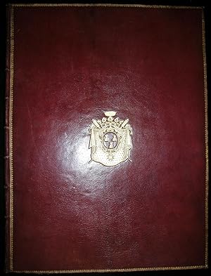
Folio (26 x 19 5/8 inches). The title-page and etched cartouche with the imprint of Chez Huquier, rue St. Jacques, of Paris, and initialled in the image "C.P.R." surrounding a calligraphic manuscript index ("possibly in Bellin's hand" - Sotheby's) laid down. 23 EXCEPTIONALLY FINE double-page engraved maps, the rhumb lines of one printed in olive green ink, of another two printed in sanguin, 2 full-page maps, for a total of 25 (of 29, lacking four maps) by Bourgoin le Jeune, Dheulland and others, all with original hand-colour in outline. A magnificent fine French binding of full contemporary red morocco, each cover decorated with elegant gilt borders and with the gilt arms of Jean Baptiste de Machault d'Arnouville, gilt inner dentelles, and the spine richly gilt in 8 compartments with 7 raised bands, with an olive green lettering-piece in one, all edges gilt. Provenance: with the gilt supra-libros of Jean Baptiste de Machault d'Arnouville (1701-1794); Christopher Henry Beaumont Pease, Lord Wardington (1924-2005), his sale, Sotheby's 18th October, 2005, lot 38. "This is probably one of the earliest collections of charts formed by Bellin after he had taken over the Marine Office and reprinted the Neptune François in 1753. The plates are by order of Monseigneur Le Comte de Maurepas, and his successor M. Rouillé, Chevalier Comte de Jouy, who in turn was succeeded by M. de Machault, around 1754, for whom this copy was bound" (Wardington Catalogue). Of the twenty-nine charts listed in the manuscript index it is doubtful whether six were ever present. These are numbers 5, 9, 14, 19, 22 and 23. Two maps have been added from other copies to replace maps 5 and 22 ("Carte reduite de l'Isle de la Jamaique" and "Carte reduite de l'ocean meridionale"). Maps that are relevant to America include the world map, a map of the North Sea showing the coast of Labrador, 2 maps of the Atlantic, the Pacific ocean, a map of the Gulf of Mexico, another of the the gulf of the St. Lawrence River, and 2 maps of the West Indies. There is also a fine map of the Philippines. Jacques Nicolas Bellin (1702-1772), the most significant and influential chart publisher in eighteenth-century France, was appointed chief cartographer and hydrographer to the French Navy in 1721. He was appointed "ingénier hydrographe" to the French navy's Dépôt des cartes et plans de la Marine in August 1741. Bellin was also a member of the Académie de Marine and of the Royal Society of London. During his 50-year career, Bellin published a number of atlases, including 'Hydrographie française' (1753), 'Carte de l'Amerique septentrionale' (1755), 'Petit Atlas Maritime' (1764), and 'Nouvelle méthode pour apprendre la géographie' (1769). His maps of the French territories in North America are considered particularly successful and valuable. Machault was nominated Controller of Finances in 1745, and introduced the "Tax de vingtieme", a levy of 5% on all income; it proved unpopular and he lost the support of Louis XV and Madame de Pompadour. In 1754 went on to become Minister of Marine, but in 1757 he was disgraced and retired to the country. From the distinguished library of Lord Wardington whose collection of Atlases was unique: "a panoply of the history of cartography and of great mapmakers" (Andrew Phillips "An Appreciation", Sotheby's sale catalogue). An attractive copy. Sabin 9141. Catalogued by Kate Hunter. N° de ref. del artículo 000106
Contactar al vendedor
Denunciar este artículo
![]()


