Descripción
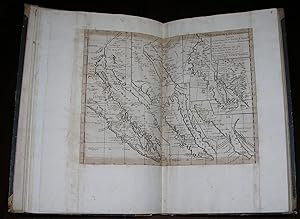
"Folio, (17 1/8 x 11 ¾ inches). Manuscript title page (a few pale stains). Fine folding engraved "Carte de la Province de Quito au Perou" by Pedro Vicente Maldonado (1704-1748); 54 engraved maps, some double-page, 9 with original hand-color in outline, trimmed to the neat lines with margins extended at the time of binding; 24 engraved illustrations (some browning; lower corner of leaf 68 torn, not affecting image). Contemporary quarter tan calf, paper-covered boards (hinges cracked but holding, generally worn). Provenance: Bookseller's ticket to verso of front free endpaper: Gustav E. Stech[ert], 810 Broadway, New York (partially torn away). Composite atlas with numerous maps, views, and illustrations of North and South American subjects, most dating from the 18th century. Maps are from a variety of sources, including Diderot's "Encyclopedie," "Histoire General des Voyages," and Robertson's "History of America," and were published by Jean Baptiste Bourguignon d'Anville (1697-1782), Rigobert Bonne (1727-1795), Jacques Nicolas Bellin (1703-1772), Robert de Vaugondy (1688-1766), and others. The earliest map is "Le Paraguay ou les RR PP de la Compagnie de Jesus ont répandu leurs Mission. Par le Sr. d'Anville" (1733). The latest map listed in the Table of Contents is "Cours du Mississipi comprenant la Louisiane, les deux Florides et une partie des états unis" by J. B. Poirson (1803); however, this map (on leaf 27) was at some point excised from the volume. The latest map present is "Nouvelle Carte des Parties Occidentales du Monde Servants a indiquier les Navigations Decouvertes et Establissements des Hollandois en Amerique" by Louis Genty (1787). Other maps include: "Carte du Mexique, ou de la Nouvelle Espagne ou l'on peut suivre les Mouvemens de Cortes…" from Robertson's History of America. Showing California ("New Albion"), the southwest, and Mexico, based on an earlier map by Thomas Kitchin. "Nouvelle Representation des Côtes Nord et Est de l'Asie," which consists of three maps side by side, each showing a theory of the Northeast Passage, contrasting the reports of three 18th Century cartographers. "Carte des Nouvelles Decouvertes dressée par Phil. Buache," the 1772 Vaugondy-Diderot map depicting Alaska, the Pacific Northwest, and the Northwest Passage. With two contrasting maps on one sheet, original drawn by Phillipe Buache to illustrate his theories regarding the northwest coast of America, and, more specifically, the possibility of a Northwest Passage. Below this is "Extrait d'une Carte Japonoise de l'Univers," a supposed re-creation of an early Japanese map discovered by Englebert Kaempfer and presented to Hans Sloane, President of the Royal Society of London. It shows a crude depiction of Asia, with Japan enlarged and a bit more accurate than the rest of the map. It also shows the Great Wall of China and Baja California, with the suggestion of a Northwest Passage. "Carte Generale des Decouvertes de l'Amiral de Fonte representant la grande probabilite d'un passage au Nord Ouest par Thomas Jeffreys," the Vaugondy-Diderot map of the northwestern coast of America and the northeastern coast of Asia, based on Jeffreys's map of 1768. "Improbably, a number of Russian expeditions to the northeast and east of the Kamchatka Peninsula of Siberia - notably by Vitus Bering in 1728-1741, when the Alaskan coast and the Aleutian Islands were sighted - added to, rather than lessened, the uncertainty as to the configuration of the coastline. In these circumstances, cartographers relapsed once more into fantasy. In 1747 Joseph Nicholas Delisle (1688-1768) returned to France after 20 years at the St. Petersburg Academy of Sciences, bringing with him maps and manuscript records of the Russian voyages. Three years later, he read a paper to the Academy of Sciences in Paris on the Russian discoveries, accompanied by maps drawn by his uncle, Phillipe Buache (1700-1773), the principal cartographer to Louis XV, which lent undeniable authority t". N° de ref. del artículo 72MMS162
Contactar al vendedor
Denunciar este artículo
![]()


