Descripción
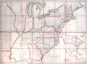
Fine folding engraved map, float-mounted and framed (framed dimensions: 38 x 52 inches), laid down on cartographical linen in 32 sections, with original hand-colour in outline and in part. Fourth edition, corrected to 1812, showing both Louisiana and Missouri Territory, established in 1812. The Mississippi River from the junction of the Ohio north to the Wyaconda River has been redrawn due to the public surveys in southern Illinois, exhibted by the addition of Township and Range lines. "Numerous other changes from the 1804 edition have been made throughout the map adding new counties, towns, roads, and changed physical features, primarily in the mid and western portions. Since it was a postal map and needed to be current as to towns, road and counties, it is probable that the map was updated every few years, until a new plate was made in 1819 by Harrison (Karpinski 59, Karrow 1-1466). The 1796 edition of this map (a different engraving) was changed four times in as many years (Wheat & Brun 127-130). The 1819 edition became the official post office map in 1825, used until 1829 (Ristow). All of the 1804 to 1812 editions were originally engraved by Francis Shallus of Philadelphia" (David Rumsey 2929001). Abraham Bradley, Jr.'s Map of the United States was a landmark production, arguably the first such detailed map produced by an American mapmaker and a visual testament to the growing expertise of the country's printers and cartographers after the triumph of the Revolution. An indigenous cartography sprang up and eventually flourished during the nineteenth century in response to nationalism, exploration, settlement, war, rising literacy, and finally, the exploitation of natural resources. Appointed a clerk in the American general post office in 1791 "Bradley's best known accomplishment was his authorship of a notable map of the United States, the first edition of which appeared in 1796, and the second in 1804, following the acquisition of the Louisiana territory. Bradley's maps were hung in many of the republic's post offices and were reprinted in Jedidiah Morse's American Universal Geography. Historians have agreed that the 1796 edition provides the best source of information about the geographical extent of the United States in the decade following the adoption of the federal Constitution. To a greater degree than almost any other single document published during this period, Bradley's maps helped to impress ordinary Americans with the size of the country and to transform the ill-defined frontier into a sharply etched border. "Bradley also coordinated the movement of the mail and took great pride in his almost encyclopedic knowledge of every single postal route in the country. Since most stagecoach firms relied on mail contracts to cover their costs, Bradley was thus largely responsible for the scheduling of passenger service throughout the United States. Though Bradley supported the subsidization of the stagecoach industry, he remained troubled by the potential for abuse. This was particularly true during the administration of Andrew Jackson; Bradley publicly denounced the Jacksonians for their "stage mania," by which he meant their lavish policy of subsidizing the industry with little regard to cost (John, p. 243). "To help keep expenses under control, Bradley personally supervised the payment of mail contractors, a challenging task. Because the United States lacked a single currency during this period, it was difficult to pay agents who lived at a great distance from Washington. To help overcome this problem, Bradley assumed the presidency of the Union Bank of Georgetown at some point prior to 1820. This made it possible for Bradley's signature to appear on the bank notes that the general post office disbursed. The fact that Bradley's signature was well known facilitated the transmission of postal revenue from the general post office to the contractors in the field" (Richard R. John for ANB). P-Maps p874; Ristow p70-1; Schwar. N° de ref. del artículo 1016mb1
Contactar al vendedor
Denunciar este artículo
![]()
