Descripción
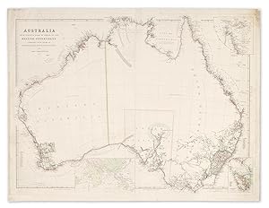
Arrowsmith's 1842 issue of this important large map of Australia, printed on two sheets and joined, recording the extent of settlement and the progress of inland exploration up to 1842. This map was issued in two different formats; 1. In the more often seen format, each sheet has a separate title ie: the title appears twice. 2. As our map in two sheets as in format 1, but with the title printed only on the western sheet (left). This version is much rarer. The map was the largest scale map of Australia available at that time. Arrowsmith derived much of his up to date information directly from explorers logs and the Colonial Secretary in London. WESTERN PORTION: Twenty-six counties are shown which are numbered and listed in table bottom left. The boundary between New South Wales and Western Australia shown at 129°E. The territorial limits of the Colony of Western Australia first formally defined by Letters patent dated 4th March 1831. Prior to that date the western boundary of New South Wales was by Letters patent of 6th July 1825, proclaimed at Sydney 20th Dec. 1825 extended to 129°E). The western boundary of South Australia is shown at 132°E declared on 28th December 1836. (McLelland, M. H. 1971, p. 672-3, 677) The tracks of the following explorers are shown; George Grey and Franklin Lushington Dec. 1837- April 1838, George Grey 1839, John Lort Stokes 1837-38, John Clements Wickham 1839, John Edward Eyre 1840, Wickham and Stokes April-Sept. 1840. In the 1840/1 state of the map Victoria is inserted on the Coburg Peninsula. Coburg Peninsula is now shortened to Coburg Pa. In this state of the map the Houtman Abrolhos Islands off the west coast have been redrawn and the individual island and passage names appear, i.e. North Is., Wallabi Is., Middle Passage, Easter Island, Zeewyk Passage. The Pelsaert Group named and South I. and Batavia Rd. named. South of these is Turtle Dove. This charting of the Abrolhos was performed by Wickham and Stokes from April 1st until May 23rd. 1840 (Hordern, Marsden 1989, pp 212-219 passim). On the opposite mainland coast Port Grey repositioned further north. Mt. Fairfax name repositioned. EASTERN PORTION: In the Northern Territory the Albert and Flinders Rivers, the Plains of Promise and Disaster Inlet are shown at the head of the Gulf of Carpentaria. These discoveries and namings resulted from the explorations of Captain Lort Stokes in the Beagle's boats during July and August of 1841. In South Australia the shape of L. Alexandrina has been changed. L. Albert, Malcolm and the Coorong appear on the south coast. References: Prescott 1842 Collections: National Library of Australia: Map Ra 112 Plate 59 State Library of NSW (Mitchell collection): Z/M2 804/1842/1 State Library of Victoria: Maps 804 A 1842 Arrowsmith Image Size: 870mm x 645mm (34.2" x 25.3"). Condition: Small repaired tears to sheet edges, some soiling mainly at top right, otherwise in good. Two sheets joined as issued. Technique: Copper engraving with original hand colouring. N° de ref. del artículo TLANG AM 1842 ARROW
Contactar al vendedor
Denunciar este artículo
![]()
