Descripción
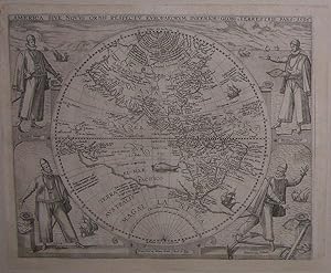
Single sheet, float-mounted and framed (sheet size: 14 x 16 6/8 inches; 12 6/8 x 15 4/8 inches to the neat line, full margins showing the plate mark; framed size: 23 x 27 inches). Fine engraved map of North and South America in a single western hemisphere, the title in a banner across the top edge, surrounded by an elaborate historiated border showing the great explorers of the New World: Columbus, Verspuci, Magellan, and Pizzaro, and decorated with galleons and a sea monster. INCORPORATING ACCURATELY FOR THE FIRST TIME THE WHITE - LE MOYNE CARTOGRAPHY UPON A MAP OF AMERICA (Burden). De Bry's map of North and South America, "America sive novus orbis respectu europaeorum inferior globi terrestris pars 1596", published in the sixth volume of his Great Voyages: "Americae pars sexta, sive historiae ab Hieronymo Benzono Mediolanese [sic]. scriptae, sectio tertia," being the concluding part of Benzoni's account of his fifteen years of travel in the Isthmus of Panama and Guatemala first published in Venice in 1565. "It was [written] at the time when the controversy concerning the treatment of the Indians was hottest, and a work, written by one who had just returned from the New World after a stay of fifteen years could not fail to attract attention. In writing it, no standard of criticism was applied; this was not in the spirit of the times. The ultra-philanthropists found Benzoni a welcome auxiliary, and foreign nations, all more or less leagued against Spain for the sake of supplanting its mastery of the Indies, eagerly adopted his extreme statements and sweeping accusations" (Catholic Encyclopedia). The map "is largely derived from the Petrus Plancius world map of 1594. [De Bry] clarifies the coastline of I:Dagoa in the Solomon Islands and interestingly calls the southern continent Magellanica. The information acquired by Cornelis Claez in 1594 from the Lasso chart is incorporated here in depicting a single insular Newfoundland. It incorporates accurately for the first time the White - le Moyne cartography upon a map of America, VIRGINIA being placed more correctly further south" (Burden 91). Inspired by a meeting with the celebrated Richard Hakluyt in London in 1587, Theodore de Bry published the first of his own collection of voyages relating to the Americas in 1590: Hariot's account of Virginia. In order to maximize profit he had editions published in English, Latin, French and German. He went on to publish five further parts before his death in 1598, when his sons Johann Theodor and Johann Israel took over the task of completing the Great Voyages and began the Small Voyages, and oeuvre which eventually stretched to 25 volumes. N° de ref. del artículo 72map284
Contactar al vendedor
Denunciar este artículo
![]()
