Artículos relacionados a Alaska, Laminated: Wall Maps U.S. (National Geographic...
Reseńa del editor
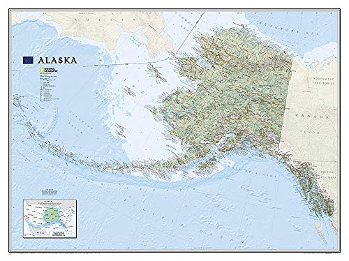
One of the largest and most detailed maps available for the North Star State. Rich shaded relief makes Alaska's incredibly diverse terrain easy to visualize and remarkably beautiful.
The map includes hundreds of named places including primary and secondary towns, political boundaries, infrastructure, hydrography, national parks, state parks, wilderness areas, major peaks, military reservations, and more. It shows Alaska in its entirety, including the entire 2,200 mile Aleutian Island chain that when mapping it in detail, cartographers almost always break it into sections for convenience. This map, however, portrays the entire State at the same scale on one wide sheet—offering an unparalleled perspective on Alaska's true size. Also found on the map is an inset map which displays Alaska's relative size to the conterminous U.S.
The map is encapsulated in heavy-duty 1.6 mil laminate which makes the paper much more durable and resistant to the swelling and shrinking caused by changes in humidity. Laminated maps can be framed without the need for glass, so the fames can be much lighter and less expensive.
- Map Scale = 1:3,660,000
- Sheet Size = 40.5" x 30.25"
Biografía del autor
Founded in 1915 as the Cartographic Group, the first division of National Geographic, National Geographic Maps has been responsible for illustrating the world around us through the art and science of mapmaking.Today, National Geographic Maps continues this mission by creating the world's best wall maps, recreation maps, atlases, and globes which inspire people to care about and explore their world.
"Sobre este título" puede pertenecer a otra edición de este libro.
- EditorialNational Geographic Maps
- Ańo de publicación2012
- ISBN 10 1597754110
- ISBN 13 9781597754118
- EncuadernaciónMapa
- Número de páginas1
Comprar nuevo
Ver este artículo
EUR 80,97
Gastos de envío:
EUR 11,90
De Reino Unido a Estados Unidos de America
Los mejores resultados en AbeBooks
Imagen de archivo
Alaska State Wall Map - (Laminated)
Publicado por
Natl Geographic Society Maps, 2013
ISBN 10: 1597754110
ISBN 13: 9781597754118
Nuevo
Paperback
Librería: Revaluation Books, Exeter, Reino Unido
Calificación del vendedor: 5 de 5 estrellas
![]()
Paperback. Condición: Brand New. lam map edition. 1 pages. 32.00x4.40x1.80 inches. In Stock. Nş de ref. del artículo: 1597754110
Gastos de envío:
EUR 11,90
De Reino Unido a Estados Unidos de America
Destinos, gastos y plazos de envío
Cantidad disponible: 1 disponibles