ArtĒculos relacionados a The Times World Wall Laminated Map (The Times Atlases)

Rese±a del editor:
BiografĒa del autor:
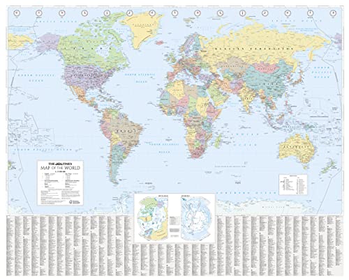
This laminated (front side only) Times Map of the World has been fully revised and updated to include the latest political changes. The map is politically coloured and shows individual countries and their capital city, major roads, railways and cities and towns.
Local name forms are used for all towns and cities with the English or historical alternative shown in brackets e.g. Mumbai (Bombay), Sankt Peterburg (Leningrad) where space permits. This makes the map readily accessible to the general reader who needs an up-to-date map to follow reports of world events in newspapers, on radio and television.
INCLUDES:
Ę All recent political changes carried out to mapping.
Ę Index to names on the map with cross references to alternative and historical name forms.
SIZE:
100 x 125 cm, 39.5 x 49 inches
AREA OF COVERAGE:
All of the world, centred on the Greenwich Meridian, and including maps of the North and South Pole regions.
SCALE:
Scale 1:25 000 000; 1 cm to 250 km; 1 inch to 395 miles.
Collins UKis a leading information-led publisher of illustrated and narrative nonfiction."
"Sobre este tĒtulo" puede pertenecer a otra edici¾n de este libro.
- EditorialTimes Books
- A±o de publicaci¾n2014
- ISBN 10 0007493126
- ISBN 13 9780007493128
- Encuadernaci¾nP¾ster
- N·mero de pßginas1
(Ning·n ejemplar disponible)
Buscar: Crear una petici¾nSi conoce el autor y el tĒtulo del libro pero no lo encuentra en IberLibro, nosotros podemos buscarlo por usted e informarle por e-mail en cuanto el libro estķ disponible en nuestras pßginas web.
Crear una petici¾n