ArtĒculos relacionados a Shipwrecks Of The Delmarva, Tubed: Wall Maps History...

Rese±a del editor:
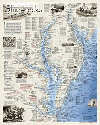
Shipwrecks of the Delmarva shows the location of more than 2,400 wrecks from the waters off the Delaware coast to the waters of the Chesapeake Bay, displayed atop beautiful bathymetric and coastal detail. Each wreck site is symbolized to define the class, type, and name of vessel accompanied by their dates of sinking. Locations of lifesaving stations, lighthouses and lightships, along with navigational beacons are accurately marked. Bathymetric and coastal features are clearly labeled, accompanied by inset maps, captions, and drawings used to highlight unique historical events such as the sinking of the U.S.S. Cumberland, the German U-Boat offensives, and the ghost fleet of Mallows Bay — the largest assemblage of wooden ships in the Western Hemisphere.
Wrecks featured on this map span from the mid-1600s galleons to 20th-century naval ships, those lost in military conflict, foul weather, bloody mutinies, pirate raids, human error, treacherous shoals, and a myriad of other events.
The map is packaged in a two inch diamater clear plastic tube. The tube has a decorative label showing a thumbnail of the map with dimensions and other pertinent information.
- Map Scale = 1:414,500
- Sheet Size = 28" x 35"
"Sobre este tĒtulo" puede pertenecer a otra edici¾n de este libro.
- EditorialNational Geographic Maps
- A±o de publicaci¾n2012
- ISBN 10 1597754188
- ISBN 13 9781597754187
- Encuadernaci¾nMapa
- N·mero de pßginas1
Los mejores resultados en AbeBooks

Imagen de archivo
Shipwrecks of the Delmarva (Tubed)
Publicado por
Natl Geographic Society Maps
(2010)
ISBN 10: 1597754188
ISBN 13: 9781597754187
Antiguo o usado
Cantidad disponible: 1
Librería:
Valoraci¾n
Descripci¾n Map. Condici¾n: Good. 1. N║ de ref. del artĒculo: SONG1597754188
Comprar usado
EUR 31,41
Convertir moneda