Descripción
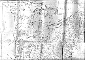
12mo (6 4/8 x 4 inches). Engraved title-page. Engraved folding frontispiece map of the United States (laid down on archival paper, stained and chipped with insignificant loss), and 18 folding maps of Connecticut, Delaware, Georgia, New Jersey, Kentucky, Maine, Maryland, Massachusetts, New Hampshire, New York, North Carolina, Pennsylvania, Rhode Island, South Carolina, Northwest Territory, Southwest Territory, Vermont and Virginia (edges a bit chipped, some offsetting, browning and staining, lacking the rear free endpaper). Contemporary sheep (extremities scuffed with some loss particularly to the foot of the spine). Provenance: Contemporary ownership inscription of Mr. Wm. McIntire, Baltimore, MD on the front paste-down. First edition of the first Gazetteer of the United States, with an early ownership inscription confirming the date of publication to be 1794 rather than 1795 as on the title-page. Philadelphia engraver and publisher Joseph T. Scott, along with fellow Philadelphian Mathew Carey, was one of the first American cartographic publishers: "The maps I have drawn and engraved myself, and I trust they will be found, on examination, as accurate as circumstances would admit, and probably more so than any collection of maps that has hitherto been published in the United States" (Scott "Preface"). Scott's gazetteer includes some of the most important early maps of the new "western" territories, as well as quite accurate depictions of the developing eastern states. Evans 29476; Sabin 78331; Howes S237. N° de ref. del artículo 001547
Contactar al vendedor
Denunciar este artículo
![]()
