Descripción
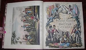
4to., (12 5/8 x 11 inches). Half-title, letterpress title page. Fine folding engraved "Plan of the Battles of Ligny, Quatre Bras, and Waterloo," printed in two colors and hand-colored in part; fine folding engraved "Map of the Country Between Brussels and Paris"; hand-colored engraved frontispiece and additional title page by George Cruikshank; fine folding hand-colored engraved plate "The Battle of Waterloo"; 25 hand-colored engraved plates, 3 laid down. Early 20th-century half burgundy morocco, the spine in six compartments, with five raised bands, gilt-lettered in one and the others with borders of gilt fillets and decorated with central gilt medallions; all edges gilt; by Riviere & Son (backstrip detaching; a bit rubbed). First edition. Beautifully illustrated with fresh and bright hand-colored aquatints. Illustrations include: "The city of Brussels, from the entrance of the Foret de Sogne, with the Barrier"; "Entrance to the Foret de Soigne, where the two roads from Brussels meet"; "Chapel of Waterloo"; "Headquarters of the Duke of Wellington, in the village of Waterloo"; "Skirt of the Foret de Soigne, with a distant view of the village of Mont St. Jean"; "Part of the village of Mont St. Jean"; "View of the cottage of Valette"; "Chateau of Frischermont"; "The farm of La Haye Sainte"; "La Belle Alliance, the centre of the French position"; "The village of Genappe"; "Ligny Castle"; "The Battle of Waterloo." Tooley 336. Abbey, Life 372. Cohn, Cruikshank, 580. N° de ref. del artículo 72MMS128
Contactar al vendedor
Denunciar este artículo
![]()

