Descripción
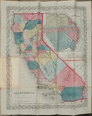
Single sheet, (17 ¼ x 13 ¼ inches). Publisher's Advertisement leaf mounted on inside front cover. Fine folding lithographed map with original hand color in full (some separation along folds, one or two spots). Original publisher's blindstamped red cloth gilt (a bit rubbed). Provenance: With library deaccession stamp of Union Theological Seminary Library to verso. With bookplate of American Bible Society (with stamp indicating deaccession). From the important cartographical library of Warren Heckrotte, his sale, Rare Cartography, Exploration and Voyages, Part II, December 3, 2015, Lot 119. First edition. With large inset of the City of San Francisco at upper right; 1853 census printed (or inkstamped?) on verso of map. First issue of J.H. Colton's little pocket map of California. Wheat notes that "This was probably the best-known map of California in the eastern states during the 'fifties. It was republished annually for a time, with little or no change." Warren Heckrotte describes various issues of the map in his notes: "This was reissued in 1854 as a separate, and also used to illustrate Capon's California. In 1855, it was copyrighted anew and was included in Colton's Atlas. The 1855 map was issued as a separate. The only difference I find between my 1853 issue and the 1854 issue in my copy of Capron, aside from different paper and some differences in color, is that at Nevada City, the 1853 issue has only 'Nevada'; the 1854 issue adds 'City.'" Mr. Heckrotte also states that "this map appears to be rare." Between 1831 and 1890, the Colton firm dominated American map publishing, and their atlases were the finest produced in the U.S. during the nineteenth century. The company was founded by Joseph Hutchins Colton (1800-1893), who had no formal training in geography or cartography; he began by purchasing copyrights of maps prepared by other individuals or companies, and his principal role was to manage the production and distribution of the maps. His first maps were drawn by the esteemed cartographer David H. Burr in the 1830s. By the 1850s Colton was also publishing guidebooks, atlases and immigrant and railroad maps. The firm was renamed G.W. & C.B. Colton in the 1860s when Colton was succeeded by his sons, George Woolworth Colton (1827-1901) and Charles B. Colton (c. 1831-1916). It is believed that George Colton compiled the company's 1855 Atlas of the World and served thereafter as the firm's principal map compiler, cartographer and engraver. The Colton firm refused to compromise quality, choosing to compete for sales in the more expensive international market rather than the cheap domestic one. For this reason, all maps were printed with steel plates, rather than as wax engravings, which was the most common method used at the time. OCLC/WorldCat locates eight copies of the map. Wheat Gold Region 238. Rumsey 2885. Streeter Sale 2734. N° de ref. del artículo 72MMS377
Contactar al vendedor
Denunciar este artículo
![]()
