Descripción
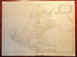
SANSON D'ABBEVILLE, Nicholas (1600-1667). Amerique Septentrionale Par N. Sanson d'Abbeville Geog. du Roy A Paris Chez l'Auteur Et chez Pierre Mariette rue S. Iacques a l Esperance 1650. Avec privilege du Roy pour vingt Ans Single sheet (17 x 22 6/8 inches; 15 2/8 x 22 6/8 inches to the neat line; full margins showing the plate mark). Engraved map of North and Central America, showing the northeastern and southern coasts and territories in close detail, particularly New France and the Great Lakes, all of which are shown here for the FIRST TIME, the west coast extends as far north as as California, which is shown as an island, and New Mexico; the title appears within a fine rococo cartouche upper right, with lines of latitude and longitude numbered every 5 degrees, all with fine original colour in outline, on paper watermarked with Grapes, similar to Heawood 2428 with word Colonbier around grapes (central vertical crease, a bit browned, corners chipped with loss) Provenance: with Alta California Books, 7/66; from the important cartographical library of Warren Heckrotte, his sale, Rare Cartography, Exploration and Voyages, Part I, 29th October, 2015, lot 176 First edition, third issue. There are three states of the map: the first state, of which only two examples are known, which has no land to the north-west of California; the second state, also quite uncommon, adds coastline to the north and west and eliminates a few place-names north of California; the third state is the same as the second, except that Lake Ontario has been shaded to match the other Great Lakes. Sanson's "Amerique Septentrionale" is the most influential map of North America of the 17th-century. On it for the first time on a printed map are depictions of all five of the Great Lakes. "LANDMARK MAP OF NORTH AMERICA" (Burden) "In 1650 Sanson published his LANDMARK MAP OF NORTH AMERICA. It was drawn, with his usual care, using the sinusoidal projection which is sometimes known by the name Sanson-Flamstead. It is, perhaps, most important for being the first printed map to delineate the five Great Lakes in a recognisable form. Sanson's map was the first to name Lakes Superior and Ontario, and Lakes Erie and Huron, unnamed, appear in a more familiar form. Montreal, recorded here at the important junction of the R des Prairies, Ottawa River, and the St. Lawrence River, was chosen by Champlain in 1611 as the site for a trading post, but it was not until 1642 that it became occupied year round. The waters of the north illustrate the continued hope of a North West Passage. The majority of the cartography of New France was new and would remain as the most accurate until seperseded by Coronelli in 1688. The east coast of North America does not bear much detail, but one interesting feature is the location of "Novelle Amsterdam" on an island some distance off shore. The reference to N. Suede is the first on a printed map of the Swedish colony founded in 1638. The south and south-east are largely similar to those of the Hondius, America Septentrionalis, 1636. "To the west S. Fe, Navajo, Apache, Taosij and others all appear for the first time. The first is incorrectly placed on the west bank of the Rio Grande, here again flowing to the south-west. These were the first advances in the geography of this region for some time. California as an island is of the Briggs type with some important alterations; Sanson introduces four placenames from the de Laet map of 1630, C. de Fortune, C. de Pinos, C. de S. Martin and C. de Galera" (Burden 294). Louis XIV, The sun King, King of France (1643 1715) had ruled his country and a large proportion of North America for a mere 7 years when Sanson created this magnificent map of his French Dominions there. His reign, principally from his great palace at Versailles, covered one of Frances most brilliant periods and Louis, the Sun King, remains the symbol of absolute monarchy of the classical age. However the beginning of his reign was fraught wi. N° de ref. del artículo 72map372
Contactar al vendedor
Denunciar este artículo
![]()
