Descripción
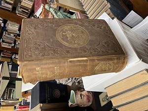
Two maps (one foldout), engravings including six full page plates with tissue guards, 9.5 x 6, blindstamped cloth with gilt decoration and lettering, 824 pp. Covers extremely well worn, rubbed, sunned, extremities worn, upper spine tip lacking, tears along side edges of spine, inner hinges cracked, bookplate removed, spotting, offsetting, text block in two pieces, detached signature, small tears, creased corners, folding map torn, illustration table lists the text illustr of Thomas O. Larkin twice (pages 95 and 758) but he only appears on one page else all called-for illustr are present. Well illustr, with some of the nicer engravings being done by J.W. Orr of New York, the most prominent engraver on the East Coast, among his many works was Harper's Illustrated Shakespeare. Book contains information on the geography of the area: floods, fires and earthquakes, mining, gambling, Chinese immigrants, real estate transactions, the female populations (virtuous and otherwise), hotel and restaurants and much more, a fun read. Howes 776. Sold as is -- no returns. FIRST ED. N° de ref. del artículo 98-3364
Contactar al vendedor
Denunciar este artículo
![]()


