Descripción
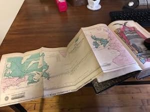
Fold-out "Map of the Submarine Telegraph Between America & Europe", 12/12 plates, decorative blindstamped leather, gilt dec and lettering, marbled edges and endpapers, (xi), 15-732pp. Covers worn and rubbed, spine detached, front inner hinge cracked, toning, scattered foxing else good to very good condition. Captain Ingraham plate is opposite p58 instead of p2. In the illustration list it is noted that an engraving of Captain Nathan Hale "Accompanies the book" but it is not present. Subject matter includes "American Temperance Reformers", "American Colony Of Liberia", "American Arctic Expedition". Also poems by Longfellow, Bryant, Whittier, Poe, Holmes. Map: "Map Of The Submarine Telegraph Between America & Europe." Korff Brothers, New York 1857. Oblong 19.5 x 8", light toning and foxing, fold creases else good to very good condition. "Printed For Howe's Adventures & Achievements of Americans". Hand colored lithograph. Not part of the plate list. This map, which has a few variants, shows the course of the cable initiating from Trinity Bay (St. John's Newfoundland in other examples) and the inset map of the harbor of St. John's Newfoundland (not always present in other examples). Very SCARCE and desirable map. This volume states 1858 which would make it a first edition with 732pp and that agrees with OCLC, however NUC indicates that this edition should have 720pp. Also, OCLC indicates a map, NUC does not, both vary on number of plates. Very SCARCE with map. N° de ref. del artículo 21-6375
Contactar al vendedor
Denunciar este artículo
![]()
