Descripción
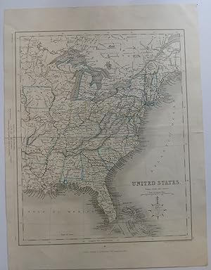
A single sheet from an atlas, folded as issued, measuring 9" x 11.25". This map shows the eastern United States, including portions of Canada and one tier of states west of the Mississippi River including a small portion of "Texas." Hand-colored outlines of states are in blue and yellow. It also shows "railroads already open" in addition to cities, towns and geographical features. Also mentioned are locations of Sioux, Fox, Chippewa and Algonquin Indian tribes in the Midwest and Great Lakes region. Michigan is represented in the style of maps from 1820's-1840's, but the two railroads in the state are shown as completed and the state is correctly configured with the upper peninsula as well as the Ohio boundary (the Upper Peninsula is designated "Part of Michigan"). The capitol of Arkansas is designated as the ficticious Arkopolis. There is no date on this map, and I can't locate it in Karpinsk, but it is obviously taken from an atlas. "Paris" in pencil on blank verso of map in an old, ornate hand. Along the edge of the map is a comparison of distances in the United States and Great Britain with an 1830 date. Drawn and engraved by J. Archer, Pentonville, London and Published by H. G. Collins (22 Paternoster Row, London). While this is undated, it is probably from an 1840's edition of one of Gilbert's Atlases. Ref: Phillip's Maps in the Library of Congress, p. 603 ; Handcolored map; 9" x 11.25". N° de ref. del artículo 14786
Contactar al vendedor
Denunciar este artículo
![]()
