Descripción
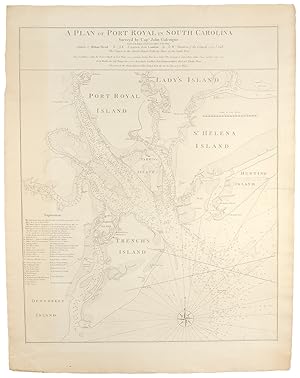
Copper-engraved sea chart, in excellent condition, on a full untrimmed sheet. A very rare and highly detailed sea chart, the most important map of South Carolina's Port Royal Sound and Hilton Head made in the early days of the Revolutionary War, in the first state. This very finely engraved and immensely detailed chart was superior to all other maps printed of the region, and the most important portrayal of the Port Royal Sound available in the early days of the Revolutionary War. The map embraces today's Beaufort County, with the Sound's excellent natural harbour, formed by the numerous Sea Islands, which are separated from each other by an elaborate web of tidal channels. The Broad River enters from the north, and the sound is bordered by Port Royal, Parris, and Trench's (Hilton Head) Island, and Lady's and Saint Helena Islands. In the upper-centre of the image is the town of Beaufort, and numerous plantations are individually labeled. This sea chart was one of the most detailed and accurate of any such map of the American coastline. The immense detail of the hydrography was the result of surveys conducted by Captain John Gascoigne, assisted by his brother James. In 1728, aboard the HMS Alborough, he employed the most sophisticated and modern techniques with exacting attention to detail to produce a manuscript chart. The next year, this chart was altered by Francis Swaine, and it would appear that Swaine's manuscript, or a close copy of it, found its way to the London workshop of William Faden. Faden, the successor to the great Thomas Jefferys, was already one of Britain's leading cartographers and this map, present here in the first state, although undated, was printed in 1776. The Port Royal Sound region has one of the most diverse and fascinating histories of any part of the American South. The region was originally the domain of the Yamasee native tribe, and was known to Europeans since 1521, when it was encountered by a Spanish expedition led by Francisco Cordillo. In 1562, Jean Ribaut led a party of Huguenot colonists to found Charlesfort on Parris Island. The French presence soon proved too close for comfort for the Spanish, who had established a base at St. Augustine in 1565. The Spanish commander, Pedro Ménendez de Avilés succeeded in crushing the French colony, establishing his own outpost of Santa Elena nearby in 1566. Santa Elena became the capital of Spanish Florida and an important Jesuit mission that sought to convert the natives to Christianity. It was finally abandoned in 1587. For a brief period in the 1680s, the area was also home to a Stuart Town, the first Scottish settlement in the Americas. In 1663, Captain William Hilton, sailing from the Barbados in the Adventure, conducted a reconnaissance of the region, newly claimed by England. It was on this trip that he named "Hilton Head" after himself. In the 1670s, the first governor of Carolina, William Sayle led a party of Bermudian colonists to found the town of Port Royal. The English settlement of the region proved to be successful and enduring, and what was to become the most important town in the region, Beaufort, was founded in 1710. This chart was the finest and most detailed map available in the early days of the Revolutionary War, and would most certainly have been used by commanders in formulating their battle plans. This is significant, as Port Royal Sound was one of the South's finest harbours, both sides in the conflict believed that possession of the area was of great strategic importance. Early in the war, the region had fallen under the control of the American patriots, however, in December, 1778 the British seized control of nearby Savannah, Georgia. As the new year of 1779 dawned, the British commander there, General Augustin Prevost was determined to further his gains. Taking advantage of Britain's naval superiority, Prevost dispatched the HMS George Germaine with 200 marines aboard, commanded by Major Valentine Gardiner. On February 1st, N° de ref. del artículo 19684
Contactar al vendedor
Denunciar este artículo
![]()
