Descripción
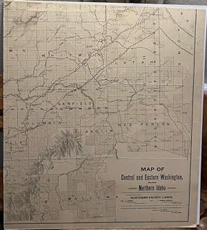
MAP DESCRIPTION: Published by the Northern Pacific Railroad Company for its associated land sales unit, Northern Pacific Lands. Very large, 40" (w) x 46.5" (h) between the neat lines with an inch border on all sides. On four sheets, each 20" (w) x 23.25" (h) mounted on stiff board. CONDITION DESCRIPTION: Lightly soiled, complete. Breaks only on the edges of the four individual sheets and where they border. Two very small worn spots on the NE panel. CONTENT DESCRIPTION: A very detailed, large-scale map of the Northern Pacific Railroad Company lands available for purchase. Includes the names of the Northern Pacific Lands agent office contacts in Tacoma, Washington. Details with state counties showing towns, drainages, rivers, streams and lakes. Uses some shading to depict topography of the mountain ranges. Depicts all of North Idaho from the Canadian and Montana borders south to the New Perce Reservation and the Wallowa country near the Blue Mountains. The south border of the map follows the basic flow the Columbia River west to where the DeChutes River joins it. The west border runs north from the Columbia River and DeChutes junction thru the Yakima Indian Reservation to Ellensburg and Lake Chelan and just across the Canadian border. The northern border follows the international border and includes some lands north into British Columbia and east to the Montana border. Includes the country near the headwaters of the Columbia. Where the NPR had lands available, there is excellent details of town locations, roads, railroads, and water. Having spent most of the last 45 years in NE Washington, I find this map endlessly fascinating and familiar. It shows towns, some lost to the damning of the Columbia and Snake River systems, as well as the railroad stations, lakes, roads, etc. Its size makes it a bit difficult to grasp in scale, it being printed and mounted on four separate panels makes it a bit easier to study and enjoy. N° de ref. del artículo 5801376
Contactar al vendedor
Denunciar este artículo
Detalles bibliográficos
Título: MAP OF CENTRAL AND EASTERN WASHINGTON, ...
Editorial: Northern Pacific Lands, Northern Pacific Railroad, St. Paul, Minn
Encuadernación: No Binding
Condición: Very Good
Edición: 1st Edition
![]()

