Descripción
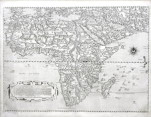
2 sheets joined, float-mounted and framed (19 1/8 x 24 4/8 inches, full margins showing the plate mark). AN EXCEPTIONALLY FINE engraved detailed map of Africa and the Middle East, from the Mediterranean in the north-west, to Arabia and the Gulf of Hormuz in the east, showing all major place names, mountain ranges, rivers and lakes, the long dedication to Thomaso Ravenna within an elegant mannerist strapwork cartouche lower left, with a fine compass rose, and marking the Equator and Tropics. THE FIRST APPEARANCE IN PRINT OF THE MOST UP-TO-DATE DEPICTION OF AFRICA In 1546, the Venetian Council of Ten issued an order that a map of Africa be prepared for the "Sala del Scude" of the Palazzo Ducale (Doge's Palace). This task was entrusted to the foremost Italian cartographer of the sixteenth century, Giacomo Gastaldi. More than two-hundred years later, in the 1760s, Gastaldi's map of Africa, along with another of China that he executed several years later, was painted over and the original lost to posterity. It was preserved, however, in the form of this splendid map of Africa, finely engraved and published by Paolo Forlani in 1562. Gastaldi (fl. 1542-1565) was the principal cartographer of the Venetian school of mapmaking. He was a native of the Piedmont region who made his career in Venice, eventually becoming official Cosmographer to the Venetian Republic. One of the foremost authorities on sixteenth-century European mapmakers, Robert Karrow, has described him as "one of the most important cartographers of the sixteenth century. He was certainly the greatest Italian mapmaker of his age." Following in the footsteps of his great colleague Gastaldi, Paolo Forlani was a Venetian publisher of many important maps and charts in the Renaissance. It was in Italy, and particularly in Venice, that the map trade was most highly developed during the first half of the sixteenth century. Venice was the most active port in the world, and successful trading expeditions necessitated accurate maps. The city also had a thriving, cosmopolitan scholarly community that took a keen interest in geography and in following the expansion of world horizons brought about by the Age of Discovery. In the previous century Venice had already become a clearing-house for geographical information, and the development of cartography in the city was further impelled by the accomplishment of Venetian printers and engravers. Forlani was perhaps the most prolific producer of maps in the mid-sixteenth century, and largely responsible for diffusing advanced geographical information to other parts of Europe. He was much-sought after as an engraver and mapmaker, particularly as he was adept at the difficult art of engraving lettering. Consequently, he was employed by four of the leading publishers of the period to prepare maps for them -- Giovanni Francesco Camocio, Ferrando Bertelli, and Bolognini Zaltieri from Venice, as well as Claudio Duchetti from Rome. This map is a prime example of Forlani's finest work, characterized by crisp engraving, close attention to detail, and an elegant, linear aesthetic. Africa had long held the European popular imagination and, like the New World, was the target of many voyages of discovery. From the early fifteenth century, the nautical school of Henry the Navigator had been extending Portuguese knowledge of the African coastline. Beginning in the 1460s, the goal was to round that continent's southern extremity to gain easier access to the riches of India (mainly black pepper and other spices) through a reliable sea route. In 1482, Diogo Cão discovered the Congo River, reaching as far as Cape Santa Maria, and then in 1488 Bartolomeu Diaz rounded the Cape of Good Hope, proving that access to the Indian Ocean was possible. Finally, in 1497-8, Vasco da Gama culminated a generation of Portuguese sea exploration when he continued beyond Diaz's tracks up the east coast of Africa and successfully landed at the southwestern coast of the Indian su. N° de ref. del artículo 72map248
Contactar al vendedor
Denunciar este artículo
![]()
