
Importe total (1 artículo artículos):
Destino del pedido:

ordnance survey map sheet fourth (14 resultados)
Ir a los resultados principales
Filtros de búsqueda
Tipo de artículo
- Todos los tipos de productos
- Libros (9)
- Revistas y publicaciones (No hay ningún otro resultado que coincida con este filtro.)
- Cómics (No hay ningún otro resultado que coincida con este filtro.)
- Partituras (No hay ningún otro resultado que coincida con este filtro.)
- Arte, grabados y pósters (No hay ningún otro resultado que coincida con este filtro.)
- Fotografías (No hay ningún otro resultado que coincida con este filtro.)
- Mapas (5)
- Manuscritos y coleccionismo de papel (No hay ningún otro resultado que coincida con este filtro.)
Condición Más información
- Nuevo (No hay ningún otro resultado que coincida con este filtro.)
- Como nuevo, Excelente o Muy bueno (No hay ningún otro resultado que coincida con este filtro.)
- Bueno o Aceptable (10)
- Regular o Pobre (3)
- Tal como se indica (1)
Encuadernación
Más atributos
- Primera edición (No hay ningún otro resultado que coincida con este filtro.)
- Firmado (No hay ningún otro resultado que coincida con este filtro.)
- Sobrecubierta (No hay ningún otro resultado que coincida con este filtro.)
- Con imágenes (9)
- No impresión bajo demanda (14)
Idioma (2)
Precio
- Cualquier precio
- Menos de EUR 20
- EUR 20 a EUR 45 (No hay ningún otro resultado que coincida con este filtro.)
- Más de EUR 45 (No hay ningún otro resultado que coincida con este filtro.)
Gastos de envío gratis
- Envío gratis a Estados Unidos de America (No hay ningún otro resultado que coincida con este filtro.)
Ubicación del vendedor
Valoración de los vendedores
-

Ordnance Survey of Great Britain - quarter-inch map - Fourth Edition- East Anglia, Sheet 9
Idioma: Inglés
Publicado por Ordnance Survey, United Kingdom, 1946
Librería: RIVERLEE BOOKS, Waltham Cross, HERTS, Reino Unido
Calificación del vendedor: 5 de 5 estrellas

EUR 10,62
Envío por EUR 13,95
Se envía de Reino Unido a Estados Unidos de AmericaCantidad disponible: 1 disponibles
Ańadir al carritoSoft cover. Condición: Fair. 1946. Card Covers. Book Condition: fair. mounted on linen.
-
Ordnance Survey Quarter-inch Map Of Great Britain Fourth Edition With National Grid Sheet 4 Glasgow And The Middle West
Publicado por Ordnance Survey Office, Southampton, UK, 1946
Librería: Willis Monie-Books, ABAA, Cooperstown, NY, Estados Unidos de America
Miembro de asociación: ABAA ESA ILAB
Calificación del vendedor: 5 de 5 estrellas
EUR 8,87
Envío por EUR 6,89
Se envía dentro de Estados Unidos de AmericaCantidad disponible: 1 disponibles
Ańadir al carritoSoftcover. Condición: Fair. Estado de la sobrecubierta: No Dust Jacket. Dampstaining to covers. Penetrates to the map slightly on one side, touching some text, very slightly to other side, touching the key, and in line with these a very small slight stain to each fold. Map has some very slight wrinkling. Covers have a chip and other edge wear. ; Large folded map, mounted on linen and attached to paper covers.
-

Ordnance Survey of Great Britain Quarter-Inch Map Fourth Edition, North Central. Sheet 2.
Idioma: Inglés
Publicado por The Director General Ordnance Survey, Southampton, 1935
Librería: Joy Norfolk, Deez Books, IPSWICH, Reino Unido
Calificación del vendedor: 5 de 5 estrellas
Mapa
EUR 9,54
Envío por EUR 19,68
Se envía de Reino Unido a Estados Unidos de AmericaCantidad disponible: 1 disponibles
Ańadir al carritoSoft cover. Condición: Good. Estado de la sobrecubierta: No Jacket (as published). Map on cloth. Some signs of wear / handling / use but still quite sound. All orders processed promptly and shipped from the UK.
-

Ordnance Survey of Great Britain: Quarter-Inch Map: Fourth Edition: Sheet 7: South Wales.
Publicado por Ordnance Survey, United Kingdom, 1934
Librería: Carmarthenshire Rare Books, Carmarthen, Reino Unido
Calificación del vendedor: 5 de 5 estrellas
EUR 5,96
Envío por EUR 20,84
Se envía de Reino Unido a Estados Unidos de AmericaCantidad disponible: 1 disponibles
Ańadir al carritoSoft cover. Condición: Very Good. Estado de la sobrecubierta: No Jacket Issued. 4th Edition. folding linen backed colour map with decorative card covers, cover edges a little chipped otherwise a very good clean and complete map. We are a real bookshop with real books situated in and shipping from the United Kingdom. Shelf 204.
-

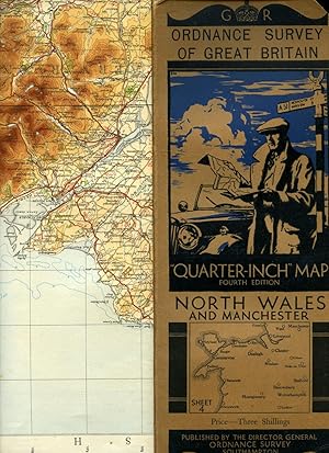
Ordnance Survey of Great Britain: Quarter-Inch Map: Fourth Edition: Sheet 4: North Wales and Manchester
Publicado por Ordnance Survey, United Kingdom, 1935
Librería: Carmarthenshire Rare Books, Carmarthen, Reino Unido
Calificación del vendedor: 5 de 5 estrellas
EUR 5,96
Envío por EUR 20,84
Se envía de Reino Unido a Estados Unidos de AmericaCantidad disponible: 1 disponibles
Ańadir al carritoSoft cover. Condición: Very Good. Estado de la sobrecubierta: No Jacket Issued. 4th Edition. folding linen backed colour map with decorative card covers, cover edges a little chipped otherwise a very good clean and complete map. We are a real bookshop with real books situated in and shipping from the United Kingdom. Shelf 204.
-
Ordnance Survey North Midlands and Lincolnshire. Sheet 6; Quarter-Inch Map, Fourth Edition, Military Edition, War Revision 1940
Publicado por Ordnance Survey, 1940
Librería: Polar Books, Llandudno, CONWY, Reino Unido
Calificación del vendedor: 5 de 5 estrellas
EUR 14,91
Envío por EUR 28,95
Se envía de Reino Unido a Estados Unidos de AmericaCantidad disponible: 1 disponibles
Ańadir al carritoCloth Map. Condición: Fair. Large folding cloth map, grubby, well used, wear along folds, remnants of old staples where it has been attached to the wall at some point. Showed all the aerodromes, landing graounds, seaplane anchorages etc., at the time. Historical reference. Quantity Available: 1. Shipped Weight: Under 1 kilogram. Category: Geography & Maps; Military & Warfare. Pictures of this item not already displayed here available upon request. Inventory No: 4115.
-

Ordnance Survey Map. Sheet 9. Fourth Edition. East Anglia. England.
Publicado por Ordnance Survey of Great Britain, 1939
Librería: MAE Books, Dunoon, ARL, Reino Unido
Calificación del vendedor: 5 de 5 estrellas
Mapa
EUR 17,89
Envío por EUR 9,26
Se envía de Reino Unido a Estados Unidos de AmericaCantidad disponible: 1 disponibles
Ańadir al carritoNo Binding. Condición: Good. No Jacket. 4th Edition. Linen backed paper map of East Anglia, England. Moderate creasing at edges. Intact. Wearing at folds, but no splits. Endorsed at top in red, 'NOT TO BE PUBLISHED'. Scale : Quarter-Inch to One Statute Mile = 1/253440. Map has Land Aerodromes, Landing Grounds, Water Aerodromes, Seaplane Mooring Areas or Anchorages ands Airship Bases shown, kin red. Air Information correct as of 30.1.39.
-
England, South. Sheet 11. Ordnance Survey of Great Britain. Quarter Inch Map. FOURTH EDITION.
Idioma: Inglés
Publicado por Ordnance Survey, Southampton, 1934
Librería: SAVERY BOOKS, Brighton, East Sussex, Reino Unido
Calificación del vendedor: 5 de 5 estrellas
EUR 18,95
Envío por EUR 40,53
Se envía de Reino Unido a Estados Unidos de AmericaCantidad disponible: 1 disponibles
Ańadir al carritoSoft cover. Condición: Very Good. Fourth Edition. 4th edition. Cover price: Three shillings. BACK COVER HAS A SHORT TEAR. Map is neatly folded. Clean. No inscriptions. Dispatched ROYAL MAIL FIRST CLASS with TRACKING next working day or sooner securely boxed in cardboard. ref F5. England, South. Sheet 11. Ordnance Survey of Great Britain. Quarter Inch Map. FOURTH EDITION.
-
South-West. Sheet 10. Ordnance Survey of Great Britain. Quarter Inch Map ---------- Fourth Edition
Idioma: Inglés
Publicado por Ordnance Survey, Southampton (UK), 1935
Librería: SAVERY BOOKS, Brighton, East Sussex, Reino Unido
Calificación del vendedor: 5 de 5 estrellas
EUR 18,95
Envío por EUR 40,53
Se envía de Reino Unido a Estados Unidos de AmericaCantidad disponible: 1 disponibles
Ańadir al carritoSoft cover. Condición: Very Good. 4th Edition. 4th Edition. Clean. No inscriptions. Neatly folded map is not torn. Cover price: Three shillings. Dispatched ROYAL MAIL FIRST CLASS with TRACKING next working day or sooner securely boxed in cardboard. ref F5. South-West. Sheet 10. Ordnance Survey of Great Britain. Quarter Inch Map. Fourth Edition.
-
ORDNANCE SURVEY HISTORICAL MAP AND GUIDE: ROMAN BRITAIN South Sheet Fourth Edition (Revised): SCALE 1:625,000
Publicado por Ordnance Survey (Southampton), GB, 1994
Librería: Richard Sylvanus Williams (Est 1976), WINTERTON, Reino Unido
Calificación del vendedor: 5 de 5 estrellas
EUR 5,73
Envío por EUR 34,74
Se envía de Reino Unido a Estados Unidos de AmericaCantidad disponible: 1 disponibles
Ańadir al carritoPaperback. Condición: VG+. In very good plus condition with very minor signs of wear and/or age. Covers a bit worn.
-
![Imagen del vendedor de Ordnance Survey.Quarter-Inch Map. The Eastern Highlands. Fourth Edition with National Grid. Sheet 5. [Scale: Quarter-Inch to One Mile]. BRIGHT, CLEAN COPY OF THE 1946 ISSUE a la venta por Island Books](https://pictures.abebooks.com/inventory/md/md21997295414.jpg)
Ordnance Survey.Quarter-Inch Map. The Eastern Highlands. Fourth Edition with National Grid. Sheet 5. [Scale: Quarter-Inch to One Mile]. BRIGHT, CLEAN COPY OF THE 1946 ISSUE
Publicado por Ordnance Survey, Chessington, [1946], 1946
Librería: Island Books, Thakeham, West Sussex, Reino Unido
Calificación del vendedor: 4 de 5 estrellas

Mapa
EUR 19,08
Envío por EUR 26,86
Se envía de Reino Unido a Estados Unidos de AmericaCantidad disponible: 1 disponibles
Ańadir al carritoFolding coloured map on paper measuring 24.0 x 35.0 ins (approx. 61 x 89 cms) folding in 16 panels to 12.5 x 5.0 ins (approx. 32.0 x 13 cms); printed card covers, a very good, bright, clean copy. The cover is Ellis Martin's 'Medallion Royal Arms' with blue border and location map, in long format. The generic form of this design became the first standard post-war OS cover. Browne, 96.2.a.
-

Ordnance Survey of Great Britain: Quarter-Inch Map: Fourth Edition: Sheet 4: North Wales and Manchester
Publicado por Ordnance Survey Office, Southhampton, 1935
Librería: anglimm books, Truro, Reino Unido
Calificación del vendedor: 4 de 5 estrellas
Mapa
EUR 10,73
Envío por EUR 34,68
Se envía de Reino Unido a Estados Unidos de AmericaCantidad disponible: 1 disponibles
Ańadir al carritoSoft cover. Condición: Very Good. Card Covers rubbed round the edges, map is well preserved but with slight nicks at corner folds.
-
Ordnance Survey of Great Britain | Quarter-Inch Map | Fourth Edition | Sheet 4: North Wales and Manchester
Publicado por Published by Minister of Agriculture and Fisheries for Ordnance Survey Office, Southampton Fourth Edition . 1934., 1934
Librería: Little Stour Books PBFA Member, Canterbury, Reino Unido
Miembro de asociación: PBFA
Calificación del vendedor: 5 de 5 estrellas
EUR 14,91
Envío por EUR 34,74
Se envía de Reino Unido a Estados Unidos de AmericaCantidad disponible: 1 disponibles
Ańadir al carritoPublisher's original illustrated front cover brown and blue card covered single-sided map. 12'' x 5'' which folds out to measure 42" x 24". Scale of map is 4 miles to 1 inch, mounted in sections on linen, includes fold-out sheet of 17 town plans with with inset details of Mersey Tunnel Charges and Horse Power limitations. Small chip to the top front corner of the front cover and in Very Good clean and crisp condition. Member of the P.B.F.A. CARTOGRAPHY, MAPS, PLANS.
-
Ordnance Survey Quarter Inch Map of The Border Region Sheet 1, Fourth Edition War Revision 1940
Idioma: Inglés
Publicado por Ordnance Survey, 1943
Librería: Morning Mist Books and Maps, Cirencester, Reino Unido
Calificación del vendedor: 5 de 5 estrellas
Mapa
EUR 11,93
Envío por EUR 52,10
Se envía de Reino Unido a Estados Unidos de AmericaCantidad disponible: 1 disponibles
Ańadir al carritoNo Binding. Condición: Very Good. Military edition with related gridlines overprinted but based on the pre-war fourth edition. Revised to 1939. Map mounted in sections on linen with Stanford covers and label. No holes or tears, a bright copy. Includes aerodromes, landing sites etc. Print code: 30,000/8/43 G.S., G.S. No. 3957. Further details available on request. (q99).


