
Importe total (1 artículo artículos):
Destino del pedido:

map cape cod de walling gray (1 resultados)
Ir a los resultados principales
Filtros de búsqueda
Tipo de artículo
- Todos los tipos de productos
- Libros (1)
- Revistas y publicaciones (No hay ningún otro resultado que coincida con este filtro.)
- Cómics (No hay ningún otro resultado que coincida con este filtro.)
- Partituras (No hay ningún otro resultado que coincida con este filtro.)
- Arte, grabados y pósters (No hay ningún otro resultado que coincida con este filtro.)
- Fotografías (No hay ningún otro resultado que coincida con este filtro.)
- Mapas (No hay ningún otro resultado que coincida con este filtro.)
- Manuscritos y coleccionismo de papel (No hay ningún otro resultado que coincida con este filtro.)
Condición Más información
- Nuevo (No hay ningún otro resultado que coincida con este filtro.)
- Como nuevo, Excelente o Muy bueno (No hay ningún otro resultado que coincida con este filtro.)
- Bueno o Aceptable (No hay ningún otro resultado que coincida con este filtro.)
- Regular o Pobre (No hay ningún otro resultado que coincida con este filtro.)
- Tal como se indica (1)
Encuadernación
- Todas
- Tapa dura (No hay ningún otro resultado que coincida con este filtro.)
- Tapa blanda (No hay ningún otro resultado que coincida con este filtro.)
Más atributos
- Primera edición (No hay ningún otro resultado que coincida con este filtro.)
- Firmado (No hay ningún otro resultado que coincida con este filtro.)
- Sobrecubierta (No hay ningún otro resultado que coincida con este filtro.)
- Con imágenes (1)
- No impresión bajo demanda (1)
Idioma (1)
Precio
- Cualquier precio
- Menos de EUR 20 (No hay ningún otro resultado que coincida con este filtro.)
- EUR 20 a EUR 45 (No hay ningún otro resultado que coincida con este filtro.)
- Más de EUR 45
Gastos de envío gratis
- Envío gratis a Estados Unidos de America (No hay ningún otro resultado que coincida con este filtro.)
Ubicación del vendedor
Valoración de los vendedores
-
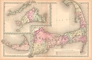
Map of Cape Cod
Ańo de publicación: 1871
Librería: Art Source International Inc., Boulder, CO, Estados Unidos de America
Calificación del vendedor: 5 de 5 estrellas

EUR 310,58
Envío por EUR 13,78
Se envía dentro de Estados Unidos de AmericaCantidad disponible: 2 disponibles
Ańadir al carritoThis hand colored map is from Walling and Grays Official Topographical Atlas of Massachusetts from Astronomical, Trigonometrical, and Various Local Surveys published in 1871. This bright pastel map of Cape Cod identifies counties and important cities, water bodies, rivers, major roads and hills. Insets at the same scale illusrate Nantucket, the Elizabeth Islands and Dukes Island with the vineyard region identified. This map measures 23.5 inches by 16.5 inches.