Importe total (1 artículo artículos):
Destino del pedido:

TOURIST INFORMATION BUREAU (18 resultados)
Ir a los resultados principales
Tipo de artículo
- Todo tipo de artículos
- Libros (16)
- Revistas y publicaciones
- Cómics
- Partituras
- Arte, grabados y pósters
- Fotografías
- Mapas (2)
-
Manuscritos y
coleccionismo de papel
Condición
Encuadernación
Más atributos
- Primera edición (3)
- Firmado
- Sobrecubierta
- Con imágenes del vendedor (12)
- Sin impresión bajo demanda (16)
Gastos de envío gratis
Ubicación del vendedor
Valoración de los vendedores
-
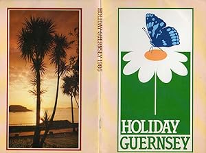
Holiday Guernsey
Publicado por Tourist Information Bureau, St Peter Port, Guernsey, UK, 1986
Librería: fourleafclover books, St. Louis, MO, Estados Unidos de America
Valoración del vendedor:

Soft Cover-Stapled. Condición: Very Good. 32 pgs. Illustrated; Photo Tour, History; Bailiwick of Guernsey; St. Peter Port - Walking Around - Things Past, Out and About - Island Neighbours. Note inside back cover.
-

MAP OF OREGON, 1923, ALL ROADS LEAD TO OREGON, THE MOST BEAUTIFUL OF WESTERN STATES
Publicado por Oregon Touris & Information Bureau, Portland, OR, 1923
Librería: Larry W Price Books, Portland, OR, Estados Unidos de America
Valoración del vendedor:
Pamphlet. Condición: Very Good. Color Road Map & FoldOut Brochure, 14 x 20.5 Inches, Other side is Map of just Western Oregon extending North-South, Folds to 5.5 x 7.25 Inches, VG.
-
ALL ROADS LEAD TO OREGON - THE MOST BEAUTIFUL OF WESTERN STATES [1923 ROAD MAP]
Publicado por Oregon Tourist & Information Bureau, Portland, OR, 1923
Librería: Larry W Price Books, Portland, OR, Estados Unidos de America
Valoración del vendedor:
Pamphlet. Condición: Good. Lge FoldOut Road Map with Color Illus Highways (14 x 22 Inches), Obverse shows entire state; reverse shows just southern Oregon from Roseburg South, Folds to 5.5 x 7 Inches, edgechips & paper slightly wrinkled else Good (Neat early Highway Map - the road past the Dalles to Pendleton is gravel).
-
Official List of Jersey Holiday Accommodation 1953
Publicado por Jersey Committee of Tourism, 1953
Librería: Lion Books PBFA, Kidderminster, WORCS, Reino Unido
Miembro de asociación: PBFA
Valoración del vendedor:

Original o primera edición
Softcover. Condición: Good+. First Edition. Includes a companion publication supplement; being a 48 page coloured presentation booklet with full descriptive matter, both having stapled spine as issued, main copy has rubbing to extremeties, with 4omm tear to head spine. ; 8vo 8" - 9" tall; Unpaginated pages.
-
NEW BRUNSWICK. CANADA'S UNSPOILED PROVINCE BY THE SEA. THE SUMMER PLAYGROUND OF NORTH AMERICA. HUNTING, FISHING, BATHING, GOLF, SCENERY, BOATING.
Publicado por (Fredericton, 1935)., 1935
Librería: Steve Finer - Rare Books, Greenfield, MA, Estados Unidos de America
Miembro de asociación: SNEAB
Valoración del vendedor:
8vo, color printed pictorial wrappers, 28pp. Halftone illustrations. The wrapper covers are attractively romanticized. Very Good copy.
-

Jersey in Pictures
Publicado por States of Jersey Committee of Tourism, St. Helier
Librería: Lazy Letters Books, Market Rasen, Reino Unido
Valoración del vendedor:
Libro
Soft cover. Condición: Very Good. Undated, c. 1945-1954, as advises you to bring your ration card with you. Minimal wear.
-
![Imagen del vendedor de Game of British Columbia (1907) [LeatherBound] a la venta por True World of Books](https://pictures.abebooks.com/inventory/md/md31618614604.jpg)
Game of British Columbia (1907) [LeatherBound]
Ańo de publicación: 2023
Libro Impresión bajo demanda
LeatherBound. Condición: New. LeatherBound edition. Condition: New. Reprinted from 1907 edition. Leather Binding on Spine and Corners with Golden leaf printing on spine. Bound in genuine leather with Satin ribbon page markers and Spine with raised gilt bands. A perfect gift for your loved ones. NO changes have been made to the original text. This is NOT a retyped or an ocr'd reprint. Illustrations, Index, if any, are included in black and white. Each page is checked manually before printing. As this print on demand book is reprinted from a very old book, there could be some missing or flawed pages, but we always try to make the book as complete as possible. Fold-outs, if any, are not part of the book. If the original book was published in multiple volumes then this reprint is of only one volume, not the whole set. Sewing binding for longer life, where the book block is actually sewn (smythe sewn/section sewn) with thread before binding which results in a more durable type of binding. Pages: 74.
-
![Imagen del vendedor de The timber and pulp wood industries of British Columbia (1905) [LeatherBound] a la venta por True World of Books](https://pictures.abebooks.com/inventory/md/md31618658938.jpg)
The timber and pulp wood industries of British Columbia (1905) [LeatherBound]
Ańo de publicación: 2023
Libro Impresión bajo demanda
LeatherBound. Condición: New. LeatherBound edition. Condition: New. Reprinted from 1905 edition. Leather Binding on Spine and Corners with Golden leaf printing on spine. Bound in genuine leather with Satin ribbon page markers and Spine with raised gilt bands. A perfect gift for your loved ones. NO changes have been made to the original text. This is NOT a retyped or an ocr'd reprint. Illustrations, Index, if any, are included in black and white. Each page is checked manually before printing. As this print on demand book is reprinted from a very old book, there could be some missing or flawed pages, but we always try to make the book as complete as possible. Fold-outs, if any, are not part of the book. If the original book was published in multiple volumes then this reprint is of only one volume, not the whole set. Sewing binding for longer life, where the book block is actually sewn (smythe sewn/section sewn) with thread before binding which results in a more durable type of binding. Pages: 62.
-
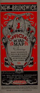
Map of New Brunswick
Publicado por Bureau of Information and Tourist Travel, Fredericton, New Brunswick, 1936
Librería: Harry E Bagley Books Ltd, Fredericton, NB, Canada
Valoración del vendedor:
Mapa
Paper. Condición: Very Good. brochure with full color wrap, opening to color map ; 58 x 83 cm, showing New Brunswick, Nova Scotia, Prince Edward Island, Eastern United States, Quebec, & Eastern Section of Ontario. showing Steamship routes and ferries, Railways, Road milage indicated, etc "Prepared with assistance of New Brunswick Tourist Bureau and N.B. Automobile Association." Index, mileage table and general information on verso. in very good condition.
-
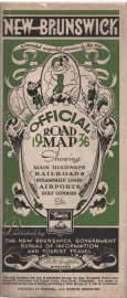
Map of New Brunswick indicating motor roads, railways and recreational Resources,1935
Publicado por Fredericton, New Brunswick : New Brunswick Govt. Bureau of Information & Tourist Travel,, Fredercton, New Brunswick, 1936
Librería: Harry E Bagley Books Ltd, Fredericton, NB, Canada
Valoración del vendedor:
Libro
Paper. Condición: Very Good. Panel title: New Brunswick official government map, 1935. Includes a synopsis of New Brunswick motor vehicle laws. 1 map : color ; 62 x 65 cm., Scale [1:633,600]., On verso: Sketch map indicating main automobile roads into New Brunswick; Canadian customs regulations; charts of distances; etc.
-
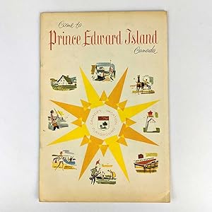
Come to Prince Edward Island, Canada: Canada's Vacation Playground
Publicado por Prince Edward Island Tourist and Information Bureau, Charlottetown, 1959
Librería: Book Merchant Jenkins, ANZAAB / ILAB, Woolloongabba, QLD, Australia
Miembro de asociación: ANZAAB ILAB IOBA
Valoración del vendedor:
Softcover. Condición: Very Good. 25cm x 17cm. 32 pages, illustrations, some colour, map. Illustrated saddle-stapled wrappers. Minor shelf wear and tanning. Shipped Weight: .08 kilos.
-
The Old Oregon Trail
Publicado por Old Oregon Trail Association; The Oregon Tourist and Information Bureau, Baker, OR; Portland, OR, 1922
Librería: Barry Cassidy Rare Books, Sacramento, CA, Estados Unidos de America
Valoración del vendedor:
Libro
Soft cover. Condición: Very Good. Original publisher's white paper wrappers with staple binding. Alternate title on front cover: "Story of the Old Oregon Trail: The World's Most Historic Highway and the Road to America's Scenic Wonderland." 5 1/4" x 9." Twenty-four pages, complete. Several small black-and-white illustrations, complete. Many of the illustrations are simplified maps showing sections of the Oregon Trail with noted towns and places of interest. Pages are very clean and intact except for light age toning, a few small wrinkles and creases and slightly bumped corners. Covers are clean and intact overall but have two black library stamps, light soiling, slight age toning, light to moderate darkening, a few small stains or spots of discoloration, and a few small wrinkles and creases. A Very Good copy. A concise history about the Oregon Trail. Author Walter E. Meacham, President of the Old Oregon Trail Association, describes different expeditions and migrations undertaken on the Oregon Trail by different explorers, travelers, and pioneers. Meacham begins with a brief history of the fur trading industry in the Pacific Northwest. Then he proceeds to describe the Hunt expedition of the early nineteenth century that traveled to Fort Astoria. He highlights noted members of the Hunt party; the arduous toil and dangers of the journey; frequent interactions and trade with Indigenous Peoples along the way; hardships and the massacre along the Snake River (colloquially called the "Mad River"); and the resourcefulness and fortitude of the only Indigenous woman on the expedition, Marie Dorian. Meacham then briefly describes the expedition of Dr. Whitman. The text that follows describes the 1852 emigrant train on the Oregon Trail. Meacham notes the numerous casualties on the trail resulting from cholera. He also pays tribute to pioneer Ezra Meeker who undertook several expeditions to mark and preserve the Oregon Trail. A special tribute is given to widowed pioneer women who took charge of the wagons and led and continued the journey onward after their husbands had passed. Meacham concludes his history with a chronological development of land along the trail with the advent of modern transportation and technology.
-
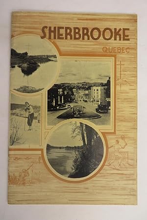
Sherbrooke, Quebec
Publicado por The Tourist Information Bureau n.d., Sherbrooke, Quebec
Librería: Attic Books (ABAC, ILAB), London, ON, Canada
Miembro de asociación: ABAC ILAB
Valoración del vendedor:
Pamphlet. Condición: Very good. 12p. 23 cm. Includes foldout tourist map of Sherbrooke. Stapled paperback brochure. Bilingual publication. No publication date, appears to be a mid-twentieth century publication. Includes numerous black and white photographs promoting the region and tourist activities. Some soiling to paper cover. Pages clean. Text and images clear and unmarked. Very good condition. Historic ephemera that captures a moment in Sherbrooke, Quebec's history as a community and as a tourist destination. Subjects include: nature experiences; sports; historic buildings; country clubs; and seasonal options for summer and winter.
-
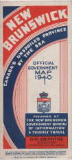
Map of New Brunswick : Canada's unspoiled province by the sea ; official government map 1940
Publicado por New Brunswick government, Bureau of Information and Tourist Travel, Frederiction, N.B, 1940
Librería: Harry E Bagley Books Ltd, Fredericton, NB, Canada
Valoración del vendedor:
Mapa
Hardcover. Condición: Very Good. front pane. in color, 1 map : color ; 68 x 61 cm., scale [ca. 1:650,000]., Panel title. Includes highway key. Historical site and Canadian customs regulations information, mileage charts, and ancillary map, Main connecting highway routes with the Province of New Brunswick.very good condition. postage wil be reduced.
-
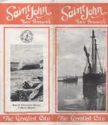
SAINT JOHN, New Brunswick, The Loyalist City
Publicado por Tourist Information Bureau, Saint John, 1928
Librería: Harry E Bagley Books Ltd, Fredericton, NB, Canada
Valoración del vendedor:
Libro
Paperbound. Condición: Very Good. 16 pp brochure, stapled at spine, 23.5 x 10.5 cm (9.5 x 4 inches) folded, opening to 23.5 x 20.5cm (9.5 x 8 inches) , illustrated, (42 area firms represented) center-spread panarama of King's Square and new Admiral Beatty Hotel, light soil to front, else v.g. A most informative brochure, with info on the city and area, businesses, hunting and fishing, area buildings, etc.
-
Guide to new Palestine
Publicado por Jerusalem : Published by the Zionist Information Bureau for Tourists in Palestine, 1935
Librería: Sequitur Books, Boonsboro, MD, Estados Unidos de America
Miembro de asociación: IOBA
Valoración del vendedor:
Libro
Paperback. Condición: Fair. Softcover. 8th edition. Original front wrap, lacking rear wrap. Gray library tape to spine. Minor soiling. owners stamp to maps. Chip loss to front wrap.
-
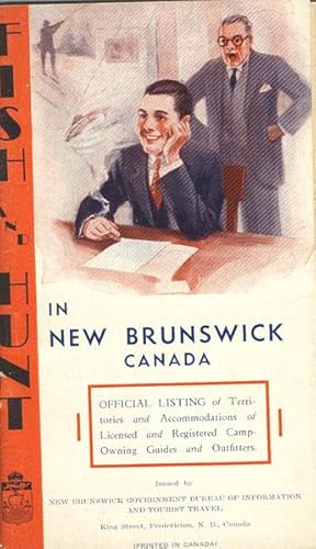
FISH AND HUNT IN NEW BRUNSWICK CANADA. OFFICIAL LISTING OF TERRITORIES AND ACCOMMODATIONS OF LICENSED AND REGISTERED CAMP-OWNING GUIDES AND OUTFITTERS
Publicado por Privately printed, n.d. [ca 1940]., N.P., 1940
Librería: BUCKINGHAM BOOKS, ABAA, ILAB, IOBA, GREENCASTLE, PA, Estados Unidos de America
Miembro de asociación: ABAA ILAB IOBA RMABA
Valoración del vendedor:
Original o primera edición
First edition. 7 1/2" x 4 1/2" in color pictorial wrappers. 51 [i-iii] pp., foreword, index. A directory of fishing, hunting and bird-shooting guides, camps, and outfitters broken down into counties and offering brief information on location, what animals, birds or fish one can expect to find, local railroad station. Information on fishing and hunting seasons, licenses. Light soiling and rubbing to wrappers as well as wrapper beginning to separate from text block. Very good.
-
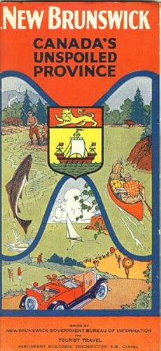
NEW BRUNSWICK. CANADA'S UNSPOILED PROVINCE
Publicado por New Brunswick Government Bureau of Information and Tourist Travel, 1929., Fredericton, 1929
Librería: BUCKINGHAM BOOKS, ABAA, ILAB, IOBA, GREENCASTLE, PA, Estados Unidos de America
Miembro de asociación: ABAA ILAB IOBA RMABA
Valoración del vendedor:
Original o primera edición
First edition. 9 1/24" x 11" tri-folded and housed in 9 1/4" x 4 1/4" colorful pictorial covers. 28 pp., triple column text, maps, illustrations, table of distances. Overview of New Brunswick followed by one page of text on the St. Stephen Gateway, Passamaquoddy Islands, St. Andrews-by-the-Sea, St. Goerge and Lake Utopia, Saint John, the Kennebecasis Valley and St. Martins, Sussrx, Albert County, Moncton, Westmorland County, along the East Coast, Miramichi, Bathurst and Gloucester County, the Campbellton Gateway, Edmundston, Grand Falls and the Tobque, the Woodstock Gateway, the Saint John River Valley, Fredericton, Grand Lake and Washademoak. Surrounding each black of text are numerous black and white photographs depicting that which is written about. 71/2" x 7"sketch map of New Brunswick indicating main automobile roads into New Brunswick. Official Highway Map of New Brunswick showing numbered highways, routes, mileages. 9 1/4" x 11" black and white map showing New Brunswick main roads. Edges of pages lightly worn. Spine of covers rubbed and with light wear to the extremities. Very good. A nice item.