Importe total (1 artículo artículos):
Destino del pedido:

THE FISHERIES, GAME AND FOREST COMMISSION (3 resultados)
Ir a los resultados principales
Tipo de artículo
- Todo tipo de artículos
- Libros (3)
- Revistas y publicaciones
- Cómics
- Partituras
- Arte, grabados y pósters
- Fotografías
- Mapas
-
Manuscritos y
coleccionismo de papel
Condición
- Todo
- Nuevos
- Antiguos o usados
Encuadernación
- Todo
- Tapa dura (2)
- Tapa blanda
Más atributos
- Primera edición (1)
- Firmado
- Sobrecubierta
- Con imágenes del vendedor (2)
- Sin impresión bajo demanda
Ubicación del vendedor
Valoración de los vendedores
-
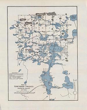
Map of Township Twenty Franklin County and Vicinity (New York)
Ańo de publicación: 1907
Librería: Art Source International Inc., Boulder, CO, Estados Unidos de America
Valoración del vendedor:

This map of Franklin County details the Highway to Tupper Lake, railroads, steamboat routes, trails, swamps, marshes, ponds, lakes, and more. It shows numerous camp sites, hotels, and lodges throughout the area. It stretches as far north as Fish Pond Mountain and upper St. Regis Lake, as far east as Lake Clear, as far west as Wind Fall Pond, and as far south as the Stony Creek Ponds. Other bodies of water shown include the Hoel Pond, Deer Pond, Weller Pond, and Round Lake among others. This map measures 13.25 inches by 10 inches.
-

Map of the Adirondack Lands: 1895
Publicado por State of New York, Albany, NY, 1895
Librería: Brillig's Books, Kingston, NY, Estados Unidos de America
Valoración del vendedor:

Libro
Hardcover. Condición: Good. Estado de la sobrecubierta: No DJ. The Fisheries, Game and Forest Commission. Four quadrant folded colour maps 34x27ea. in green cloth embossed folio w/ ribbon ties. Some tears at folds and age-toning to margins.
-
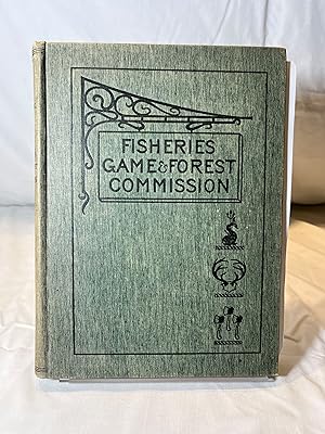
Fisheries, Game And Forests Commission Of The State Of New York Third Annual Report Of The Commissioners Of Fisheries, Game And Forests Of The State Of New York Report for 1897
Publicado por Wink Hallenbeck Craw ford Co., Albany, New York, U.S.A., 1898
Original o primera edición
Hardcover. Condición: Very Good Minus. Estado de la sobrecubierta: No Dust Jacket. Various Ilustrador. First edition. The green, blind stamped, boards have an illustration of a wrought iron work displaying a sign, 'Fisheries Game & Forest Commission', with a fish, deer antlers and three axes. They are illustrated in black. The previous owner has signed the front free page and there is a signature stamp from the State Superintendent of Public Instruction - 'Charles R. Skinner'. There is one tipped in illustration missing on page 318 entitled 'Wake Robin' Sugar Bush. The book contains a fold out map on page 372. The book is in very good condition other than the missing illustration. The book contains 455 pages. B1, C.