Importe total (1 artículo artículos):
Destino del pedido:

ROBINSON, ELISHA (38 resultados)
Ir a los resultados principales
Tipo de artículo
- Todo tipo de artículos
- Libros (38)
- Revistas y publicaciones
- Cómics
- Partituras
- Arte, grabados y pósters
- Fotografías
- Mapas
-
Manuscritos y
coleccionismo de papel
Condición
Encuadernación
Más atributos
- Primera edición (1)
- Firmado
- Sobrecubierta
- Con imágenes del vendedor (20)
- Sin impresión bajo demanda (33)
Gastos de envío gratis
Ubicación del vendedor
Valoración de los vendedores
-
Contemporary Australian Plays: The Hotel Sorrento, Dead White Males, Two, The 7 Stages of Grieving, The Popular Mechanicals (Play Anthologies)
Publicado por Methuen Drama, 2001
ISBN 10: 0413767604ISBN 13: 9780413767608
Librería: SecondSale, Montgomery, IL, Estados Unidos de America
Valoración del vendedor:

Libro
Condición: Acceptable. Item in acceptable condition! Textbooks may not include supplemental items i.e. CDs, access codes etc.
Más opciones de compra de otros vendedores en IberLibro
Nuevo desde EUR 20,77
Usado desde EUR 9,50
Encuentre también Tapa blanda
-

In What Respects May the Administration of the Poor Law Be Improved A Paper Read at Bristol, at the Request of the Council of the Social Science Association Classic Reprint
Publicado por Forgotten Books, 2018
ISBN 10: 1334297835ISBN 13: 9781334297830
Librería: PBShop.store US, Wood Dale, IL, Estados Unidos de America
Valoración del vendedor:
Libro
PAP. Condición: New. New Book. Shipped from UK. Established seller since 2000.
Más opciones de compra de otros vendedores en IberLibro
Nuevo desde EUR 15,59
-

Atlas of the City of Detroit and Suburbs : Embracing Portions of Hamtramck; Springwells and Greenfield Townships; Wayne County; Mich. From Offical Records; Private Plans & Actual Surveys
Publicado por Legare Street Press, 2021
ISBN 10: 1014927803ISBN 13: 9781014927804
Librería: Ria Christie Collections, Uxbridge, Reino Unido
Valoración del vendedor:
Libro Impresión bajo demanda
Condición: New. PRINT ON DEMAND Book; New; Fast Shipping from the UK. No. book.
Más opciones de compra de otros vendedores en IberLibro
Nuevo desde EUR 16,34
-
![Imagen del vendedor de In what respects may the administration of the poor law be improved? : a paper read at Bristol, at the request of the Council of the Social Science Association Volume lcollecon of ish pamphle [LeatherBound] a la venta por True World of Books](https://pictures.abebooks.com/inventory/md/md31533339066.jpg)
In what respects may the administration of the poor law be improved? : a paper read at Bristol, at the request of the Council of the Social Science Association Volume lcollecon of ish pamphle [LeatherBound]
Ańo de publicación: 2023
Libro Impresión bajo demanda
LeatherBound. Condición: New. Leather Binding on Spine and Corners with Golden leaf printing on spine. Bound in genuine leather with Satin ribbon page markers and Spine with raised gilt bands. A perfect gift for your loved ones. Reprinted from 1869 edition. NO changes have been made to the original text. This is NOT a retyped or an ocr'd reprint. Illustrations, Index, if any, are included in black and white. Each page is checked manually before printing. As this print on demand book is reprinted from a very old book, there could be some missing or flawed pages, but we always try to make the book as complete as possible. Fold-outs, if any, are not part of the book. If the original book was published in multiple volumes then this reprint is of only one volume, not the whole set and contains approximately 32 pages. IF YOU WISH TO ORDER PARTICULAR VOLUME OR ALL THE VOLUMES YOU CAN CONTACT US. Resized as per current standards. Sewing binding for longer life, where the book block is actually sewn (smythe sewn/section sewn) with thread before binding which results in a more durable type of binding. Language: English.
-
![Imagen del vendedor de Atlas of the City of Detroit and suburbs : embracing portions of Hamtramck, Springwells and Greenfield Townships, Wayne County, Mich. from offical records, private plans & actual surveys (1885) [LeatherBound] a la venta por True World of Books](https://pictures.abebooks.com/inventory/md/md31618664007.jpg)
Atlas of the City of Detroit and suburbs : embracing portions of Hamtramck, Springwells and Greenfield Townships, Wayne County, Mich. from offical records, private plans & actual surveys (1885) [LeatherBound]
Ańo de publicación: 2023
Libro Impresión bajo demanda
LeatherBound. Condición: New. LeatherBound edition. Condition: New. Reprinted from 1885 edition. Leather Binding on Spine and Corners with Golden leaf printing on spine. Bound in genuine leather with Satin ribbon page markers and Spine with raised gilt bands. A perfect gift for your loved ones. NO changes have been made to the original text. This is NOT a retyped or an ocr'd reprint. Illustrations, Index, if any, are included in black and white. Each page is checked manually before printing. As this print on demand book is reprinted from a very old book, there could be some missing or flawed pages, but we always try to make the book as complete as possible. Fold-outs, if any, are not part of the book. If the original book was published in multiple volumes then this reprint is of only one volume, not the whole set. Sewing binding for longer life, where the book block is actually sewn (smythe sewn/section sewn) with thread before binding which results in a more durable type of binding. Pages: 126 Robinson, E. (Elisha),Pidgeon, R. H. (Roger H.),Mueller, A. H. (August H.),Bourquin, F. (Frederick), b. 1808,Foxen's Real Estate Mart.
-
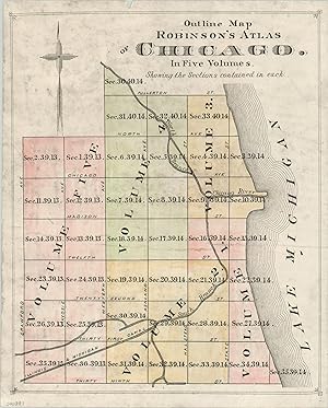
Outline Map of Chicago Index map to a massive five volume insurance atlas of Chicago.
Ańo de publicación: 1886
Librería: Curtis Wright Maps, Berwyn, IL, Estados Unidos de America
Miembro de asociación: ESA MWABA
Valoración del vendedor:

Condición: Very Good. The Great Chicago Fire in 1871 and subsequent rapid rebuilding of the city added to the need for accurate and reliable urban maps. Several companies, Sanborn being the most well known, created specialized fire insurance atlases. These large, bound tomes included detailed small scale maps that showed individual buildings color coded by construction material. Insurance companies would use the maps as a reference when determining rates and premiums. Elisha Robinson published a five volume set in 1886, covered by this index map that was issued to accompany the atlases. The Chicago River, Illinois and Michigan Canal and a handful of street names are labeled. Each section is numbered individually and colored for easy identification. Sheet Width (in) 8 Sheet Height (in) 9.9 Condition Description The sheet shows minor wear and some areas where the color has been obscured through soiling. Very good overall.
-
![Imagen del vendedor de Section 35.39.14 And S.E. 1/4 Sec 34.39.14 [Chicago] One of Chicago's oldest green spaces, and the future site of Burnham Park. a la venta por Curtis Wright Maps](https://pictures.abebooks.com/inventory/md/md31695373470.jpg)
Section 35.39.14 And S.E. 1/4 Sec 34.39.14 [Chicago] One of Chicago's oldest green spaces, and the future site of Burnham Park.
Ańo de publicación: 1886
Librería: Curtis Wright Maps, Berwyn, IL, Estados Unidos de America
Miembro de asociación: ESA MWABA
Valoración del vendedor:
Condición: Good. This fabulously detailed map of several city blocks in Chicago's Douglas neighborhood was published in response to the devastating fire that rampaged through the city between October 8-10, 1871. Elisha Robinson, its creator, was one of the numerous publishers who issued atlases specifically for the fire insurance industry. In order to properly assess risk, insurers needed information on building size, construction material, and the availability of water. Surveys were painstakingly performed, usually on foot, and the results are among the most complete snapshots of the city's physical makeup in the late 19th and early 20th centuries. In theory, every single building that existed at the time of publication is outlined within the borders of the map. Color was applied by stencil and shows the construction material of each structure; pink is brick, yellow is wood, brown is stone, and blue is iron. Crosses on a building footprint indicate its use as a stable, or otherwise likely to hold combustible materials. Water and sewer lines, street elevation (which affects the flow), fire hydrants, and cisterns are also all noted. The image is bounded by Grand Boulevard (Martin Luther King Drive), the city limits at Pershing Road, 35th Street, and Lake Michigan. It depicts an affluent neighborhood clustered around Ellis Park, established in 1855. Brick buildings, several with stone facades, line paved streets nearest to the park, but as one moves towards the lake (and railroad), the composition changes. Numerous locations of interest are labeled, including Cottage Grove School, several churches, a skating rink, St. Joseph's Orphan Asylum, and a malt house. The map was issued as plate 22 from Volume I of Robinson's Fire Insurance Atlas. Published in Chicago by Elisha Robinson in 1886. Sheet Width (in) 32 Sheet Height (in) 22.3 Condition Description Heavy damp staining mars the center and lower portions of the map, evident in the scan. Otherwise the sheet is lightly toned and brittle, consistent with age. Several small tears around the edges are confined to the margins. Fair condition overall.
-
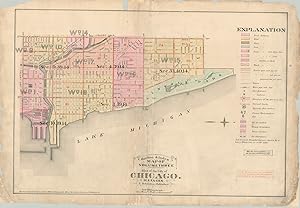
Outline & Index Map of Volume Three Atlas of the City of Chicago Index map to Volume III of Robinson's 1886 fire insurance atlas of Chicago.
Ańo de publicación: 1886
Librería: Curtis Wright Maps, Berwyn, IL, Estados Unidos de America
Miembro de asociación: ESA MWABA
Valoración del vendedor:
Condición: Good. This well-used map of Chicago's lakefront between the river and Lincoln Park was published in response to the devastating fire that rampaged through the city between October 8-10, 1871. Elisha Robinson, it's creator, was one of the numerous publishers who issued atlases specifically for the fire insurance industry. In order to properly assess risk, insurers needed information on building size, construction material, and the availability of water. Surveys were painstakingly performed, usually on foot, and the results are among the most complete snapshots of the city's physical makeup in the late 19th and early 20th centuries. This map was issued in Volume III of Robinson's Atlas of the City of Chicago in 1886 and served as a key and index to the rest of the tome. Though it shows a few individual details such as City Hall, the Water Works, railroads, and ward numbers, the information presented is a broad generalization when compared to each page of the atlas. As noted on the right side, the maps, in theory, outline every single building that existed at the time of publication. Though the blocks on the index are colored generically, individual footprints would be tinted according to their construction materials. Water lines, street elevation (which affects the flow), fire hydrants, and cisterns are also all noted. Sheet Width (in) 32.5 Sheet Height (in) 22.4 Condition Description Old and brittle paper formerly torn completely in several places and chipped in the corners. Repaired a number of times over the years, most recently with archival tape in numerous areas on the verso. Heavily soiled, with paper missing in several areas around the edges of the sheet.
-
![Imagen del vendedor de N 1/2 Section 31.40.14 [Chicago] The Chicago River's North Branch in the late 19th century. a la venta por Curtis Wright Maps](https://pictures.abebooks.com/inventory/md/md31695376371.jpg)
N 1/2 Section 31.40.14 [Chicago] The Chicago River's North Branch in the late 19th century.
Ańo de publicación: 1886
Librería: Curtis Wright Maps, Berwyn, IL, Estados Unidos de America
Miembro de asociación: ESA MWABA
Valoración del vendedor:
Condición: Fine. "This fabulously detailed map of several city blocks in Chicago's Wicker Park neighborhood was published in response to the devastating fire that rampaged through the city between October 8-10, 1871. Elisha Robinson, its creator, was one of the numerous publishers who issued atlases specifically for the fire insurance industry. In order to properly assess risk, insurers needed information on building size, construction material, and the availability of water. Surveys were painstakingly performed, usually on foot, and the results are among the most complete snapshots of the city's physical makeup in the late 19th and early 20th centuries. The map, in theory, outlines every single building that existed at the time of publication. Color was applied by stencil and shows the construction material of each structure; pink is brick, yellow is wood, brown is stone, and blue is iron. Crosses on a building footprint indicates its use as a stable, and thus likely to hold combustible materials. Water lines, street elevation (which affects the flow), fire hydrants, and cisterns are also all noted. The image is bounded by Fullerton, Western, Armitage and Clybourne Avenue. Along the river are numerous industrial facilities like a planing mill, brick yard, pump house, and barbed wire factory. The rest of the area is mostly plotted for residences, which become more concentrated and affluent (brick vs. wood construction) to the south and west. Many of the structures along Paulina were destroyed to accomodate the construction of the Kennedy Expressway. The map was issued as plate 28 in Volume IV of Robinson's Fire Insurance Atlas. Published in Chicago by Elisha Robinson in 1886. Sources: Newberry Library; Chicagology;" Sheet Width (in) 31.5 Sheet Height (in) 22 Condition Description Light soiling in the upper right and some darkening from the plate impression in the upper center. Faint wear and toning visible around the outer edges, consistent with age. Very good overall.
-
![Imagen del vendedor de S.W. 1/4 and Parts of N.W. 1/4 and S.E. 1/4 Section 30.40.14 [Chicago] The northern extent of Chicago prior further incorporations. a la venta por Curtis Wright Maps](https://pictures.abebooks.com/inventory/md/md31695378023.jpg)
S.W. 1/4 and Parts of N.W. 1/4 and S.E. 1/4 Section 30.40.14 [Chicago] The northern extent of Chicago prior further incorporations.
Ańo de publicación: 1886
Librería: Curtis Wright Maps, Berwyn, IL, Estados Unidos de America
Miembro de asociación: ESA MWABA
Valoración del vendedor:
Condición: Very Good. This fabulously detailed map of several city blocks at the most northern part of the Chicago city limits was published in response to the devastating fire that rampaged through the city between October 8-10, 1871. Elisha Robinson, its creator, was one of the numerous publishers who issued atlases specifically for the fire insurance industry. In order to properly assess risk, insurers needed information on building size, construction material, and the availability of water. Surveys were painstakingly performed, usually on foot, and the results are among the most complete snapshots of the city's physical makeup in the late 19th and early 20th centuries. In theory, every single building that existed at the time of publication is outlined within the borders of the map. Color was applied by stencil and shows the construction material of each structure; pink is brick, yellow is wood, brown is stone, and blue is iron. Crosses on a building footprint indicate its use as a stable, or otherwise likely to hold combustible materials. Water and sewer lines, street elevation (which affects the flow), fire hydrants, and cisterns are also all noted. The image is bounded by the north branch of the Chicago River, Western Avenue, and Fullerton Avenue. Adjacent townships of Jefferson and Lake View would be annexed by the city three years after publication. The area is largely vacant, with a handful of scattered houses on the plotted residential divisions and a few large industrial buildings near the river's edge. The largest has a set of team tracks leading to the lines of the Chicago and Northwestern Railroad. The map was issued as plate 29 from Volume IV of Robinson's Fire Insurance Atlas. Published in Chicago by Elisha Robinson in 1886. Sheet Width (in) 32.6 Sheet Height (in) 22.75 Condition Description "Moderately worn across the upper margin, including tape repairs, wrinkling, and several small tears. Slightly brittle paper is lightly toned, consistent with age, and shows a bit of wear elsewhere in the margins. One 1" tear, left side, has been repaired on the verso with archival tape.".
-

Outlines of the Science of Life; Which Treats Physiologically of Both Body and Mind; Designed Only for Philosophers and Other Candid Persons. To Which Are Added Essays on Other Subjects.
Publicado por Collins, New-York, 1829
Librería: Pride and Prejudice-Books, Ballston Lake, NY, Estados Unidos de America
Valoración del vendedor:
Libro Original o primera edición
Hardcover. Condición: Good. 1st Edition. First Edition. Original blue paper-covered boards and brown paper-covered spine. xix, 202 pp. plus advertisement. Includes William Robinson's article "On Dysentery," an article on lithotomy by Elisha North, an article on vaccination in Goshen, CT in 1800 by Elisha North, and an article on "The Rights of Anatomists" especially in Connecticut. Some paper loss on the spine, including the spine label, some cover staining, substantial foxing, Good. Folding plate present.
-
![Imagen del vendedor de E. 1/2 of S.W. 1/4 Section 4.39.14 [Chicago] "Chicago's rough patch - "Little Hell", then Cabrini-Green." a la venta por Curtis Wright Maps](https://pictures.abebooks.com/inventory/md/md31695373469.jpg)
E. 1/2 of S.W. 1/4 Section 4.39.14 [Chicago] "Chicago's rough patch - "Little Hell", then Cabrini-Green."
Ańo de publicación: 1886
Librería: Curtis Wright Maps, Berwyn, IL, Estados Unidos de America
Miembro de asociación: ESA MWABA
Valoración del vendedor:
Condición: Fine. This fabulously detailed map of several city blocks in Chicago's Cabrini-Green neighborhood was published in response to the devastating fire that rampaged through the city between October 8-10, 1871. Elisha Robinson, its creator, was one of the numerous publishers who issued atlases specifically for the fire insurance industry. In order to properly assess risk, insurers needed information on building size, construction material, and the availability of water. Surveys were painstakingly performed, usually on foot, and the results are among the most complete snapshots of the city's physical makeup in the late 19th and early 20th centuries. In theory, every single building that existed at the time of publication is outlined within the borders of the map. Color was applied by stencil and shows the construction material of each structure; pink is brick, yellow is wood, brown is stone, and blue is iron. Crosses on a building footprint indicate its use as a stable, or otherwise likely to hold combustible materials. Water and sewer lines, street elevation (which affects the flow), fire hydrants, and cisterns are also all noted. The image is bounded by Division Street, Sedgwick Street, Chicago Avenue, and Larrabee Street and shows a relatively impoverished, working-class neighborhood. Wooden buildings are densely clustered, often two to a lot, and nearby industries would have been constant sources of odors and noise. Examples include a large laundry, wagon manufacturer, malt house, and varnish factory. A large wooden hall and several Swedish churches allude to the immigrant composition of the neighborhood. In the late 19th century, the area was known as 'Little Hell' from a large gas furnace located just west of the map. It played a pivotal role in Chicago's early gangster years as the original location of Little Sicily, and would eventually become home to the city's most notorious housing project, Cabrini-Green. The map was issued as plate 16 from Volume III of Robinson's Fire Insurance Atlas. Published in Chicago by Elisha Robinson in 1886. Sheet Width (in) 32.75 Sheet Height (in) 22.4 Condition Description Several dirty fingerprints visible around the outer edges of the image and margin. Old tabs on either side and slightly brittle paper has a few small chips and tears along the outside. Very good overall.
-
![Imagen del vendedor de South 1/2 of Section 3.1.40.14 [Chicago] The heart of Wicker Park, almost 150 years ago. a la venta por Curtis Wright Maps](https://pictures.abebooks.com/inventory/md/md31695374408.jpg)
South 1/2 of Section 3.1.40.14 [Chicago] The heart of Wicker Park, almost 150 years ago.
Ańo de publicación: 1886
Librería: Curtis Wright Maps, Berwyn, IL, Estados Unidos de America
Miembro de asociación: ESA MWABA
Valoración del vendedor:
Condición: Fine. "This fabulously detailed map of several city blocks in Chicago's Wicker Park/Bucktown neighborhood was published in response to the devastating fire that rampaged through the city between October 8-10, 1871. Elisha Robinson, its creator, was one of the numerous publishers who issued atlases specifically for the fire insurance industry. In order to properly assess risk, insurers needed information on building size, construction material, and the availability of water. Surveys were painstakingly performed, usually on foot, and the results are among the most complete snapshots of the city's physical makeup in the late 19th and early 20th centuries. The map, in theory, outlines every single building that existed at the time of publication. Color was applied by stencil and shows the construction material of each structure; pink is brick, yellow is wood, brown is stone, and blue is iron. Crosses on a building footprint indicate its use as a stable, and thus likely to hold combustible materials. Water lines, street elevation (which affects the flow), fire hydrants, and cisterns are also all noted. The image is bounded by Western, Armitage, Ashland, and North Avenues. Only a small portion of the streets are paved, concentrated in the southeast and indicated by a faint orange tint. The neighborhood was largely ethnic and working class at the time of publication, with several commercial corridors and access to at least one horse-drawn street railway. Two public schools, several churches, a sash & blind factory, and large stable company are also shown. Still, large tracts of empty land remain adjacent to Milwaukee Avenue, and the area is considerably less dense than what can be seen today. The map was issued as plate 27 in Volume IV of Robinson's Fire Insurance Atlas of the City of Chicago. Published in Chicago by Elisha Robinson in 1886. Source." Sheet Width (in) 32.75 Sheet Height (in) 22.6 Condition Description The outer edges are lightly toned and have a few small tears. Light spotting also confined to the margins and near the '24' in the lower key. Creased along vertical centerfold, but very good overall.
-
![Imagen del vendedor de W. 1/2 of N.W. 1/4 Section 17.39.14 [Chicago] The West Loop in 1886. a la venta por Curtis Wright Maps](https://pictures.abebooks.com/inventory/md/md31695375330.jpg)
W. 1/2 of N.W. 1/4 Section 17.39.14 [Chicago] The West Loop in 1886.
Ańo de publicación: 1886
Librería: Curtis Wright Maps, Berwyn, IL, Estados Unidos de America
Miembro de asociación: ESA MWABA
Valoración del vendedor:
Condición: Fine. This fabulously detailed map of several city blocks in Chicago's West Loop neighborhood was published in response to the devastating fire that rampaged through the city between October 8-10, 1871. Elisha Robinson, its creator, was one of the numerous publishers who issued atlases specifically for the fire insurance industry. In order to properly assess risk, insurers needed information on building size, construction material, and the availability of water. Surveys were painstakingly performed, usually on foot, and the results are among the most complete snapshots of the city's physical makeup in the late 19th and early 20th centuries. In theory, every single building that existed at the time of publication is outlined within the borders of the map. Color was applied by stencil and shows the construction material of each structure; pink is brick, yellow is wood, brown is stone, and blue is iron. Crosses on a building footprint indicate its use as a stable, or otherwise likely to hold combustible materials. Water and sewer lines, street elevation (which affects the flow), fire hydrants, and cisterns are also all noted. The image is bounded by Madison, Loomis, Harrison, and Ashland, and shows a largely affluent neighborhood with numerous brick buildings, many of which show stone facades. Buildings of interest include a natatorium, the Salvation Army Building, and the Church of the Epiphany. The last was completed the year prior to publication and was recently converted into an event space. It's one of the few buildings that remain today, as the area is largely occupied by Skinner Park, Whitney Young High School, Chicago Police Training Academy, and the Eisenhower Expressway. The map was issued as plate 8 from Volume IV of Robinson's Fire Insurance Atlas. Published in Chicago by Elisha Robinson in 1886. Sheet Width (in) 32.75 Sheet Height (in) 23.5 Condition Description Slightly brittle paper has a few small tears around the outer edges, chipped corners, and other marginal wear. Lightly toned, consistent with age, but remains in very good condition overall.
-
![Imagen del vendedor de E. 1/2 of N.E. 1/4 Section 4.39.14 [Chicago] A portion of Chicago's Gold Coast neighborhood from the late 19th century. a la venta por Curtis Wright Maps](https://pictures.abebooks.com/inventory/md/md31695378022.jpg)
E. 1/2 of N.E. 1/4 Section 4.39.14 [Chicago] A portion of Chicago's Gold Coast neighborhood from the late 19th century.
Ańo de publicación: 1886
Librería: Curtis Wright Maps, Berwyn, IL, Estados Unidos de America
Miembro de asociación: ESA MWABA
Valoración del vendedor:
Condición: Very Good. This fabulously detailed map of several city blocks in Chicago's Gold Coast neighborhood was published in response to the devastating fire that rampaged through the city between October 8-10, 1871. Elisha Robinson, its creator, was one of the numerous publishers who issued atlases specifically for the fire insurance industry. In order to properly assess risk, insurers needed information on building size, construction material, and the availability of water. Surveys were painstakingly performed, usually on foot, and the results are among the most complete snapshots of the city's physical makeup in the late 19th and early 20th centuries. In theory, every single building that existed at the time of publication is outlined within the borders of the map. Color was applied by stencil and shows the construction material of each structure; pink is brick, yellow is wood, brown is stone, and blue is iron. Crosses on a building footprint indicate its use as a stable, or otherwise likely to hold combustible materials. Water and sewer lines, street elevation (which affects the flow), fire hydrants, and cisterns are also all noted. The image is bounded by North Avenue, State Street, Division Street, and LaSalle Avenue and is subtitled the Bronson Addition - likely after Arthur Bronson, a New York financier and early investor in Chicago during the 1830s and 40s. The affluent neighborhood is comprised of brick houses on relatively spacious lots with paved streets. Stone facades on building blocks likely indicate mixed commercial and residential use, with numerous additions and sub-divisions labeled. The area includes a Baptist Church, Summer Garden, and Malt House. The last was located near the site on which the Playboy Mansion would ultimately be built. The map was issued as plate 21 from Volume III of Robinson's Fire Insurance Atlas. Published in Chicago by Elisha Robinson in 1886. Sheet Width (in) 32.5 Sheet Height (in) 22.7 Condition Description Moderately toned and brittle paper, with soiled margins and a few small spots within the image. Minor discoloration along the vertical centerfold and dark spots from former tabs on either side. Remains in good condition, or slightly better, overall.
-
Robinson's Atlas of the City of Newark New Jersey (Volume 3 of 3 only)
Publicado por Newark, Newark, 1927
Librería: High Ridge Books, Inc. - ABAA, South Deerfield, MA, Estados Unidos de America
Miembro de asociación: ABAA ESA ILAB SNEAB
Valoración del vendedor:
Original buckram, fine condition. Volume three only, covering the southeastern portion of the city. 35 double-page maps, including index map. Full color. LeGear L2377.
-
![Imagen del vendedor de W. 1/2 of S.W. 1/4 Section 3.39.14 [Chicago] Map of Haymarket Square published the same year as its infamous riot. a la venta por Curtis Wright Maps](https://pictures.abebooks.com/inventory/md/md31695375325.jpg)
W. 1/2 of S.W. 1/4 Section 3.39.14 [Chicago] Map of Haymarket Square published the same year as its infamous riot.
Ańo de publicación: 1886
Librería: Curtis Wright Maps, Berwyn, IL, Estados Unidos de America
Miembro de asociación: ESA MWABA
Valoración del vendedor:
Condición: Fine. "This fabulously detailed map of several city blocks in Chicago's West Loop neighborhood was published in response to the devastating fire that rampaged through the city between October 8-10, 1871. Elisha Robinson, its creator, was one of the numerous publishers who issued atlases specifically for the fire insurance industry. In order to properly assess risk, insurers needed information on building size, construction material, and the availability of water. Surveys were painstakingly performed, usually on foot, and the results are among the most complete snapshots of the city's physical makeup in the late 19th and early 20th centuries. This map, in theory, outlines every single building that existed at the time of publication. Color was applied by stencil and shows the construction material of each structure; pink is brick, yellow is wood, brown is stone, and blue is iron. Crosses on a building footprint indicate its use as a stable, or otherwise likely to hold combustible materials. Water and sewer lines, street elevation (which affects the flow), fire hydrants, and cisterns are also all noted. The image is bounded by Halsted, Madison, Jefferson and Kinzie Streets, with a heavy concentration of rail tracks and Milwaukee Avenue near the top of the sheet. Like today, the area was of mixed use, though on an entirely different scale. Large freight depots (including one for Milwaukee Beer) parallel the tracks, with several sawmills and lumber yards nearby. Immediately below, a wide belt of manufacturing included an iron foundry, wagon manufactory, flour mill, bakery, machine shop, and other industries. Haymarket Square was located along Randolph Street between Halsted and Des Plaines. It was a significant commercial corridor, with a produce market in the center of the street and numerous shops on either side. The Square was also the site of the Haymarket Riot, which took place in May of 1886, the same year the map was published. During a peaceful labor protest in support of an eight-hour workday, an alleged anarchist threw a bomb at police working to disperse the crowd. The ensuing eruption of violence resulted in the deaths of seven police (mostly friendly fire) and dozens of civilian casualties. Many of the wounded were carried to the nearby police station, labeled on the map. As one travels further south from Haymarket, stone exteriors, luxury accommodations, and cultural opportunities become more commonplace. The Lyceum Theater, Prairie State Trust Company and Bank, and St. Denis Hotel are all labeled, with the last two bearing the characteristic markings of a luxury facade. The map was issued as plate 4 from Volume III of Robinson's Fire Insurance Atlas. Published in Chicago by Elisha Robinson in 1886. Source." Sheet Width (in) 22.5 Sheet Height (in) 32.75 Condition Description Moderately soiled in the outer margins and in several places within the image, though not as to distract. Creased along vertical centerfold and a few small chips and tears from paper that has become somewhat brittle from age. Remains in very good condition overall.
-
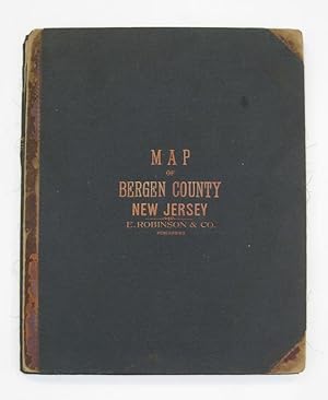
Map of Bergen County with a Portion of Passaic Co.; Compiled from the Geological Survey of New Jersey, Official Maps Private Plans and Actual Surveys by and under the direction of E. Robinson
Publicado por E. Robinson & Co, New York, 1902
Librería: Argosy Book Store, ABAA, ILAB, New York, NY, Estados Unidos de America
Miembro de asociación: ABAA ILAB
Valoración del vendedor:
Mueller, A.H. Ilustrador. Wall map. Color lithograph with hand coloring. Library format in four pieces, mounted on three boards as issued, 18 x 14 1/2 inches, if joined, 53" x 67.5". This impressive map of Bergen County, New Jersey depicts the county's townships and boroughs in remarkably vivid colors. A short newsprint text praising the map has been glued onto its lower right-hand portion. The map is highly informational and depicts railroads both electric and steam, public roads, and elevations. The index also includes churches, schools, cemeteries, and meadows. The map is in good condition, with some tears along the folds, a crease in the lower left portion, and minor browning throughout. The coloring, however, remains exceptionally brilliant. Elisha Robinson (1832-1912) published a number of detailed, general purpose maps, including comprehensive atlases of Kings County, New York and Essex County, New Jersey. This library edition was printed in Philadelphia by A.H. Mueller.
-
Robinson's Atlas of Norfolk County Massachusetts Fire insurance atlas of Norfolk County from 1888.
Ańo de publicación: 1888
Librería: Curtis Wright Maps, Berwyn, IL, Estados Unidos de America
Miembro de asociación: ESA MWABA
Valoración del vendedor:
Condición: Fine. "Fire insurance maps date from 1867 to the present and depict the commercial, industrial, and residential sections of tens of thousands of cities in the United States, Canada, and Mexico. Maps were designed to assist fire insurance agents to determine the degree of hazard for a property. The maps show the size, shape, and construction of dwellings, commercial buildings, and factories as well as fire walls, locations of windows and doors, sprinkler systems, and types of roofs. The maps also indicate widths and names of streets, property boundaries, building use, house and block numbers, and location of fire hydrants. Today, these maps serve as valuable resources for historians, planners, preservationists, genealogists and urban geographers." - University of Wisconsin-Milwaukee. This incredibly detailed atlas of Norfolk County, Massachusetts was published in New York by Elisha Robinson in 1888. It provides a comprehensive overview of the region's physical composition in the midst of the Gilded Age. Each of the double-page maps displays a wealth of information about the infrastructure, buildings, lots, and transportation routes available to local residents at the time. Source: University of Wisconsin-Milwaukee" Sheet Width (in) 15.5 Sheet Height (in) 20.25 Condition Description "Rebound in new quarter black leather and black cloth with gilt accents. A portion of the original embossed cover is adhered to the front board. New endpapers and flyleafs. Title page is heavily soiled and has the left margin restored and reinforced. Contents show scattered wear and soiling in the margins, consistent with age and use. A few small edge tears are confined to the margins, and there are a handful of spots within the image on a few sheets. Complete, with 45 double page plates (including the outline map) featuring original hand color. An old photograph of a map of Dedham, about 11" x 13.5" has been tipped into the binding immediately before the respective city plan. Very good overall".
-
New York City; Outline & Index Map of New York City
Publicado por E. Robinson Co, New York, 1885
Librería: Argosy Book Store, ABAA, ILAB, New York, NY, Estados Unidos de America
Miembro de asociación: ABAA ILAB
Valoración del vendedor:
framed. Map. Color lithograph. Map measures 18 x 26 inches. Framed in green and gold, outside dimensions measure 24 1/2 x 34 1/4 inches. E. Robinson Company: 1885. Rare index map of New York City showing Manhattan up to 109 Street. Includes part of New Jersey, Brooklyn and Governors island, Ellis Island and Bedloe's island which notes Bartholdi's Statue of Liberty location (unveiled in 1886).The index lists the type of building structures in New York City. Train and ferry routes included. Elisha Robinson (1832-1912) published a number of detailed, real estate maps, including comprehensive atlases of Kings County, New York and Essex County, New Jersey.