
Importe total (1 artículo artículos):
Destino del pedido:

ORDNANCE SURVEY; WAR OFFICE (12 resultados)
Ir a los resultados principales
Tipo de artículo
- Todo tipo de artículos
- Libros (3)
- Revistas y publicaciones
- Cómics
- Partituras
- Arte, grabados y pósters
- Fotografías
- Mapas (9)
-
Manuscritos y
coleccionismo de papel
Condición
- Todo
- Nuevos
- Antiguos o usados
Encuadernación
Más atributos
- Primera edición (1)
- Firmado
- Sobrecubierta
- Con imágenes del vendedor (8)
- Sin impresión bajo demanda
Ubicación del vendedor
Valoración de los vendedores
-

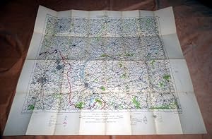
Helmsdale (Ordnance Survey of Scotland Popular edition sheet 17 War Revision 1940)
Publicado por War Office/Ordnance Survey, 1940
Librería: Simply Read Books, Boat Of Garten, Reino Unido
Valoración del vendedor:

Libro
Unbound. Condición: Good. No Jacket. 1940 War Office/Ordnance Survey folded coloured paper linen-backed map, Ordnance Survey of Scotland Popular edition sheet 17 Caithness and Sutherland War Revision 1940, unmounted sheet; ref W O 10,000/40 5,000/5/41; 56 centimetres h by 76 w; scale one inch to one statute mile; folds 1 x 5; stamped "may be used along with 1932 Popular edition No significant change"; good clean copy, listed as good because the edges have been cut so some of the legend has been lost, the map itself is complete and in very good condition; UK dealer, immediate dispatch.
-
France: St. Quentin 18, scale 1/100,000
Publicado por War Office, London, 1916
Librería: Cotswold Internet Books, Cheltenham, Reino Unido
Valoración del vendedor:
Original o primera edición
1st ed. Linen backed folding map. Owner's name on front 'cover' dated 1917. Front & back cover foxed; map clean & tight. General Staff no.2364 Used - Very Good. VG folded map.
-
Soft cover. Condición: Very Good. Photo-etched at the Ordnance Survey Office, Southampton, 1912 Ilustrador. Near fine condition, canvas backed scale 1/100,000or 1 inch to 1.58 miles or 1 cm to 1km, coloured. [QP].
-
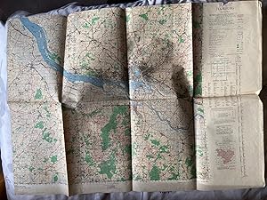
Hamburg: A collection of 4 maps. 1 x Ordnance Survey Sheet L4, 1943; 2 x Town Plans, War Office, 1944; 1 x undated Public Transport Map
Publicado por Ordnance Survey/War Office, London, 1943
Mapa
No Binding. Condición: Very Good. No Jacket. A collection of 4 maps of Hamburg, in remarkably good condition for their age: No 1. Ordnance Survey, Central Europe,1st Edition, Hamburg, Colour, Sheet L4, 1943, 85 cm x 65cm; in very good clean condition, folds all intact apart narrow fold at top which has slight erosion to right hand side in key section not in map. Nos.2 & 3, 2 sheets, covering Hamburg, of War Office Town Plans. dated 1944, each sheet110 cm x 85 cm; both sheets extremely bright and clean, no damage at all. 4. small A4 (Approx) size map of public transport routes in and around Hamburg, in German, undated and with no publishing statement, clean an intact, routes shown in red and black.
-
[Map] Main Trunk Air Routes 1933 (O.R. 501)
Publicado por Printed at the War Office, London, 1934
Mapa
Soft cover. Condición: Near Fine. Colour folding paper map of the World 88x58cm. Near fine, neatly folded with some spotting. This is credited to the Ordnance Survey (1926), printed at the War Office (1934). It shows actual and proposed air routes and rail connections, indicating the nationality of each with an alphabetical key from Afghan to Venezuelan.
-
Map: Somaliland - Geographical Section General Staff GSGS No. 2871.
Publicado por War Office, Edward Stanford, London, 1926
Mapa
Soft cover. Condición: Very Good. Colour folding map of Somaliland (Africa 1:2,000,000 / North C38-39 / B38-39) with inset of Socotra, dissected into 21 sections and mounted on to linen 80 x 58cm, folding down into pebble-grained wraps with Stanford's title label 12 x 19cm (hand-titled "Somalilands / Abyssinia), with small Stanford sticker. Paper very good, lightly tanning, with faint pencil notation to bottom margin and some quite neat underlining in black. Some marks to the linen. Compiled and drawn at the War Office (WO), heliographed at the Ordnance Survey (OS) in 1926, and printed at WO in 1926. Colour tinted for heights. Note stamped in red ink to the bottom margin: "The boundaries of ABYSSINIA with ITALIAN and FRENCH territories have not been demarcated". This map marks out the boundaries with Italian Somalia, and has strategic importance. In 1924 the British ceded northern Jubaland to the Italians in return for their support during the Great War, and it was duly incorporated into Italian Somaliland in 1926. In the same year, Britain attempted to force Abyssinia to accept construction of a major water project intended to irrigate the Anglo-Egyptian Sudan, while the Italians attempted to exploit local railway links for commercial gain. In response to Ras Tafari's appeal to the League of Nations, the British scheme was dropped.
-
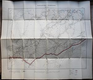
Ordnance Survey Military Map of German East Africa / Tanganyika Territory: Massassi (Series: GSGS 3026, Sheet: G6).
Publicado por Ordnance Survey, London, 1916
Mapa
No Binding. Condición: Near Fine. Great War-era cloth / linen backed folding military map featuring the territory south of Kilwa, stretching to Portuguese East Africa (now Mozambique) in the south, and inland to Mlahi. Coloured, with cover details written in pencil on the front surface. Scale 1 : 300,000. Size unfolded = 85 x 71.5cm. Map near fine, allowing for light tanning to the cloth and paper. Please check my other listings for adjoining sheets and related series.
-
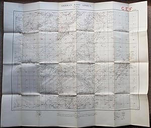
Ordnance Survey Military Map of German East Africa: Mohoro (Series: GSGS 3026, Sheet: E6).
Publicado por Ordnance Survey, London, 1916
Mapa
No Binding. Condición: Very Good. Great War-era cloth / linen backed folding military map featuring Matumbi in the south, stretching to Usaramo in the north, and the Swahili coast with the island of Mafia to the east. Coloured, with cover details written on the front surface. Scale 1 : 300,000. Size unfolded = 85.5 x 71cm. Map very good allowing for tanning to the cloth and paper, and long narrow holes to a couple of intersections. Signs of military use, overprinted with pink grid, red letters and numbers. Letters GEF in red in top margin. Please check my other listings for adjoining sheets and related series.
-
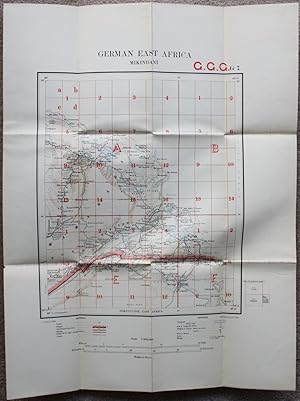
Ordnance Survey Military Map of German East Africa: Mikindani (Series: GSGS 3026, Sheet: G7).
Publicado por Ordnance Survey, London, 1916
Mapa
No Binding. Condición: Near Fine. Great War-era cloth / linen backed folding military map featuring the Swahili Coast south east of Kilwa and Massassi stretching down to Portuguese East Africa (now Mozambique). Coloured, with cover details on the front surface. Scale 1 : 300,000. Size unfolded = 40 x 53cm. Map near fine, allowing for light tanning to the cloth and paper, and a couple small holes at the intersections. Signs of military use, overprinted with pink grid, red letters and numbers. Letters GGG in red in top margin. Please check my other listings for adjoining sheets and related series.
-
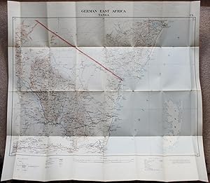
Ordnance Survey Military Map of German East Africa: Tanga / with Usambara and Swahili Coast - Mombasa, Pangani, Pemba etc (Series: GSGS 3026, Sheet: C6).
Publicado por War Office, London, 1916
Mapa
No Binding. Condición: Very Good. Great War-era linen backed folding military map of Tanga, featuring the stretch of the Swahili coast from Mombasa down to Pangani, taking in the island of Pemba, and Usambara inland. Coloured, with cover details written on the front surface. Scale 1 : 300,000. Size unfolded 79 x 73cm. Map very good allowing for light tanning to the cloth and paper, and small holes at a couple of the intersections. Very wide side margins have been trimmed, resulting in part of covers missing, not affecting map. Please check my other listings for adjoining sheets and related series.
-
Trench Map Wervicq 28 S.E.1 Edition 6 A 1: 10,000 (30-8-17)
Publicado por Ordnance Survey, 1917
Librería: WORLD WAR BOOKS, TUNBRIDGE WELLS, Reino Unido
Miembro de asociación: PBFA
Valoración del vendedor:
Libro
Soft cover. Condición: Very Good. No Jacket. Rare original Trench Map, titled Wervicq. The classic 1:10,000 scale, standard size, linen folding with index to adjoining sheets to cover. 28 S.E. 1, Edition 6 A. corrected to 30-8-1917. Important map showing considerable coverage of German trenches in red. Map covers area from Potsdam House and Potsdam Farm im top left hand corner, just north of Ypres canal and railway which run South East. Other areas covered include Zandvoorde, Houthem, Tenbrielen down to Wervicq. Very modest age wear, overall very nice example of a rare map.
-
Hardcover. Condición: Fine. 3rd Edition. Colour map 76x65cm mounted on linen and folded into a gilt-titled burgundy cloth case 18x28cm. Fine. This is the 3rd edition 1945, reproduced by the Ordnance Survey from MDR I/12054 1944, with air information from RAF Middle East HQ dated Dec 1944. About centred on the Strait of Hormuz, this covers the Arabian side of the Arabian / Persian Gulf and Gulf of Oman from Qantar to Al Qasbiyat (naming Abu Dhabi, Dubai, Sharjah, Ajman, Umm al Quwain, Ras al Khaimah, Fujairah and Independent Oman) and inland to Buraimi and Hafit. On the Iranian side it covers the Shibkuh Coast to Ras Tank, and inland to the north of Lar, with steamer service routes indicated from Bandar Abbas to Bushire and Muscat. Extensive geographical information is supported by Arabic-English and Iranian-English glossaries.

![Imagen del vendedor de [Map] Main Trunk Air Routes 1933 (O.R. 501) a la venta por Dendera](https://pictures.abebooks.com/inventory/md/md31579095493.jpg)
![Imagen del vendedor de [Map] Asia 1/1M, GSGS 2555, NG-40, Bandar Abbas a la venta por Dendera](https://pictures.abebooks.com/inventory/md/md31762787128.jpg)