Importe total (1 artículo artículos):
Destino del pedido:

LOUISIANA MAP (7 resultados)
Ir a los resultados principales
Tipo de artículo
- Todo tipo de artículos
- Libros (4)
- Revistas y publicaciones
- Cómics
- Partituras
- Arte, grabados y pósters
- Fotografías
- Mapas (3)
-
Manuscritos y
coleccionismo de papel
Condición
- Todo
- Nuevos
- Antiguos o usados
Encuadernación
- Todo
- Tapa dura
- Tapa blanda (2)
Más atributos
- Primera edición (1)
- Firmado
- Sobrecubierta
- Con imágenes del vendedor (6)
- Sin impresión bajo demanda
Ubicación del vendedor
Valoración de los vendedores
-

Louisiana.
Publicado por Dodd, Mead & Co., [New York], 1890
Librería: Jeffrey H. Marks, Rare Books, ABAA, Rochester, NY, Estados Unidos de America
Miembro de asociación: ABAA ILAB
Valoración del vendedor:

8 x 10 inches. Creased vertically where folded; otherwise fine.
-
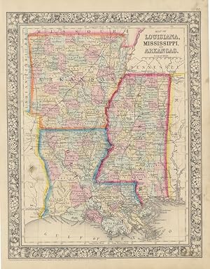
Map of Louisiana, Mississippi, and Arkansas
Publicado por S. Augustus Mitchell, Jr., New York, 1860
Librería: Main Street Fine Books & Mss, ABAA, Galena, IL, Estados Unidos de America
Miembro de asociación: ABAA ILAB MWABA
Valoración del vendedor:
Mapa
Folio (12Ľ" X 15", image area 10 3/4" X 13˝"). Hand colored. Very good. Minor age toning and bit of soiling, mainly about edges. A bold and nicely colored map of this southern trio, from the 1864 edition of "Mitchell's New General Atlas, Containing Maps of the Various Countries of the World, Plans of Cities, Etc." Delicately colored and with handsome decorative border.
-
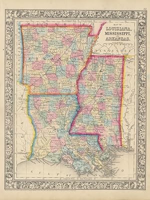
Map of Louisiana, Mississippi, and Arkansas
Publicado por S. Augustus Mitchell, Jr., New York, 1860
Librería: Main Street Fine Books & Mss, ABAA, Galena, IL, Estados Unidos de America
Miembro de asociación: ABAA ILAB MWABA
Valoración del vendedor:
Mapa
Folio (12Ľ" X 15", image area 10 3/4" X 13˝"). Hand colored. Very good. Light age toning only. Bold, bright map of this trio of states, from the 1864 edition of "Mitchell's New General Atlas, Containing Maps of the Various Countries of the World, Plans of Cities, Etc." Handsomely colored, with fine decorative border.
-
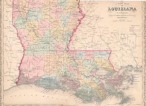
A New Map of Louisiana
Publicado por Charles Desilver, Philadelphia, 1857
Librería: Main Street Fine Books & Mss, ABAA, Galena, IL, Estados Unidos de America
Miembro de asociación: ABAA ILAB MWABA
Valoración del vendedor:
Mapa
17Ľ" X 13 3/4" (image 16" X 12 3/4"). Hand colored. Near fine. Faint age toning. Drawn by J.L. Hazzard, this superb, delicately hand colored map features a large ornamental border.
-
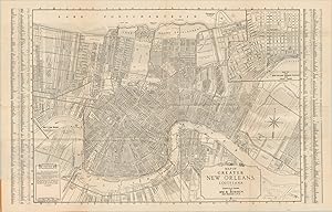
Map of Greater New Orleans Louisiana New Orleans in 1934 - a battleground between Huey Long and local political interests.
Ańo de publicación: 1934
Librería: Curtis Wright Maps, Berwyn, IL, Estados Unidos de America
Miembro de asociación: ESA MWABA
Valoración del vendedor:

Condición: Fine. This spectacularly detailed city plan of New Orleans, Louisiana was created and published locally by William E. Boesch in 1934. Delicate labels identify a wealth of information about 'La Vieux Carre' in the midst of the Great Depression - noting transportation options, major landowners, prominent businesses, schools, recreational opportunities, military installations, and much more. Numerous industries are shown along the banks of the Mississippi River, reflecting the city's primary avenue for economic development. The map is affixed to a guidebook of the city that provides a street index, a map of the commercial district, and lists of places of interest. Also included is a separately printed 'Map of the Business District of New Orleans' (also by Boesch) that labels over fifty different locations in the downtown area. Sheet Width (in) 34 Sheet Height (in) 21.75 Condition Description Pocket map folded into 24 segments and affixed to original yellow paper wraps. Covers show light wear and some rust along the staples, which bind an 18 pp. guide to the city. The map shows some wrinkling and creasing along fold lines, and one or two small holes at fold intersections. Includes a separate map of downtown New Orleans. Very good overall.
-
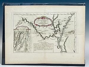
Suite du Cours du Fleuve St. Louis depuis la Rivi?re d'Iberville jusq'? celle des Yasous, et les parties connues de la Rivi?re Rouge et la Rivi?re Noire
Publicado por France, 1764
Librería: Vintage Books and Fine Art, Oxford, MD, Estados Unidos de America
Valoración del vendedor:
Original o primera edición
Condición: Very Good. Bellin, Jacques Nicolas Ilustrador. 1st Edition. Quarto. A beautiful 18th-century copperplate engraving from Bellin's Le Petit Atlas Maritime, Paris, 1747-64, with contemporary hand coloring. In addition to navigation of the Mississippi River, between the Iberville and the Yazoo, this map depicts a large section of the Red River, all the way to Natchitoches, and then depicts the road south to Adayes, the Spanish Presidio of Texas, a very early mention of Texas. In vignette in the lower left is a map of the French Fort St Jean and surrounding region while the lower center features a detailed description of the Red River in French. Original vertical fold line with later horizontal fold line. Wide margins. The image measures 14 1/2" X 9" while the sheet measures 17 3/8" X 12 1/2". Overall a very desirable piece of Louisiana history from French occupation, perfect for framing and display!.
-
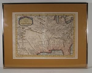
Carte de la Floride, de la Louisiane et Pays Voisins pour servir ŕ l'Histoire générale des Voyages 1757
Publicado por Paris, 1757
Aucune reliure. Condición: Trčs bon. Carte originale de Bellin, coloriée ŕ la main, publiée dans l' "Histoire générale des Voyages" de Prévost. Dimensions de la carte : 23 x 32.5 cm. Dimensions du cadre : 33.5 x 44 cm. Encadrement récent de qualité. "Cartographe du Roi", Jacques-Nicolas Bellin est reconnu pour ses cartes de l'Amérique du Nord. Oeuvre encadrée.