Importe total (1 artículo artículos):
Destino del pedido:

KEULEN, JOHANNES VAN (114 resultados)
Ir a los resultados principales
Tipo de artículo
- Todo tipo de artículos
- Libros (51)
- Revistas y publicaciones
- Cómics
- Partituras
- Arte, grabados y pósters (20)
- Fotografías
- Mapas (43)
-
Manuscritos y
coleccionismo de papel
Condición
Encuadernación
Más atributos
- Primera edición (4)
- Firmado
- Sobrecubierta
- Con imágenes del vendedor (92)
- Sin impresión bajo demanda (113)
Gastos de envío gratis
Ubicación del vendedor
Valoración de los vendedores
-
![Imagen del vendedor de Verhandeling der zee-horenkens en zee-gewassen in en omtrent Amboina en de nabygelegen eilanden, [LeatherBound] a la venta por True World of Books](https://pictures.abebooks.com/inventory/md/md31533062685.jpg)
Verhandeling der zee-horenkens en zee-gewassen in en omtrent Amboina en de nabygelegen eilanden, [LeatherBound]
Ańo de publicación: 2023
Libro Impresión bajo demanda
LeatherBound. Condición: New. LeatherBound edition. Condition: New. Reprinted from 1754 edition. Leather Binding on Spine and Corners with Golden leaf printing on spine. Bound in genuine leather with Satin ribbon page markers and Spine with raised gilt bands. A perfect gift for your loved ones. NO changes have been made to the original text. This is NOT a retyped or an ocr'd reprint. Illustrations, Index, if any, are included in black and white. Each page is checked manually before printing. As this print on demand book is reprinted from a very old book, there could be some missing or flawed pages, but we always try to make the book as complete as possible. Fold-outs, if any, are not part of the book. If the original book was published in multiple volumes then this reprint is of only one volume, not the whole set. Sewing binding for longer life, where the book block is actually sewn (smythe sewn/section sewn) with thread before binding which results in a more durable type of binding. Pages: 124 Language: Dutch.
-

Linee di costa: La cote d'Espagne de Malgue jusques ? Modril.
Publicado por Francia,, 1735
Librería: libreria antiquaria perini Sas di Perini, Verona, VR, Italia
Miembro de asociación: ALAI ILAB
Valoración del vendedor:

Arte / Grabado / Póster
Silografia di mm 90x240. Buon esemplare, con bruniture, tracce di umidit? e margini frastagliati.
-
Linee di costa: aussi de Barbarie jusques ? l'Isle de Tabarque, les cotes entre le Cap St. Martin & le Cap Creos.
Publicado por Amsterdam,, 1700
Librería: libreria antiquaria perini Sas di Perini, Verona, VR, Italia
Miembro de asociación: ALAI ILAB
Valoración del vendedor:
Arte / Grabado / Póster
Silografia intervalla a testo per uno specchio di stampa complessivo di mm 185x240. Ben conservato, con bruniture e tracce di umidit?.
-

Zee-Atlas.
ISBN 10: 3534216687ISBN 13: 9783534216680
Librería: SKULIMA Wiss. Versandbuchhandlung, Westhofen, Alemania
Valoración del vendedor:
Libro
De grootie nieuwe vermeerderde Zee-Atlas ofte Water-Werelt: vertoonende in sigh alle de Zee-Kusten des Aardtryks. Reprint der Ausgabe Amsterdam 1685. Ein Meilenstein der See-Kartographie. Mit einem Vorwort von Imre Josef Demhardt und einer Übersetzung der niederländischen Einleitung von Sigrid Barthel. Karten und Originaltexte sind auf etwa 88% verkleinert. Faksimiletext niederländisch, Einleitung deutsch. Der Nachdruck macht ein Prachtwerk der niederländischen Seekarten des ausgehenden 17. Jahrhunderts zugänglich, das auch ein beredtes Zeugnis seiner Zeit darstellt. Die wirtschaftliche und kulturelle Dynamik der niederländischen Provinzen Spaniens ließen deren bürgerlich-protestantischen Freiheitskampf erfolgreich enden und in das "goldene Zeitalter" der republikanischen Generalstaaten einmünden. Bis ins 18. Jahrhundert waren deren handeis- und kunstsinnige Bürger führend im Seehandel und damit auch in der Kartenkunst, mit Amsterdam als dem bedeutendsten Zentrum der nautischen Kartographie. Auf 555 Exemplare limitierte Lederausgabe. 104 Seiten mit 88 farbigen Faksimiletafeln, Großformat 50 x 29 cm, Leder in Schuber (Wissenschaftliche Buchgesellschaft 2008) leichte Lagerspuren, Schuber beschädigt 2725 g. Sprache: de, nl.
-
Linee di costa: Isles d'Yvique, Majorque & Minorque, les cotes entre le Cap St. Martin & le Cap Creos.
Publicado por Amsterdam,, 1700
Librería: libreria antiquaria perini Sas di Perini, Verona, VR, Italia
Miembro de asociación: ALAI ILAB
Valoración del vendedor:
Arte / Grabado / Póster
Silografia intervalla a testo per uno specchio di stampa complessivo di mm 380x240. Raffigura le coste delle Baleari e della Catalogna. Ben conservato, con bruniture e tracce di umidit?.
-
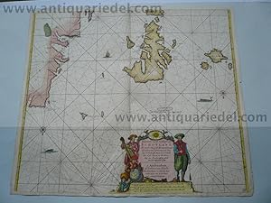
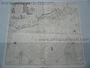
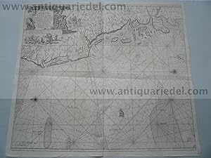
Antique chart of the Channel: The Dover Straights
Ańo de publicación: 1666
Librería: theoldmapman, Weston super Mare, Reino Unido
Valoración del vendedor:
Mapa
No Binding. Condición: Very Good. The New Sea Map of the First Part of the Channell betwext England et France. Engraved map with original hand colouring; an elaborate strapwork cartouche with the map title in Dutch, French, English, Spanish & Italian; a compass rose and numerous rhumb lines. It is unusually oriented to the West. The map in fact covers the Channel from the Pas de Calais almost as far as Bayeux in Western Normandy and on the English side from Dover almost as far as Selsey Bill. On the English coast towns shown from Dover Westward include Hythe, Rye, Hastings, Brighton, Shoreham and Middleton and many more. On the French side the towns marked include Calais, Montreuil, St Valery, Dieppe, Le Havre, the Seine (as far as Rouen), Caen and Port-en-Bessin. This particular chart of the eastern Channel appears to be very uncommon and currently Internet searches have found only one copy for sale at 495! The map is printed on three conjoined sheets of heavy paper and is in a strong and excellent state. The margins are very wide. 515 x 620 mm. 52 x 62 cm.
-
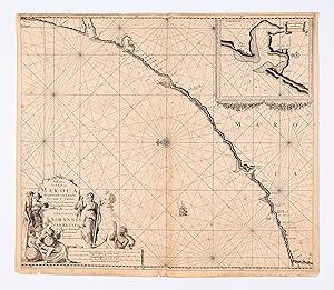
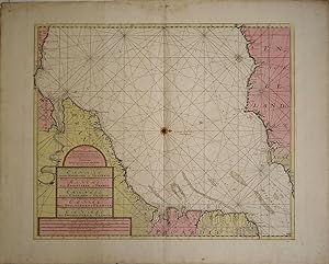
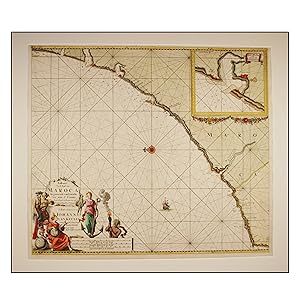
Paskaart Van de Kust van Maroca Beginnende van Larache tot aan C. Cantin Met syn Diepte en Droogte dus ver Naaukerig Opgestelt en Verbetert.
Publicado por Amsterdam:, 1681
Librería: Robert Frew Ltd. ABA ILAB, London, Reino Unido
Miembro de asociación: ABA ILAB PBFA
Valoración del vendedor:
Mapa
50.5 x 58 cm. Uncoloured. Double page chart of the central coastline of Morocco orientated with north to the left edge. Inset plan of the bay at Sale and Rabat. Chart with rhumb lines, compass roses and an illustration of a ship to the sea. Some spots scattered across image. Some light offsetting, lightly browned overall. Small section reinforced on verso at centrefold.
-
De Baay van Tanger. Te Amsterdam by G. Hulst van Keulen. Zeigt Bucht mit Windrose, nautische Angaben, oben links Legende a-n.
Publicado por Amsterdam, Gerard Hulst van Keulen., 1781
Librería: Antiquariat an der Stiftskirche, Bad Waldsee, Alemania
Valoración del vendedor:
Arte / Grabado / Póster
Kupferstich altkoloriert. 45 x 59 cm (Plattengröße), unter Glas gerahmt, im oberen Bug schwacher Feuchtigkeitsrand, schlichte dekorative Karte, Johannes van Keulen - 1678-1704 tätig in Amsterdam als Kartenverleger, publizierte 'De Groote nieuwe Zee-Atlas' erstmals 1680, dieser wurde in den folgenden Auflagen (ab 1687) auf 5 Bände erweitert.--- In 1678, Johannes registered with the Amsterdam Booksellers Guild as a "bookseller and Cross-staff maker" By this time, most of the Amsterdam chart makers and instrument makers, like Blaeu, Janssonius, Hondius, Goos, and Doncker, had either closed down or were at the end of their fame. As a result, Johannes van Keulen had the opportunity to obtain copperplates, privileges, and stocks of many of his former competitors. Besides manuals and cross-staffs, Johannes produced his famed 'ZeeAtlas' (Sea Atlas, 5 volumes), and 'ZeeFakkel' (Sea pilotbook, 5 volumes).- Gerard Hulst van Keulen, (1733-1801) was the great-grandchild of the founder Johannes.- Sprache: Niederländisch. * * * * --- due to EPR-Restrictions NO SHIPPING to Bulgaria, Danmark, Greece, Luxembourg, Poland, Romania, Sweden, Slovakia and Spain --- * * * *.
-
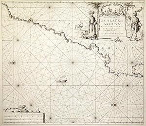
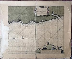
Paskaart van de Kuste van Gualate en Arguyn. Beginnende van C. Bajador to C. Blanco Seer Nau-keurigh op-gestelt.
Publicado por Amsterdam:, 1681
Librería: Robert Frew Ltd. ABA ILAB, London, Reino Unido
Miembro de asociación: ABA ILAB PBFA
Valoración del vendedor:
Mapa
50.1 x 56.9 cm. Uncoloured. Double page chart showing the coastline of what is now Western Sahara orientated with north to the left edge. Ornate title cartouche to upper right corner featuring two costumed figures in Arab dress, in the background a horseman and a camel. The cartouche also bears a vignette illustration of hunting scene. The chart with rhumb lines, compass roses and an illustration of a dhow to the sea. Neat repair at lower edge of centrefold. Two small brown marks to lower left corner, otherwise in very good condition.
-
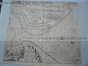
White Sea/Kola, map anno 1715, J. van Keulen
Publicado por Keulen Johannes van 1654-1715, 1715
Librería: Hammelburger Antiquariat, Hammelburg, Alemania
Valoración del vendedor:

Hardcover. Condición: very good. White Sea/Kola, map anno 1715, J. van Keulen Coppermap, edited by J. van Keulen, anno 1715, "Paskaart van de Mont van de WITTE ZEE.", size of the leaf: 53x60 cm., minor cracs on margins, little brownish.
-
Paskaart, voor een Gedeelte der Kust van, Barbaria, van C. Ivi, tot Bona. En de Kust van, Catalonia.Eylanden, Yvica, Majorca, en Minorca
Publicado por Artist: Keulen Johannes van ( - 1715 ) Amsterdam ; issued in: Amsterdam ; ca: 1750; - Johannes van Keulen (1654 - 1715) was a 17th-century Dutch cartographer He published the influential nautical atlas the Zee-Atlas and the pilot guide Zee-Fakkel In 1678 Johannes van Keulen established himself in Amsterdam and in 1680 he obtained a patent from the States of Holland and West Friesland allowing him to print and publish maritime atlases and shipping guides These were books of maps and descriptions of itineraries used by helmsmen for safe navigation The patent was a kind of protection against illegal copying of produced books and charts This was especially important for the atlases which were made with extensive initial costs Van Keulen named h, 1654
Librería: Antique Sommer& Sapunaru KG, München, Alemania
Miembro de asociación: ILAB VDA
Valoración del vendedor:
Technic: Copper print; colorit: colored; condition: Upper and lower margin cutted, missing part!, size (in cm): 36 x 58; - Part of the map from van Keulen of the coast of Catalonia, Majorca, Minorca, Ibiza and part of the Barbary coast.; - Special feature: De Nieuwe Groote Lichtende Zee-Fackel.
-
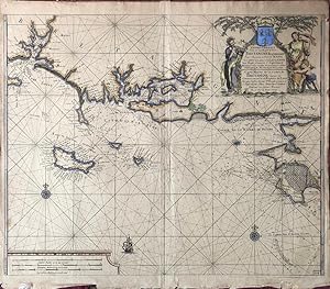
Nieuewe Pascaart Van de Zeekusten Van Bretangne Beginnende Van t' Incoomen Van de Rivier de Loire tot dan t' Eylandt de Groa door Vooght Geometra. (Also titled in French:) Carte Marine de la Costes de Bretangne depuis la Commancement de la Rivierre de Loire Jus'quia Isle de Groa Pr Vooght Geometra.
Publicado por Amsterdam: Van Keulen, [c.1728]., 1728
Librería: William Matthews/The Haunted Bookshop, Sidney, BC, Canada
Miembro de asociación: ABAC ILAB
Valoración del vendedor:
A copper engraved map on laid paper, large colour cartouche at top right containing a coat-of-arms, with text in Dutch and French. Map is hand-coloured. Also a small sailing ship and two compass roses. Imprint in cartouche: "t' Amsterdam by Johannes van Ceulen, Boekverkooper Aand Nieuwenbrugh Met Privilegie Voor 15 Iaar" and in French: "d'Amsterdam Chez Iean Van Ceulen Vendeur des Cartes Marines Vis a' Vis du Pont Neuf". Small number "22&1/2" printed in lower right corner. Plate size is 60cm x 49cm, on a sheet measuring 62cm x 54cm. Verso blank. An attractive map with a handsomely coloured cartouche. From Van Keulen's "De Nieuwe Groote Ligtende Zee-Fakkel." [1728 - many editions]. The cartouche attributes the map to Claes Jansz Vooght; the art in the cartouche may be by Jan Luyken, as he illustrated Van Keulen's Atlas. A map of the coast of France, Brittany and the coast near the mouth of the Loire River.
-
De Nieuve Groote Ligtende Zee-Fakkel.
Publicado por 1969-1970, 1969
Librería: Berkelouw Rare Books, Berrima, NSW, Australia
Miembro de asociación: ANZAAB ILAB
Valoración del vendedor:
Amsterdam 1716-1753. Reprinted, New York: Da Capo Press & Amsterdam: Theatrum Orbis Terrarum, (1969-1970). 6 parts in 3 vols. Elephant folio. Orig. cloth. Gilt. Spines uniformly gilt with raised bands and morocco titling-labels (slightly rubbed). With illusts., fold. map & charts some of which are coloured. Peel marks on end-papers. Complete and as new, albeit ex-library with stamps on edge of text-block. Lim. ed. of 500 numbered sets.
-
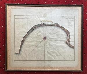
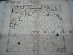
Nieuwe en seer nette Caart van de Baay en Stadt GIBRALTAR. Geteckent door den Wel Ed. Hr. H. Leynslager Cap. in't Edel Moogende Collegie ter Admiraliteyt alhier. -- Niederländische Seekarte der Bucht von Gibraltar - westorientiert - mit Windrose, nautischen Linien, Sandbänken mit Tiefenangaben. 2 Kartuschen sowie Legende A-L und Meilenzeiger deutsch und französisch. Gibraltar, die Küstenlinie sowie einige markante Punkte mehrfarbig koloriert.
Publicado por Amsterdam, Johannes van Keulen, []., 1695
Librería: Antiquariat an der Stiftskirche, Bad Waldsee, Alemania
Valoración del vendedor:
Arte / Grabado / Póster
Kupferstich altkoloriert. 54 x 63 cm (Blattgröße), unter Glas gerahmt, leichte Mittelfalte etwas knittrig, kleinere Randläsuren, Rahmen etwas bestossen, Verlagskartusche: 'Tot Amsterdam by Joannes van Keulen Beekverkooper aan de Nieuwebrug inde Gekroonde Lootsman'.-- Johannes van Keulen - 1678-1704 tätig Kartenverleger in Amsterdam, publizierte 'De Groote nieuwe Zee-Atlas' erstmals 1680 und wurde in den folgenden Auflagen auf 5 Bände (von 1687 ab) erweitert.-- In 1678, Johannes registered with the Amsterdam Booksellers Guild as a "bookseller and Cross-staff maker" By this time, most of the Amsterdam chart makers and instrument makers, like Blaeu, Janssonius, Hondius, Goos, and Doncker, had either closed down or were at the end of their fame. As a result, Johannes van Keulen had the opportunity to obtain copperplates, privileges, and stocks of many of his former competitors. Besides manuals and cross-staffs, Johannes produced his famed 'ZeeAtlas' (Sea Atlas, 5 volumes), and 'ZeeFakkel' (Sea pilotbook, 5 volumes).- Sprache: Niederländisch. * * * * --- due to EPR-Restrictions NO SHIPPING to Bulgaria, Danmark, Greece, Luxembourg, Poland, Romania, Sweden, Slovakia and Spain --- * * * *.
-
Scotland/Westcoast, anno 1712, J. van Keulen map, coloured
Publicado por Keulen Johannes van 1654-1715, 1712
Librería: Hammelburger Antiquariat, Hammelburg, Alemania
Valoración del vendedor:
Mapa
Kein Einband. Condición: Befriedigend. Copperengraving, edited by J. van Keulen "Pascaert vande westkust van SCHOTLANT, als mede een gedeelte van de Lewys Eylanden, van S. Patricius.", coloured, size: 505x564 mm., some minor cracs on margins, Amsterdam, anno 1712.
-
PASKAART VAN DE KUST VAN MAROCA BEGINNENDE VAN LARACHE TOT AAN C. CANTIN MET SYN DIEPTE EN DROOGTE DUS VER NAAUKERIG OPGESTELT EN VERBETERT
Publicado por Van Keulen, 1690
Librería: LIBRERIA ANTICUARIA MARGARITA DE DIOS, MADRID, Espańa
Miembro de asociación: LANCE
Valoración del vendedor:
Mapa
Sin Encuadernar. Condición: Bien. Materia: Carta náutica de la segunda mitad del siglo XVII. Marruecos. Larache - Johannes Van Keulen. Publicación: Ámsterdam, Van Keulen, c. 1690. Técnica: Grabado calcográfico. Precioso coloreado de época. Descripción: Carta náutica de la costa central de Marruecos con un plano insertado en el margen superior izquierdo de la bahía de Rabat, un barco surcando los mares, una rosa de los vientos y gran cartela con título y longitudes. Medidas: 510 x 585 mm [huella], 540 x 610 mm [papel], 715 x 795 mm [passepartout]. Conservación: Buen estado. Reforzado en la trasera con papel. Biografía del autor: Johannes van Keulen (1654, Deventer - 1715, Ámsterdam) fue un cartógrafo holandés del siglo XVII. Publicó el influyente atlas náutico Zee-Atlas y la guía piloto Zee-Fakkel (que significa antorcha marina es castellano). En 1678 Johannes van Keulen se estableció en Ámsterdam y en 1680 obtuvo una patente de los Estados de Holanda y Frisia Occidental que le permitía imprimir y publicar atlas marítimos y guías de navegación. Eran libros de mapas y descripciones de itinerarios, utilizados por los timoneles para una navegación segura. La patente era una especie de protección contra la copia ilegal de libros y gráficos producidos. A partir de 1681 apareció el Nieuwe Lichtende Zee-Fakkel, un atlas de cinco volúmenes, publicado entre 1681-1684, que contenía más de 130 cartas nuevas y que le hizo famoso. RBS1 Este artículo necesita permiso de exportación / This item needs an export permit.
-
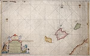
Linee di costa: isole Baleari, Spagna.
Publicado por Francia,, 1735
Librería: libreria antiquaria perini Sas di Perini, Verona, VR, Italia
Miembro de asociación: ALAI ILAB
Valoración del vendedor:
Arte / Grabado / Póster
Incisione in rame, 410x540. Raffigura le coste di Maiorca, Ibiza, Formentera e Catalogna. Ben conservato, carta ingiallita.
-
De nieuwe groote ligtende zee-fakkel: Amsterdam 1716-1753 (2 volumes)
Publicado por Amsterdam : Theatrum Orbis Terrarum, 1969
Libro
Condición: Good. 2 (of 3) uniform gilt lettered brown leatherette volumes, (foldanle) maps in b/w, large folio. Limited edition of 500 numbered copies, however, this is an unnumbered copy.; Edges covers lsightly worn.
-
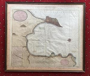
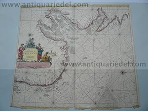
Pas-Kaart, Van de Zee-Kusten, van, Brazilia, Tusschen, Punto de Lucena en Cabo S. Augustino. Door Vooght, Geometra.
Publicado por Amsterdam: Van Keulen, [c.1728]., 1728
Librería: William Matthews/The Haunted Bookshop, Sidney, BC, Canada
Miembro de asociación: ABAC ILAB
Valoración del vendedor:
A copper engraved map on laid paper, large colour cartouches at top and bottom, map hand-coloured. Also a small sailing ship and two compass roses (North is indicated to the right of the map). Imprint in lower cartouche: 't Amsterdam, By, Iohannis Van Keulen, Boek en Zee-Kaart verkooper, aan de Niewe-brugh. Small number "13" printed in lower right corner. Plate size is 60cm x 51cm, on a sheet measuring 75cm x 61cm. Verso blank. Old stain to left side extending slightly into plate, yellow remains of old tape repairs to fold on verso, splitting along fold, tears to margins, otherwise generally very good. An attractive map with handsomely coloured cartouches. From Van Keulen's "De Nieuwe Groote Ligtende Zee-Fakkel." [1728 - many editions]. The map is by Claes Jansz Vooght; cartouche art may be by Jan Luyken, who illustrated Van Keulen's Atlas. A map of the East coast of Brazil. The upper cartouche depicts natives with weapons: a sword & shield and a bow; the lower cartouche depicts a mermaid, a sea god, and mermen, one of whom holds a Jacob's staff.
-
Mer du Nord Europe. England, Hull, anno 1715, Van Keulen map-scarce
Publicado por Keulen Johannes van 1654-1715, 1715
Librería: Hammelburger Antiquariat, Hammelburg, Alemania
Valoración del vendedor:
Mapa
Kein Einband. Condición: Befriedigend. East-England/anno 1715, map, van Keulen Coppermap, edited by J. van Keulen, anno 1715, "Pas-caert Vande Zee-custen van ENGELAND.", old colours, some cracs on margins, more on below margin, size of the leaf: 52x59 cm.
-
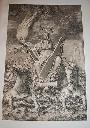
De Nieuwe Groote Lichtende Zee-Fakkel.FRONTISPIECE. Sea Goddess with Sea Torch. From First Edition.
Publicado por Johannes van Keulen, 1681-1684., Amsterdam:, 1681
Librería: Dark Parks Books & Collectibles, Fallon, NV, Estados Unidos de America
Valoración del vendedor:
From first edition. Very rare. Fantastic frontispiece. Trimmed just outside of border. Mounted on larger plain leaf. Privilege text is on verso. Suitable for framing, or perhaps mating with another copy. Dramatic frontispiece from Part IV of Keulen?s Zee-Fakkel, or ?Sea Torch? Illustrates a sea-goddess representing navigation and trade, with an armillary sphere as a head piece, in a shell chariot pulled by two sea-horses. She holds a rudder and a torch signifying the guidance by the atlas of the charts. Artist is Jan Luyken. Johannes van Keulen (1654-1715), Dutch bookseller and cartographer, publisher of the influential nautical works Zee-Atlas and the pilot guide Zee-Fakkel. The Zee-Fakkel was published in 5 volumes between 1681 and 1684, with over 130 new charts/maps by Claes Jansz Vooght and illustrations by Jan Luyken. The work made Keulen famous. Complete copies of the Zee-Fakkel, when on the market, fetch high six figures, monetarily. Citations: Keulen Cartography: 195-204. Amsterdam Museum: A51379.
-
De Groote nieuwe vermeerderede Zee-Atlas ofte Water-Waereld. Frontispiece only. Very rare. Single leaf.
Publicado por [Gerard van Keulen,] [1708]., [Amsterdam:], 1708
Librería: Dark Parks Books & Collectibles, Fallon, NV, Estados Unidos de America
Valoración del vendedor:
Original frontispiece to the van Kuelen masterpiece sea-atlas De Groote Nieuwe Vermeerderede Zee-Atlas ofte Water-Waereld. Vertoonende in zig alle de Zee-kusten des Aardryks. [Amsterdam, 1708]. Leaf has been adhered at corners to another sheet. Trimmed at border line with some minor edge wear and soiling. Beautiful illustration and most suitable for framing. We find only one copy in reference, which was sold at Christie?s UK for over $200,000.00 at auction in May, 2022. The frontispiece is a match at all points, though trimmed and uncolored [the Christie?s copy full and in color]. ?The most complete sea-atlas by the Van Keulens, composed of nearly all the charts published up to the date 1709? [-Koeman].?The firm of van Keulen, active continuously from 1678 to 1885, was the largest private hydrographic chart-publishing agency in the world. Three generations of the family were active during the period when Amsterdam was at its height as a mercantile and shipping power. As a by-product of this, Amsterdam became the leading European centre of marine cartography, densely populated with the best chart-makers and publishers. Pre-eminent among these firms were the van Keulens who produced ?the largest and finest marine atlases in Holland? (Koeman). ?Johannes van Keulen (1654-1711) was the founder of the firm, enrolling in the booksellers? guild in Amsterdam in 1678. In 1680 he published the first part of his Zee-Atlas, by which the reputation of the firm was established. Although the family business was closely tied to maritime publications, Johannes himself was not a chart-maker, but simply an interested publisher. He was fortunate that, from the outset, he employed the skilled surveyor Claes Janszoon Vooght, who actually prepared the charts and also wrote the text. Over the years the Zee-Atlas was expanded to five parts, and it continued in print, in one form or another, until 1734. More ambitious, and with a far longer and more complicated history, was his pilot book, the Zee-Fakkel, which was first published in 1681-82, and continued in print to about 1800. The family also published books on every aspect of geography, navigation and nautical matters. Johannes?s son Gerard (c. 1678-1727) gradually succeeded him from about 1704. In contrast to his father, Gerard was a talented engraver, mathematician, and chart-maker, whose abilities were recognised when he was appointed Hydrographer to the Dutch East India Company in 1714. Under his guidance, the Zee-Atlas and Zee-Fakkel were greatly revised and improved, and many new charts introduced. After Gerard?s relatively early death in 1727, he was succeeded by his widow and later by his son Johannes II who is known in particular for publishing the sixth volume of the Zee-Fakkel ? this volume contained the previously secret cartography of the East India Archipelago.? [Christie?s lot 8, May 24, 2022].
-
Nordfriesland/Jütland, anno 1715, Van Keulen, Karte "Paskaart vande West Kust van Jutland Van Busem tot aent Jutsche Riff." Seekarte veröffentlicht bei Van Keulen, anno 1715, mit der Westküste von Schleswig-Holstein und Dänemark mit den Nordfriesischen Inseln. Blattmaß: 53x60 cm., guter Erhaltungszustand.
Ańo de publicación: 1715
Librería: Hammelburger Antiquariat, Hammelburg, Alemania
Valoración del vendedor:
Mapa
Kein Einband. Condición: Befriedigend. Nordfriesland/Jütland, anno 1715, Van Keulen, Karte "Paskaart vande West Kust van Jutland Van Busem tot aent Jutsche Riff." Seekarte veröffentlicht bei Van Keulen, anno 1715, mit der Westküste von Schleswig-Holstein und Dänemark mit den Nordfriesischen Inseln. Blattmaß: 53x60 cm., guter Erhaltungszustand.
-
Jutland/North Frisian Islands, anno 1715, Van Keulen, map
Publicado por Keulen Johannes van 1654-1715, 1715
Librería: Hammelburger Antiquariat, Hammelburg, Alemania
Valoración del vendedor:
Hardcover. Condición: very good. "Paskaart vande West Kust van Jutland Van Busem tot aent Jutsche Riff." Seekarte veröffentlicht bei Van Keulen, anno 1715, mit der Westküste von Schleswig-Holstein und Dänemark mit den Nordfriesischen Inseln. Blattmaß: 53x60 cm., guter Erhaltungszustand.
-
Channel/Dover/Calais, anno 1715 J.van Keulen map
Publicado por Keulen Johannes van 1654-1715, 1715
Librería: Hammelburger Antiquariat, Hammelburg, Alemania
Valoración del vendedor:
Hardcover. Condición: very good. Channel/Dover/Calais, anno 1715 J.van Keulen map Channel/Dover/Calais, anno 1715 J.van Keulen map Coppermap, edited by J. van Keulen, anno 1715, printed on thick paper, good image, wide margins, size of the leaf: 62x74 cm.
-

Cust van Hispangien"
Publicado por Artist: Keulen Johannes van ( - 1715 ) Amsterdam ; issued in: Amsterdam ; ca: 1680; - Johannes van Keulen (1654 - 1715) was a 17th-century Dutch cartographer He published the influential nautical atlas the Zee-Atlas and the pilot guide Zee-Fakkel In 1678 Johannes van Keulen established himself in Amsterdam and in 1680 he obtained a patent from the States of Holland and West Friesland allowing him to print and publish maritime atlases and shipping guides These were books of maps and descriptions of itineraries used by helmsmen for safe navigation The patent was a kind of protection against illegal copying of produced books and charts This was especially important for the atlases which were made with extensive initial costs Van Keulen named h, 1654
Librería: Antique Sommer& Sapunaru KG, München, Alemania
Miembro de asociación: ILAB VDA
Valoración del vendedor:
Mapa
Technic: Copper print; colorit: colored; condition: Very good, size (in cm): 39 x 52; - chart of the Strait of Gibraltar.
-
Galconda Orixa Bengal
Publicado por Artist: Keulen Johannes van ( - 1715 ) Amsterdam ; issued in: Amsterdam ; ca: 1690; - Johannes van Keulen (1654 - 1715) was a 17th-century Dutch cartographer He published the influential nautical atlas the Zee-Atlas and the pilot guide Zee-Fakkel In 1678 Johannes van Keulen established himself in Amsterdam and in 1680 he obtained a patent from the States of Holland and West Friesland allowing him to print and publish maritime atlases and shipping guides These were books of maps and descriptions of itineraries used by helmsmen for safe navigation The patent was a kind of protection against illegal copying of produced books and charts This was especially important for the atlases which were made with extensive initial costs Van Keulen named h, 1654
Librería: Antique Sommer& Sapunaru KG, München, Alemania
Miembro de asociación: ILAB VDA
Valoración del vendedor:
Technic: Copper print; colorit: original colored; condition: Tear on upper margin perfectly restored, size (in cm): 44,5 x 56; - Map depicts the south eastern coast of India with the source of the river Ganges.
-
Sussex/South England, map, van Keulen anno 1715
Publicado por Keulen Johannes van 1654-1715, 1715
Librería: Hammelburger Antiquariat, Hammelburg, Alemania
Valoración del vendedor:
Hardcover. Condición: very good. Coppermap, edited by J. van Keulen, approx. anno 1715, published in Amsterdam, printed on thick paper, no cracs, very good condition. Size of the leaf: 61x74 cm.
-
Cornwall, map anno 1715, van Keulen
Publicado por Keulen Johannes van 1654-1715, 1715
Librería: Hammelburger Antiquariat, Hammelburg, Alemania
Valoración del vendedor:
Arte / Grabado / Póster
Hardcover. Condición: Gut. Cornwall, map anno 1715, van Keulen Coppermap, edited anno 1715, by van Keulen, size of the leaf: 61x74 cm., some restorations on margins, little brownish.
-
Cape Verde, anno 1715, map van Keulen
Publicado por Keulen Johannes van 1654-1715, 1715
Librería: Hammelburger Antiquariat, Hammelburg, Alemania
Valoración del vendedor:
Hardcover. Condición: very good. Coppermap, edited by J. van Keulen, anno 1715, good print, printed on thick paper, small brown crac in the map (1x1mm, easy to restore),Coppermap, edited by J. van Keulen, anno 1715, "Pas-caert Vande Zee-custen van ENGELAND.", old colours, some cracs on margins, more on below margin, size of the leaf: 52x59 cm. size of the leaf: 54x60 cm.