
Importe total (1 artĒculo artĒculos):
Destino del pedido:

JANVIER, SR (6 resultados)
Ir a los resultados principales
Tipo de artĒculo
- Todo tipo de artĒculos
- Libros (4)
- Revistas y publicaciones
- C¾mics
- Partituras
- Arte, grabados y p¾sters
- FotografĒas
- Mapas (2)
-
Manuscritos y
coleccionismo de papel
Condici¾n
Encuadernaci¾n
- Todo
- Tapa dura
- Tapa blanda (2)
Mßs atributos
- Primera edici¾n (1)
- Firmado
- Sobrecubierta
- Con imßgenes del vendedor (4)
- Sin impresi¾n bajo demanda
Ubicaci¾n del vendedor
Valoraci¾n de los vendedores
-

The Road to Spiritual Success: A Journey To Becoming!
Publicado por Deion Pierre, 2021
ISBN 10: 0578786826ISBN 13: 9780578786827
Librería: SecondSale, Montgomery, IL, Estados Unidos de America
Valoraci¾n del vendedor:

Libro
Condici¾n: Good. Item in good condition. Textbooks may not include supplemental items i.e. CDs, access codes etc.
-
The Road to Spiritual Success: A Journey To Becoming!
Publicado por Deion Pierre, 2021
ISBN 10: 0578786826ISBN 13: 9780578786827
Librería: GoldenWavesOfBooks, Fayetteville, TX, Estados Unidos de America
Valoraci¾n del vendedor:
Libro
Paperback. Condici¾n: new. New. Fast Shipping and good customer service.
-
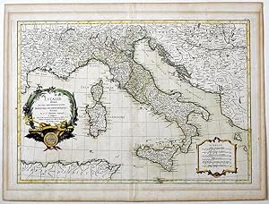
L'ITALIE divis├ e en ses differents etats, ROYAUMES ET REPUBLIQUES
Publicado por JEAN LATTRE (1743 - 1793), PARIS, 1762
Librería: Stampe Antiche e Libri d'Arte BOTTIGELLA, VIGEVANO, PV, Italia
Valoraci¾n del vendedor:
Carta geografica acquerellata con dim. L. 49,2 X 37,2 cm. l'intero foglio compreso i margini (L. 44 x 30,8 cm. la sola parte incisa) - All'interno del cartiglio al centro a sx.: L'ITALIE divis├ e es ses differents etats ROYAUMES ET REPUBLIQUES dress├ e Par le S.r JANVIER Geographe / A PARIS / Chez Lattr├ Graveur rue St. Jacques au dessus de la Fontaine St. Severin a la Ville de Bordeaux / Avec Priuilege du Roy. in basso a dx entro cartiglio semplice: ECHELLE / Milles communs d'Italie / Milles communs de Piemont / Milles Romains et de Milan / Milles de Venise / Lieues Marines ou Grandes Lieues de la France / Lieues Communes de France. - In buone condizioni. Carta appartenente all'opera: ATLAS MODERNE ou Collection de Cartes sur Tous les Parties du Globe Terrestre Par Plusieurs Auteurs, Paris 1762 e derivante dalla carta del D'Anviulle del 1743.
-
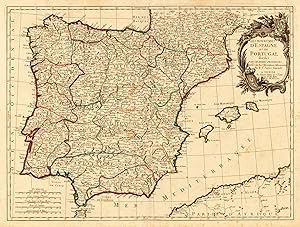
Les Royaumes d'Espagne et de Portugal, divisķs par grandes provinces. Dressķs sur les Observat. Astron.
Librería: LibrerĒa Anticuaria Antonio Mateos, Malaga, Espa±a
Miembro de asociaci¾n: AILA ILAB
Valoraci¾n del vendedor:
Paris, chez Lattrķ, (1762), mapa de 30,5 x 44 cm., grabado en cobre con los contornos y la cartela coloreados a mano.
-
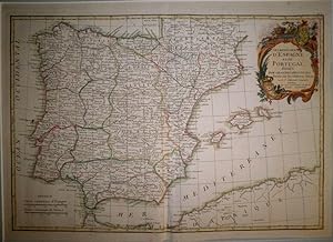
Les Royaumes d`Espagne et de Portugal divisķs par grandes provinces. Dressķs sur les Observations Astronomiq. Par le Sr. Janvier Geographe A Venise Par Francois Santini rue Ste. Justine pres la dite Eglise Chez M. Remondini.
Publicado por Santini/Remondini, Venice, 1778
Librería: Antiquariat Reinhold Berg eK Inh. R.Berg, Regensburg, Alemania
Miembro de asociaci¾n: ILAB VDA
Valoraci¾n del vendedor:

Mapa
Other. Copper engraving, hand colored in outline when published. A large and decorative map of Spain and Portugal divided up into its individual provinces. In the upper right corner we find the allegoric title cartouche with two coast of arms. At the lower left corner we see the mileage scale. The Balearic Islands Majorca, Menorca and Formentera are also engraved. The map is very detailed engraved with many place names, rivers, mountains,etc. In very good condition. One small carefully mended tear near the lower centre fold affecting slightly the engraved image of the map. 465 by 627mm (18╝ by 24Š inches). 465 by 627mm (18╝ by 24Š inches).
-
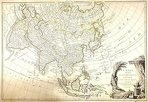
L'ASIE divisķe en ses principaux ETATS par le Sr. Janvier, Geographe A PARIS (Small Size)
A±o de publicaci¾n: 1760
Librería: Tmecca Inc., Seoul, Republica de Corea
Miembro de asociaci¾n: ILAB
Valoraci¾n del vendedor:
Mapa Original o primera edici¾n
No Binding. Condici¾n: As New. 1st Edition. 47 x 32cm This is a beautiful example of Jean Janvier's 1760 map of Asia. It covers from Africa and the Mediterranean east to Bering Strait and south as far as Java and New Guinea. This map is most interesting in its rendering of the largely unexplored extreme northwest of Asia. Yeco or Hokkaido is mapped only speculatively with its western borders unknown. Shows Sakhalin Island in an embryonic state.