
Importe total (1 artículo artículos):
Destino del pedido:

JAN JANSSON 1588 1664 (13 resultados)
Ir a los resultados principales
Tipo de artículo
- Todo tipo de artículos
- Libros (5)
- Revistas y publicaciones
- Cómics
- Partituras
- Arte, grabados y pósters (1)
- Fotografías
- Mapas (7)
-
Manuscritos y
coleccionismo de papel
Condición
- Todo
- Nuevos
- Antiguos o usados
Encuadernación
- Todo
- Tapa dura (1)
- Tapa blanda
Más atributos
- Primera edición
- Firmado
- Sobrecubierta
- Con imágenes del vendedor (12)
- Sin impresión bajo demanda
Ubicación del vendedor
Valoración de los vendedores
-
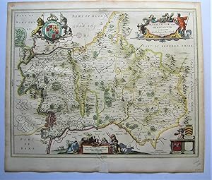
AN ORIGINAL ENGRAVED MAP OF Herefordshire. Herefordia Comitatus vernacule Hereford Shire
Publicado por Atlas Novus Ca 1690, 1690
Librería: PROCTOR / THE ANTIQUE MAP & BOOKSHOP, DORCHESTER, Reino Unido
Miembro de asociación: PBFA
Valoración del vendedor:

Mapa
Lg.map (engr.surface 20.5 x 15.5 inches). In ivory mount. Black & Gilt glazed frame. Framed Size 28 x 23 inches An attractive and decorative map in very good condition. Nicely Original hand-coloured. he map has a decorative cartouche, illustrations of various coats of arms and cherubs in the top right corner and cherubs and a man making use of the measurement legend in the bottom left corner. Jan Jansson Jr (1588-1664), or Johannes Janssonius, was the son of a bookseller and publisher who had worked with Jodocus Hondius Sr. From about 1633 onwards, his imprint appears on the title-pages of the Mercator-Hondius "Atlas", in conjunction with his brother-in-law, Henry, as they re-issued their "Atlas" in competition with the Blaeus.
-
Fezzae et Marocchi,
Librería: Sephora di Elena Serru, Foligno, Italia
Miembro de asociación: IOBA
Valoración del vendedor:
TiTOLO: "Fezzae et Marocchi" tratto dal Nieuwen Atlas Amstelodami, Sumptibus Joannis Janssonii 1650 circa Dimensioni del foglio: 487 x 595 mm. Dimensioni dell'incisione: 390 x 505 mm. Tecnica: incisione su rame Condizioni generali: Eccellenti rare fioriture. Meravigliosa mappa del Marocco di grandi dimensioni acquarellata a mano tratta dall'Atlante "Nieuwen Atlas" [translation: The New Atlas], di Jan Jansson, pubblicata ad Amsterdam nel 1650 circa. La mappa mostra anche lo Stretto di Gibilterra. Titolo decorato con elaborato cartiglio. Descrizione completa del Marocco in lingua latina al verso. Jan Jansson, celebre cartografo, appartenente ad una lunga stirpe di stampatori attivi a partire dal XVII secolo. Si stabilirono prima ad Arnhem poi ad Amsterdam. Furono stampatori di mappe, di libri e librai. Title: "Fezzae et Marocchi" from Nieuwen Atlas Amstelodami, Sumptibus Joannis Janssonii 1650 circa Sheet size: 19.17 x 23.42 in; 487 x 595 mm. Plate area: 15.35 x 19.88 in; 390 x 505 mm. Technique: Copper engraving Overall condition: Excellent condition, with light foxing. A wonderful large scale hand-colored map of Morocco, from one of the great early 17th-century Atlas "Nieuwen Atlas" [translation: The New Atlas], by Jan Jansson, published in Amsterdam in 1650 circa The map shows also the Strait of Gibraltar. Elaborately decorated title and decoration cartouches. Complete description of Morocco in latin language in the verso. Jan Jansson was part of an influential family of map publishers from the Netherland throughout the 17th century and beyond. They were based in Arnhem than in Amsterdam. They were printers, publishers and booksellers. Overall Condition: Excellent.
-
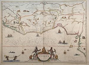
Guinea,
Librería: Sephora di Elena Serru, Foligno, Italia
Miembro de asociación: IOBA
Valoración del vendedor:
TiTOLO: "Guinea" tratto dal Nieuwen Atlas Amstelodami, Sumptibus Joannis Janssonii 1650 circa Dimensioni del foglio: 488 x 595 mm. Dimensioni dell'incisione: 386 x 506 mm. Tecnica: incisione su rame Condizioni generali: Eccellenti rare fioriture. Meravigliosa mappa della Guinea di grandi dimensioni acquarellata a mano tratta dall'Atlante "Nieuwen Atlas" [translation: The New Atlas], di Jan Jansson, pubblicata ad Amsterdam nel 1650 circa. La mappa mostra l'odierna Guinea, Sierra Leone, Liberia, Costa D'Avorio, Ghana, Burkina Faso, Togo, Benin, Nigeria e Camerun. Orientata a 90 gradi a sinistra cosi che la Guinea č in orizzontale. Titolo decorato con elaborato cartiglio e illustrazioni di flora e fauna secondo l'interpretazione europea. Descrizione completa della Guinea in lingua latina al verso. Jan Jansson, celebre cartografo, appartenente ad una lunga stirpe di stampatori attivi a partire dal XVII secolo. Si stabilirono prima ad Arnhem poi ad Amsterdam. Furono stampatori di mappe, di libri e librai. Title: "Guinea" from Nieuwen Atlas Amstelodami, Sumptibus Joannis Janssonii 1650 circa Sheet size: 19.21 x 23.42 in; 488 x 595 mm. Plate area: 15.2 x 19.9 in; 386 x 506 mm. Technique: Copper engraving Overall condition: Excellent condition, with light foxing. A wonderful larg scale hand-colored map of Guinea, from one of the great early 17th-century Atlas "Nieuwen Atlas" [translation: The New Atlas], by Jan Jansson, published in Amsterdam in 1650 circa.The map shows what is now Guinea, Sierra Leone, Liberia, Cotre d Ivoire, Ghana, Burkina Faso, Togo, Benin, Nigeria and Cameroon. Oriented 90 degrees to the left so that the Guinea is horizontal. Elaborately decorated title and decoration cartouches and illustrations of European interpretations of african flora and fauna. Complete description of Guinea in latin language in the verso. Jan Jansson was part of an influential family of map publishers from the Netherland throughout the 17th century and beyond. They were based in Arnhem than in Amsterdam. They were printers, publishers and booksellers. Overall Condition: Excellent.
-
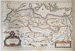
Nova Barbariae descriptio,
Ańo de publicación: 1650
Librería: Sephora di Elena Serru, Foligno, Italia
Miembro de asociación: IOBA
Valoración del vendedor:
TiTOLO: "Nova Barbariae descriptio" from Nieuwen Atlas Amstelodami, Sumptibus Joannis Janssonii 1650 circa Dimensioni del foglio: 485 x 600 mm. Dimensioni dell'incisione: 355 x 525 mm. Tecnica: incisione su rame Condizioni generali: Eccellenti rare fioriture. Meravigliosa mappa del Nord Africa di grandi dimensioni acquarellata a mano tratta dall'Atlante "Nieuwen Atlas" [translation: The New Atlas], di Jan Jansson, pubblicata ad Amsterdam nel 1650 circa. La mappa mostra anche l'odierno Marocco, Algeria, Tunisia, Libia, Egitto. Titolo decorato con elaborato cartiglio e illustrazioni dell'interpretazione europea della flora e fauna africana. Descrizione completa dell'Egitto e Nord Africa in lingua latina al verso. Jan Jansson, celebre cartografo, appartenente ad una lunga stirpe di stampatori attivi a partire dal XVII secolo. Si stabilirono prima ad Arnhem poi ad Amsterdam. Furono stampatori di mappe, di libri e librai. Title: "Nova Barbariae descriptio" from Nieuwen Atlas Amstelodami, Sumptibus Joannis Janssonii 1650 circa Sheet size: 19.09 x 23.62 in; 485 x 600 mm. Plate area: 13.98 x 20.67 in; 355 x 525 mm. Technique: Copper engraving Overall condition: Excellent condition, with light foxing. A wonderful large scale hand-colored map of North Africa, from one of the great early 17th-century Atlas "Nieuwen Atlas" [translation: The New Atlas], by Jan Jansson, published in Amsterdam in 1650 circa. The map shows what is now Morocco, Algeria, Tunisia, Libya, Egypt. Elaborately decorated title and illustrations of European interpretations of african flora and fauna. Complete description of Egypt and North Africa in latin language in the verso. Jan Jansson was part of an influential family of map publishers from the Netherland throughout the 17th century and beyond. They were based in Arnhem than in Amsterdam. They were printers, publishers and booksellers. Overall Condition: Excellent.
-
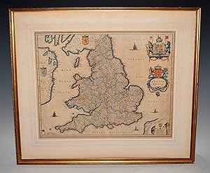
AN ORIGINAL ENGRAVED MAP OF Anglia regnum. Copper engraved map of the Kingdom of England
Publicado por Atlas Novus Ca 1642, 1642
Librería: PROCTOR / THE ANTIQUE MAP & BOOKSHOP, DORCHESTER, Reino Unido
Miembro de asociación: PBFA
Valoración del vendedor:
Mapa
Lg.map (engr.surface 20.5 x 16 inches). In ivory mount. An attractive and decorative map in very good condition. Mount a little tanned. Nicely Original hand-coloured. Jan Jansson Jr (1588-1664), or Johannes Janssonius, was the son of a bookseller and publisher who had worked with Jodocus Hondius Sr. From about 1633 onwards, his imprint appears on the title-pages of the Mercator-Hondius "Atlas", in conjunction with his brother-in-law, Henry, as they re-issued their "Atlas" in competition with the Blaeus.
-
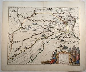
Aegypti recentior descriptio,
Librería: Sephora di Elena Serru, Foligno, Italia
Miembro de asociación: IOBA
Valoración del vendedor:
TiTOLO: "Aegypti recentior descriptio" tratto dal Nieuwen Atlas Amstelodami, Sumptibus Joannis Janssonii 1650 circa Dimensioni del foglio: 487 x 592 mm. Dimensioni dell'incisione: 452 x 506 mm. Tecnica: incisione su rame Condizioni generali: Eccellenti rare fioriture. Piccoli strappi marginaliMeravigliosa mappa dell'Egitto di grandi dimensioni acquarellata a mano tratta dall'Atlante "Nieuwen Atlas" [translation: The New Atlas], di Jan Jansson, pubblicata ad Amsterdam nel 1650 circa. La mappa mostra il Cairo e il fiume Nilo cosi come sfocia al Mar Mediterraneo. Orientata a 90 gradi a sinistra cosi che l'Egitto č in orizzontale. Bellissima raffigurazione delle Piramidi. Descrizione completa dell'Egitto in lingua latina al verso. Jan Jansson, celebre cartografo, appartenente ad una lunga stirpe di stampatori attivi a partire dal XVII secolo. Si stabilirono prima ad Arnhem poi ad Amsterdam. Furono stampatori di mappe, di libri e librai. Title: "Aegypti recentior descriptio" from Nieuwen Atlas Amstelodami, Sumptibus Joannis Janssonii 1650 circa Sheet size: 19.7 x 23.3 in; 487 x 592 mm. Plate area: 17.8 x 19.9 in; 452 x 506 mm. Overall condition: Excellent condition, with light foxing. Very little tears in the edges. A wonderful large scale hand-colored map of Egypt, from one of the great early 17th-century Atlas "Nieuwen Atlas" [translation: The New Atlas], by Jan Jansson, published in Amsterdam in 1650 circa. The map shows Cairo and the Nile River as it flows from the Mediterranean Sea. Oriented 90 degrees to the right so that the Nile is horizontal. Wonderful depiction of the Pyramids. Complete description of Egypt in latin language in the verso. Jan Jansson was part of an influential family of map publishers from the Netherland throughout the 17th century and beyond. They were based in Arnhem than in Amsterdam. They were printers, publishers and booksellers. Overall Condition: Excellent.
-
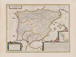
Hispaniae Veteris Descriptio.
Publicado por Amsterdam, Janssonius, [c.]., 1662
Librería: Inanna Rare Books Ltd., Skibbereen, CORK, Irlanda
Valoración del vendedor:
Arte / Grabado / Póster
Original hand-coloured copper engraving. Plate Size: 49.2 cm x 37 cm. Sheet Size: 59.8 cm x 45 cm. Original map. Very good condition. Faint hint of foxing along left fore edge. Centre fold as issued. Latin text on reverse. [Koeman I, 6000H:1.2]. Border with longitudinal and latitudinal information. A richly detailed and very interesting map showing Roman Hispania - the Iberian Peninsula and the Balearic Islands. The three Ancient Roman provinces (organised by the emperor Augustus) of Hispania Citerior et Tarraconensis, Hispania Baetica and Lusitania Hispania are shown on the map. Northern tip of Africa ('Hispania Transfretana Sive Tingitana, Qua et Mauritania') pictured also. Relief shown pictorially with rivers, mountains and significant towns and cities depicted. Large decorative cartouche with finely detailed Classical allusions in lower right section of map contains an inset box showing the coastal area around 'Gades' (Cadiz). Cartouche also lists numerous place names of uncertain location (in Latin). Bar-scales within cartouche in top right corner of the map. Decorative title cartouche in lower left corner. Three ships are also pictured suggesting the region's maritime importance. 'Mare Mediterraneum Internum' and 'Ocean Atlanticus, Quod et Mare Hesperium, Vespertinum Occiduum, et Externum' are also listed. Abraham Goos (1590 c. 1643) was a Dutch cartographer, publisher, and engraver. He made globes, maps of North America, a comprehensive map of European coastlines, and the first printed Hebrew language map of The Holy Land. His first teacher was Jodocus Hondius (1563 1612), a renowned map-maker, whose son-in-law was Johannes Janssonius. After Hondius died, his son-in-law Jan Janssonius took over Hondius's business and continued the partnership with Goos. One of Hondius' specialties was the manufacture of globes, and Goos and Janssonius continued this, regularly modifying them as more geographical information became available. In 1616 he published Nieuw Nederlandtsch Caertboeck, an atlas of the Seventeen Provinces in 23 maps, and one of the first atlases of the Netherlands; Johannes Janssonius (1588-1664) was a renowned geographer and publisher of the seventeenth century, when the Dutch dominated map publishing in Europe.
-
Middelsexiae cum Hertfordiae comitatu: Midlesex & Hertford Shire
Publicado por G. Valk & P. Schenk Amsterdam, 1690
Librería: Angelika C. J. Friebe Ltd. - MapWoman, Dorking, Reino Unido
Miembro de asociación: ABA ILAB
Valoración del vendedor:
Mapa
No Binding. Condición: Very Good. copper engraved map with original hand colouring. overall 50 x 58 cm, plate 44 x 54 cm. fold as issued; repair to lower centrefold with old paper on recto; some paper imperfections; hand written annotation in red pencil on recto; o/w vg cond. A very unusual county, showing Middlesex as well as Hertfordhire on one map and the North orientated to the right. With very nice original colour!.
-

Vienna - Austriae. WIEN in Oostenreyk.
Publicado por (1657):, 1657
Librería: Harteveld Rare Books Ltd., Fribourg, Suiza
Miembro de asociación: ILAB VEBUKU
Valoración del vendedor:

39x50 cm (view) 41.5x52 cm (lichtmass) vue ŕ vol d?oiseau, coloriée ŕ la main d?époque, pli au milieu avec légčres traces, / fine handcolored view, light wear on middle fold, sous passepartout dans un cadre or. 56x65 cm (cadre) / framed. Please notify before visiting to see a book. Prices are excl. VAT/TVA (only Switzerland) & postage. Striking early view of Vienna from the east side of the Danube River, published by Jansson in 1657.Includes a key locating 42 points of interest on the map.The map is based upon the view of Vienna which appeared in Braun & Hogenberg'sCivitates Orbis Terrarum.
-
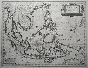
Indiae Orientalis/ Nova Descriptio
Ańo de publicación: 1640
Librería: Angelika C. J. Friebe Ltd. - MapWoman, Dorking, Reino Unido
Miembro de asociación: ABA ILAB
Valoración del vendedor:
Mapa
No Binding. Condición: Very Good. copper engraved map; 39 x 50 cm ; exc. cond. Beautifully decorated map of the East Indies with a nice large cartouche, vignette, scales and 2 windroses. This is one of Jansson s historically most important maps, first published in 1630, being the first map to show evidence of the route taken by the ?Duyfken?, the ship that discovered Australia. The Dutch East India Company had placed a secrecy order on Blaeu, their official cartographer. It is assumed that Jansson either had access to the original map used by the ?Duyfken? or the Hessel Gerritz? map of the Pacific. Beneath New Guinea Duyfkens Eyland is marked. Jansson belonged to the influential map publishing Dutch family, publishing first in Arnhem, then later in Amsterdam. In 1612, he married the daughter of Jodocus Hondius and Colette van den Keere as well as starting up his own business in Amsterdam where he published atlases, maps and globes. In the same year, his father-in-law died and he assisted his widowed mother-in-law with the publication of the Mercator/Hondius atlas. After her and her son?s, Jodocus the Younger, death, Jansson together with his brother-in-law, Henricus Hondius, revised the atlas which, from 1638 onwards, became known as ?Atlas Novus? and was published in several languages over many years. From the early 1640s, Jansson continued on his own to expand the ?Atlas? which then became known as ?Atlas Maior? with editions in Dutch, French, Latin, German ad English.
-
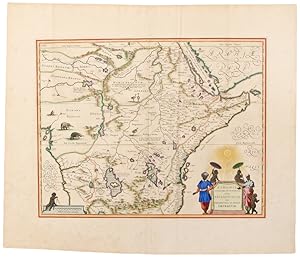
Aethiopia Superior vel Interior vulgo Abissinorum sive Presbiteri Ioannis Imperium
Publicado por Amsterdam, 1640
Librería: Donald A. Heald Rare Books (ABAA), New York, NY, Estados Unidos de America
Miembro de asociación: ABAA ILAB
Valoración del vendedor:
Mapa
Copper engraved double page map, beautifully hand coloured by Dirck Jansz. Van Santen at the time of publication, sheet size: 21 x 24 1/2 inches. Without text on verso. A masterpiece of hand colouring by a Dutch old master. A beautiful map of central and Eastern Africa, including Mozambique north to present day Sudan. The map contains numerous coastal place names such as Mozambique Island, Quiloa, Mombaza, and Melinde indicating the importance of the area to both Arab, Portuguese, and traders and explorers from other countries. The map includes numerous rivers, villages and settlements throughout, and is highly embellished with elephants, ostriches and other animals within the map, as well as a decorative cartouche flanked by natives. The two Ptolemaic lakes of Zaire and Zaflan are in the lower portion of the map; Lake Niger, and the supposed course of the Niger River, is shown flowing westward. This map is based on Ortelius' 1573 map of the fictitious kingdom of Prester John. The myth of Prester John, the good Christian King of Africa waging his own crusade and defeating the enemies of Christianity, was based upon earlier legends of the Crusaders and is a fascinating piece of early mythological cartographic history. The present example is superbly hand coloured by famed illuminator Van Santen, with copious use of gold highlights identifying each town, boundaries, the gradients, the Equator and Tropic of Cancer, the sun burst above the cartouche and other highlights. "Atlases and books coloured by Van Santen figured among the showpieces of the most prominent collections . and [books] decorated by Van Santen were considered gifts worthy of princes . The colours, the gold, the patience and industriousness of Van Santen were obviously of great renown at the end of the 17th century . His use of colour was much freer than that of other colourists. The tone of the colours was made to complement the gold he used so lavishly. In his best work two other costly pigments, ultramarine and carmine are found in large amounts, mostly set against gold" (Goedings). The present map includes the use of ultramarine, i.e. lapis lazuli, on the clothing of the native flanking the left side of the cartouche. Literally meaning "from over the sea," the pigment was made from the semi-precious stone Lapis Lazuli, found at the time only in Afghanistan. During the Rennaissance and Baroque periods, the striking blue pigment, which was more expensive than gold, was used only by artists of great renown, including Vermeer, Titian, Massaccio, and, as the present map confirms, Van Santen. Van der Krogt (Atlantes) 8720:1B; Truusje Goedings, "Dirk Jansz. Van Santen . A Survey" (Amsterdam, 1992).
-
[The World and Continents - Five Maps]
Publicado por Jan Jansson, Amsterdam, 1649
Librería: Donald A. Heald Rare Books (ABAA), New York, NY, Estados Unidos de America
Miembro de asociación: ABAA ILAB
Valoración del vendedor:
Mapa
Copper-engraved maps, from the "Novus Atlas," German text edition, in excellent condition. An excellent set of the World and Continents, by Hondius and Jansson, two of the Netherlands' greatest cartographers. This handsome set of the World and Continents comes from the 1649 German edition of Jan Jansson and Henricus Hondius' Novus Atlas, Das Ist: Welt-Beschreibung mit allerhand schönen newen auszführ lichen Taffeln Inhaltende Die Königreiche und Länder des gantzen Erdtreichs. This monumental work was the inheritor of the legacy of the great atlas first published in 1595 by Rumold Mercator, and later re-issued and revised by Jodocus Hondius and family. In 1630, Willem Blaeu dramatically entered the land atlas market, compelling Jansson and Hondius to mount this powerful reprise. The World map, Nova Totius Terrarum Orbis Geographica ac Hydrographica Tabula, originally dates from 1630, and is present here in the second state, dated '1641', but printed in 1649 using the same plate. It is richly decorated in Baroque style, and is most memorable for the four portraits that adorn it: Julius Caesar and Claudius Ptolemy, at the top; and Gerard Mercator and Jodocus Hondius Sr., at the bottom. Also featured are the four elements of Classical science, illustrated in accordance with Greek and Roman mythology. At the bottom of the composition, between the two hemispheres, are personifications of the four continents. Europe is shown as an enthroned queen with a scepter and a book, symbolising power and knowledge. Alluding to the colonial aspirations of the European powers, Europe accepts gifts offered in outstretched hands by Native Americans, Africans and Asians. In the map, California is shown as an island, a fairly recent innovation, curiously not depicted on the accompanying map of the Americas. The map of Europe, Europa Exactissime Descripta, originally dated 1631, is present here in the second state. Many details regarding the configuration and political boundaries derive from Mercator's map of Europe. The dedication to Louis XIII of France alludes to the alliance forged between France and the United Provinces in 1630, a pact engineered by Cardinal Richelieu which helped guarantee Holland's independence from Spain. (Spain's continued effort to re-invest Holland was one of the ongoing causes of the Thirty Years' War). Africae nova Tabula, first printed in 1631, and present here in the third state, is a fascinating map that reveals the extent to which the interior of the continent largely remained an enigma to Europeans, with the ancient myth that the Nile was fed by two large lakes taking precedence. The coasts, portrayed with relative accuracy, were what really interested the Dutch, who by virtue of their recent seizure of the fortress of Elmina on the Gold Coast had become major protagonists in the African slave trade. The map is embellished with numerous African animals, including ostriches, crocodiles, lions and a griffin. The sea is inhabited by ships, flying fish, sea monsters and the god Neptune. The map of Asia, Asia recens summa cura delineata, was originally printed in 1631, and is present here in the second state, distinguished from the former by the addition of 'Janssonius' as the named publisher. It is dedicated to Eilhard Lubbin, a cartographer and mathematician of Rostock. The image of the Far East is significantly improved from Mercator's example, reflecting information derived from Dutch traders and Jesuit priests. America noviter delineata was first issued by Jodocus Hondius Jr. in 1618, and is present here in the fourth state. Geographically, the map predates the 'California as an Island' phenomenon, and does not include LeMaire's discovery of Cape Horn. The map is elegantly embellished with merchant ships and sea monsters. Burden, The Mapping of North America I, 192; Koeman, Atlantes Neerlandici I (1997 ed.), 1:424/27; Norwich, Maps of Africa, 34; Shirley, The Mapping of the World, 336.
-
![Imagen del vendedor de Atlas Novus, Sive Theatrum Orbis Terrarum: In quo Hispaniae, Italiae, Asiae, Africae, nec-non Americae. Tabulae & Descriptiones luculentissimae. Tomus tertius [dividido en dos partes, cuyas portadas ambas son dos frontis bellamente grabados] a la venta por Librería Miguel Miranda](https://pictures.abebooks.com/inventory/md/md1368321724.jpg)
Atlas Novus, Sive Theatrum Orbis Terrarum: In quo Hispaniae, Italiae, Asiae, Africae, nec-non Americae. Tabulae & Descriptiones luculentissimae. Tomus tertius [dividido en dos partes, cuyas portadas ambas son dos frontis bellamente grabados]
Publicado por Apud Ioannem Ianssonium, 1649
Librería: Librería Miguel Miranda, Lope de Vega n.ş XIX, Madrid, M, Espańa
Miembro de asociación: AILA ILAB
Valoración del vendedor:
Mapa
Condición: Good / Bien. Amstelodami: Apud Ioannem Ianssonium, Anno 1649.- TOMO III, en un volumen de 358 folios, dividido en 2 partes, ambas con sendos frontis grabados al cobre, incluyendo 100 maravillosos mapas a doble folio con los países y continentes citados en la portada, magistralmente grabados al cobre y muy bien conservados; In-Folio Imperial (50 x 35 cm.); Texto en latín; Encuadernado en Plena Piel Pergamino Epoca con dobles ruedas paralelas doradas en planos o tapas, la exterior filete en oro y la interior tipo cadeneta dorada con florones en los ángulos de la rueda interior, y en el centro de ambas gran hierro dorado ornamental barroco floreado. Lomo liso con ruedas paralelas de cadeneta dorada, a modo de nervios, así como florones entre cada rueda.- CONTIENE LOS SIGUIENTES MAPAS, en excelente estado de conservación: HISPANIA: 1. Biscaia y Guipuscoa; 2. León; 3. Galicia; 4. Portugal; 5. Andalucía (Sevilla y Córdoba); 6 Andalucía (Granada y Murcia); 7 Valencia; 8. Aragón; 9. Cataluńa; 10. Baleares insulas. ITALIA: 11. Italia general; 12. Venecia; 13. Bergamo; 14. Brescia; 15. Cremasco; 16 Verona; 17. Polesino di Rovigo; 18. Bizentium; 19 Padova; 20. Trevińano; 21. Belunese; 22. Friuli; 23. Istria; 24. Stato di Milano; 25. Milano pars alpina; 26. Ducato di Milano; 27. Pavia, Lodi; 28. Cremona; 29. Pedemonti; 30. Monferrato e Piemonte; 31. Bercelii; 32. Mantova; 33. Liguria; 34. Genova ponente; 35. Riviera di Genova, levante; 36. Corsica insulae; 37. Sardegna insulae; 38. Lucca; 39. Fiorentino (Dominio) Etruria; 40. Siena con il Ducato di Castro; 41. Parma et Piacenza; 42. Ischia, olim Aenoria; 43. Elba insulae; 44. Ducato di Modena; 45. Vaticano-Dominium Eclesiasticum; 46. Ducato di Ferrara; 47. Romagna e Flaminia; 48. Bologna; 49. Orvieto; 50. Perugino; 51. Urbino; 52. Campagna di Roma et Sabine; 53. Umbría; 54. Dancona, Marchia Anconitana; 55. Nápoles; 56. Abruzzo, citra y ultra; 57. Lavoro; 58. Molise; 59. Citra olim Picentia; 60. Capitanata olim Mesapiae; 61. Bari et Basilicata; 62. Otranto; 63. Calabria citra; 64. Calabria ultra; 65. Sicilia insulae; 66. Candia olim Creta insulae. ASIA: 67. Asia general; 68. Turcicum Imperium; 69. Turquía Natolia; 70. Chipre insulae; 71. Persia; 72. Tartaria sive Magnichami; 73 China; 74. Japón insulae; 75. India oriental; 76. Mongolis Imperium; 77. India oriental insulae; 78. Molucas insulas. AFRICA: 79. Africa general; 80. Barbarie, Tunetonum, Aegiptus; 81. Fez y Marruecos; 82. Guinea; 83. Etiopia Superior Abissiniorum; 84. Etiopía Inferior. AMERICA: 85. América general; 86. Nueva Bélgica y Nueva Inglaterra; 87. Virginia; 88. Virginia y Florida oriental; 89. Bermudas insulas; 90. Nova Hispania et Nova Galicia; 91. Caribe, Insulae Espańola et Cuba; 92. Sud Americae Meridionalis; 93. Nueva Granada et Pompayan; 94. Perú; 95. Venezuela y Nueva Andalucía; 96. Guyana, Amazonam Regio; 97. Brasiliae; 98. Paraguay; 99. Chile; 100. Patagonia, Estrecho de Magallanes. ESTE ATLAS CONSTABA DE 4 TOMOS, PERO ESTE TOMO III QUE OFRECEMOS CONTIENE LOS CODICIADOS MAPAS DE AFRICA, ASIA Y AMERICA, JUNTO CON LOS DE ESPAŃA E ITALIA. MUY RARO. TODOS LOS MAPAS SE ENCUENTRAN EN EXCELENTE ESTADO. La encuadernación, aunque completa, está algo fatigada y con seńales del tiempo, estando el lomo con los dorados poco marcados. Es de lamentar que alguien haya arrancado, y por tanto FALTAN, los tres siguientes mapas: Mapa General de Hispania, Mapa de Navarra Regnum, y Mapa de Castilia Vetus & Nova. Jan Janssonius fue un gran cartógrafo alemán del siglo XVII, siendo además librero y editor, de cuyas prensas salieron maravillosos mapas grabados que rivalizaron en maestría con los de su coetáneo Wilhelm Blaeu y nos ofrecen una impresionante visión geográfica del mundo que se conocía. Libro en latín GEOGRAFÍA, GUÍAS Y ATLAS DEL EXTRANJERO.


![Imagen del vendedor de [The World and Continents - Five Maps] a la venta por Donald A. Heald Rare Books (ABAA)](https://pictures.abebooks.com/inventory/md/md219882674.jpg)