Importe total (1 artículo artículos):
Destino del pedido:

GREENVILLE COLLINS (124 resultados)
Ir a los resultados principales
Tipo de artículo
- Todo tipo de artículos
- Libros (26)
- Revistas y publicaciones
- Cómics
- Partituras
- Arte, grabados y pósters
- Fotografías
- Mapas (97)
-
Manuscritos y
coleccionismo de papel (1)
Condición
Encuadernación
Más atributos
- Primera edición (91)
- Firmado
- Sobrecubierta (1)
- Con imágenes del vendedor (118)
- Sin impresión bajo demanda (118)
Gastos de envío gratis
Ubicación del vendedor
Valoración de los vendedores
-

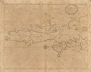
FACSIMILE OF CHART OF EDINBURGH FORTH, 1693
Publicado por Holderness Publications, Burton Pidsea, East Yorkshire, 1980
Librería: K Books Ltd ABA ILAB, York, YORKS, Reino Unido
Miembro de asociación: ABA ILAB PBFA
Valoración del vendedor:

Libro
No Binding. Condición: Very Good. Greenville Collins Ilustrador. Facsimile. Facsimile of the beautifully engraved chart by Collins, with a dedication to the Rt Hon James, Earl of Perth, Lord Chancellor of the Kingdon of Scotland etc from Capt Greenvile Collins, Hydrographer to the King. Printed on thin card. This will be posted rolled, in a tube.
-

Secrets of the trade:For watchmakers and jewelers
Publicado por Hansebooks, 2017
ISBN 10: 3337135390ISBN 13: 9783337135393
Librería: Ria Christie Collections, Uxbridge, Reino Unido
Valoración del vendedor:
Libro Impresión bajo demanda
Condición: New. PRINT ON DEMAND Book; New; Fast Shipping from the UK. No. book.
Más opciones de compra de otros vendedores en IberLibro
Nuevo desde EUR 20,92
-
![Imagen del vendedor de Secrets of the trade. For watchmakers and jewelers . [LeatherBound] a la venta por True World of Books](https://pictures.abebooks.com/inventory/md/md31533781495.jpg)
Secrets of the trade. For watchmakers and jewelers . [LeatherBound]
Ańo de publicación: 2023
Libro Impresión bajo demanda
LeatherBound. Condición: New. LeatherBound edition. Condition: New. Reprinted from 1892 edition. Leather Binding on Spine and Corners with Golden leaf printing on spine. Bound in genuine leather with Satin ribbon page markers and Spine with raised gilt bands. A perfect gift for your loved ones. NO changes have been made to the original text. This is NOT a retyped or an ocr'd reprint. Illustrations, Index, if any, are included in black and white. Each page is checked manually before printing. As this print on demand book is reprinted from a very old book, there could be some missing or flawed pages, but we always try to make the book as complete as possible. Fold-outs, if any, are not part of the book. If the original book was published in multiple volumes then this reprint is of only one volume, not the whole set. Sewing binding for longer life, where the book block is actually sewn (smythe sewn/section sewn) with thread before binding which results in a more durable type of binding. Pages: 100 Language: English.
-
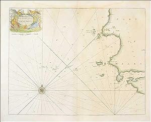
![Imagen del vendedor de [Part of Northumberland] a la venta por Antiqua Print Gallery](https://pictures.abebooks.com/inventory/md/md31458324942.jpg)
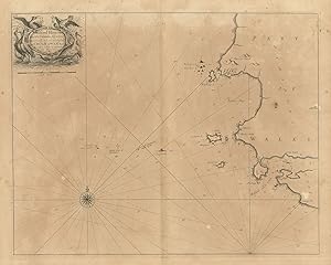
Condición: Good. Coquet Island, Amble & Warksworth. Northumberland coast chart. COLLINS 1693 map. Decorative antique eighteenth century copperplate nautical sea chart, printed on thick paper; Captain Greenvile (or Greenville) Collins. Collins was an officer of the Royal Navy and prominent hydrographer, who was commissioned by King Charles II in 1676 and appointed by Samuel Pepys (then Secretary to the Admiralty), to chart the coasts of Great Britain. The resulting atlas - Great Britain's Coasting Pilot - was the first original sea atlas to be produced by an Englishman. Prior to publication of these maps, nautical charts were often defective, and there was no centralised system for collecting and disseminating the better maps made by experienced seamen. In 1681, Collins gained the king's preferment to survey the country's coasts. The Admiralty supplied Collins with the 8-gun yacht HMSMerlin for the first two years and later the yacht HMSMonmouth until 1686. His work was carried out under the supervision of Trinity House, who also supported the project financially. Samuel Pepys insisted that Collins be made a younger brother of Trinity House. Collins spent seven years on the survey, the first edition of which was published in 1693, as "Great Britain's Coasting Pilot". The charts, while not completely accurate, were an enormous advance on anything before them, entitling Collins to rank as not only one of the earliest, but also among the best of English hydrographers. Twenty-one further editions were published during the eighteenth century. (1693 (First edition)). 18.0 x 24.0cm, 7 x 9.5 inches. Condition: Good. Verso text quite apparent. There is text printed on the reverse side. The map shows part of the Northumberland Coast adjacent to Cocket (Coquet) island, including Hamble (Amble) and Warpsworth (Warksworth).
-
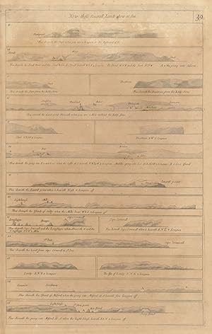
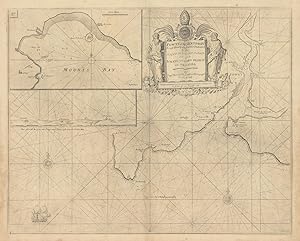
Condición: Good. DEVON CORNWALL & MILFORD HAVEN COAST PROFILES Fowey Scillies. COLLINS 1693 map. Decorative antique eighteenth century copperplate navigational aid, printed on thick paper; Captain Greenvile (or Greenville) Collins. Collins was an officer of the Royal Navy and prominent hydrographer, who was commissioned by King Charles II in 1676 and appointed by Samuel Pepys (then Secretary to the Admiralty), to chart the coasts of Great Britain. The resulting atlas - Great Britain's Coasting Pilot - was the first original sea atlas to be produced by an Englishman. Prior to publication of these maps, nautical charts were often defective, and there was no centralised system for collecting and disseminating the better maps made by experienced seamen. In 1681, Collins gained the king's preferment to survey the country's coasts. The Admiralty supplied Collins with the 8-gun yacht HMSMerlin for the first two years and later the yacht HMSMonmouth until 1686. His work was carried out under the supervision of Trinity House, who also supported the project financially. Samuel Pepys insisted that Collins be made a younger brother of Trinity House. Collins spent seven years on the survey, the first edition of which was published in 1693, as "Great Britain's Coasting Pilot". The charts, while not completely accurate, were an enormous advance on anything before them, entitling Collins to rank as not only one of the earliest, but also among the best of English hydrographers. Twenty-one further editions were published during the eighteenth century. (1693 (First edition)). 45.5 x 28.5cm, 18 x 11.25 inches. Condition: Good. There is nothing printed on the reverse side, which is plain. The sheet depicts coastal recognition profiles for key sections of and features along the coast of south west England (Devon and Cornwall) and Milford Haven (Pembrokeshire), including Start Point (Dartmouth), Prawle Point, Salcombe/Kingsbridge Estuary, Bolt Head, Plymouth, Fowey & Looe, Deadman's (Dodman) Point, The Lizard, Scilly Isles, Cape Cornwall, St Ives, Lundy Island & St Ann's Head/Milford Haven entrance.
-
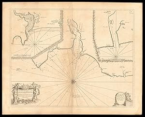
[Part of the Maine Island of Shetland] - To the Rt Honorable Daniel Earle of Nottingham this chart is most humbly dedicated & presented by Capt. Greenvile Collins, Hydroghe. to the King
Ańo de publicación: 1774
Mapa Original o primera edición
Condición: Good. 'Part of the Maine Island of Shetland' sea chart. Lerwick. COLLINS c1774 map. Decorative antique eighteenth century copperplate nautical sea chart, printed on thick paper; Captain Greenvile (or Greenville) Collins. Collins was an officer of the Royal Navy and prominent hydrographer, who was commissioned by King Charles II in 1676 and appointed by Samuel Pepys (then Secretary to the Admiralty), to chart the coasts of Great Britain. The resulting atlas - Great Britain's Coasting Pilot - was the first original sea atlas to be produced by an Englishman. Prior to publication of these maps, nautical charts were often defective, and there was no centralised system for collecting and disseminating the better maps made by experienced seamen. In 1681, Collins gained the king's preferment to survey the country's coasts. The Admiralty supplied Collins with the 8-gun yacht HMSMerlin for the first two years and later the yacht HMSMonmouth until 1686. His work was carried out under the supervision of Trinity House, who also supported the project financially. Samuel Pepys insisted that Collins be made a younger brother of Trinity House. Collins spent seven years on the survey, the first edition of which was published in 1693, as "Great Britain's Coasting Pilot". The charts, while not completely accurate, were an enormous advance on anything before them, entitling Collins to rank as not only one of the earliest, but also among the best of English hydrographers. Twenty-one further editions were published during the eighteenth century. (Published after 1774, possibly in 1792. The atlas within which this map was printed (see provenance) was first published in 1693 with a number of later editions published through the eighteenth century. The publication date stated on the title page of this edition of the atlas is "MDCCLXCII", which is unintelligible and erroneous as it does not conform to standard notation for Roman Numerals. The text within the book from which the map was extracted refers to tidal variations up to the year 1774, hence we state the publication date as after 1774. This edition of the atlas does not appear in the English Short Title Catalogue. The publisher is stated to be "Mount & Davidson", which differs from the publisher of other editions through the early part of the 18th century, which is stated to be "Mount & Page". Mount & Davidson appear to have been active as publishers in the 1780's and early 1790's. A publication date of 1792 (MDCCXCII) would be consistent with stated year of publication if the "L" had been erroneously inserted.). 63.5 x 51.0cm, 25 x 20 inches; this is a folding map. Condition: Good. There are four wormholes which have been professionally restored. Light toning. There is nothing printed on the reverse side, which is plain. The map is orientated toward the west. The island of Bressay, with Lerwick opposite are shown on the left hand side of the chart. The main island runs across the top part of the map.
-
Condición: Good. DEVON CORNWALL & MILFORD HAVEN COAST PROFILES Fowey Scillies. COLLINS 1723 map. Decorative antique eighteenth century copperplate navigational aid, printed on thick paper; Captain Greenvile (or Greenville) Collins. Collins was an officer of the Royal Navy and prominent hydrographer, who was commissioned by King Charles II in 1676 and appointed by Samuel Pepys (then Secretary to the Admiralty), to chart the coasts of Great Britain. The resulting atlas - Great Britain's Coasting Pilot - was the first original sea atlas to be produced by an Englishman. Prior to publication of these maps, nautical charts were often defective, and there was no centralised system for collecting and disseminating the better maps made by experienced seamen. In 1681, Collins gained the king's preferment to survey the country's coasts. The Admiralty supplied Collins with the 8-gun yacht HMSMerlin for the first two years and later the yacht HMSMonmouth until 1686. His work was carried out under the supervision of Trinity House, who also supported the project financially. Samuel Pepys insisted that Collins be made a younger brother of Trinity House. Collins spent seven years on the survey, the first edition of which was published in 1693, as "Great Britain's Coasting Pilot". The charts, while not completely accurate, were an enormous advance on anything before them, entitling Collins to rank as not only one of the earliest, but also among the best of English hydrographers. Twenty-one further editions were published during the eighteenth century. (1723). 45.5 x 28.5cm, 18 x 11.25 inches. Condition: Good. Repaired marginal wormholes. There is nothing printed on the reverse side, which is plain. The sheet depicts coastal recognition profiles for key sections of and features along the coast of south west England (Devon and Cornwall) and Milford Haven (Pembrokeshire), including Start Point (Dartmouth), Prawle Point, Salcombe/Kingsbridge Estuary, Bolt Head, Plymouth, Fowey & Looe, Deadman's (Dodman) Point, The Lizard, Scilly Isles, Cape Cornwall, St Ives, Lundy Island & St Ann's Head/Milford Haven entrance.
-
![Imagen del vendedor de [Part of the Maine Island of Shetland] - To the Rt Honorable Daniel Earle of Nottingham this chart is most humbly dedicated & presented by Capt. Greenvile Collins, Hydroghe. to the King a la venta por Antiqua Print Gallery](https://pictures.abebooks.com/inventory/md/md31175534013.jpg)
[Part of the Maine Island of Shetland] - To the Rt Honorable Daniel Earle of Nottingham this chart is most humbly dedicated & presented by Capt. Greenvile Collins, Hydroghe. to the King
Ańo de publicación: 1723
Mapa Original o primera edición
Condición: Good. Part of the Maine Island of Shetland sea chart. Lerwick Bressay COLLINS 1723 map. Decorative antique eighteenth century copperplate nautical sea chart, printed on thick paper; Captain Greenvile (or Greenville) Collins. Collins was an officer of the Royal Navy and prominent hydrographer, who was commissioned by King Charles II in 1676 and appointed by Samuel Pepys (then Secretary to the Admiralty), to chart the coasts of Great Britain. The resulting atlas - Great Britain's Coasting Pilot - was the first original sea atlas to be produced by an Englishman. Prior to publication of these maps, nautical charts were often defective, and there was no centralised system for collecting and disseminating the better maps made by experienced seamen. In 1681, Collins gained the king's preferment to survey the country's coasts. The Admiralty supplied Collins with the 8-gun yacht HMSMerlin for the first two years and later the yacht HMSMonmouth until 1686. His work was carried out under the supervision of Trinity House, who also supported the project financially. Samuel Pepys insisted that Collins be made a younger brother of Trinity House. Collins spent seven years on the survey, the first edition of which was published in 1693, as "Great Britain's Coasting Pilot". The charts, while not completely accurate, were an enormous advance on anything before them, entitling Collins to rank as not only one of the earliest, but also among the best of English hydrographers. Twenty-one further editions were published during the eighteenth century. (1723). 47.0 x 59.0cm, 18.5 x 23 inches; this is a folding map. Condition: Good. Repaired wormholes. There is nothing printed on the reverse side, which is plain. The map is orientated toward the west. The island of Bressay, with Lerwick opposite are shown on the left hand side of the chart. The main island runs across the top part of the map.
-
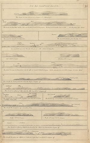
Condición: Good. ENGLAND SOUTH COAST PROFILE Kent Sussex IOW Dorset Devon COLLINS 1693 old map. Decorative antique eighteenth century copperplate navigational aid, printed on thick paper; Captain Greenvile (or Greenville) Collins. Collins was an officer of the Royal Navy and prominent hydrographer, who was commissioned by King Charles II in 1676 and appointed by Samuel Pepys (then Secretary to the Admiralty), to chart the coasts of Great Britain. The resulting atlas - Great Britain's Coasting Pilot - was the first original sea atlas to be produced by an Englishman. Prior to publication of these maps, nautical charts were often defective, and there was no centralised system for collecting and disseminating the better maps made by experienced seamen. In 1681, Collins gained the king's preferment to survey the country's coasts. The Admiralty supplied Collins with the 8-gun yacht HMSMerlin for the first two years and later the yacht HMSMonmouth until 1686. His work was carried out under the supervision of Trinity House, who also supported the project financially. Samuel Pepys insisted that Collins be made a younger brother of Trinity House. Collins spent seven years on the survey, the first edition of which was published in 1693, as "Great Britain's Coasting Pilot". The charts, while not completely accurate, were an enormous advance on anything before them, entitling Collins to rank as not only one of the earliest, but also among the best of English hydrographers. Twenty-one further editions were published during the eighteenth century. (1693 (First edition)). 45.5 x 29.0cm, 17.75 x 11.5 inches. Condition: Good. There is nothing printed on the reverse side, which is plain. The sheet depicts coastal recognition profiles for key sections of and features along the coast of southern England (Kent, Sussex, the Isle of Wight, Dorset and Devon), including Walmer Castle, South Foreland, Beachy Head and the Seven Sisters, the Isle of Wight, Portland and Dartmouth.
-
The South Part of the isles of Shetland - Is dedicated and presented to Mr John Colson teacher of the Mathematicks in London by Capt. Greenvile Collins
Ańo de publicación: 1693
Mapa Original o primera edición
Condición: Good. The South Part of the isles of Shetland sea chart. Lerwick. COLLINS 1693 map. Decorative antique eighteenth century copperplate nautical sea chart, printed on thick paper; Captain Greenvile (or Greenville) Collins. Collins was an officer of the Royal Navy and prominent hydrographer, who was commissioned by King Charles II in 1676 and appointed by Samuel Pepys (then Secretary to the Admiralty), to chart the coasts of Great Britain. The resulting atlas - Great Britain's Coasting Pilot - was the first original sea atlas to be produced by an Englishman. Prior to publication of these maps, nautical charts were often defective, and there was no centralised system for collecting and disseminating the better maps made by experienced seamen. In 1681, Collins gained the king's preferment to survey the country's coasts. The Admiralty supplied Collins with the 8-gun yacht HMSMerlin for the first two years and later the yacht HMSMonmouth until 1686. His work was carried out under the supervision of Trinity House, who also supported the project financially. Samuel Pepys insisted that Collins be made a younger brother of Trinity House. Collins spent seven years on the survey, the first edition of which was published in 1693, as "Great Britain's Coasting Pilot". The charts, while not completely accurate, were an enormous advance on anything before them, entitling Collins to rank as not only one of the earliest, but also among the best of English hydrographers. Twenty-one further editions were published during the eighteenth century. (1693 (First edition)). 46.5 x 58.0cm, 18.25 x 23 inches; this is a folding map. Condition: Good. Light spotting. Repaired worm holes in margins (outside the borders of the map). Toning. There is nothing printed on the reverse side, which is plain. The map shows the southern part of the Shetland islands, orientated towards the west. Lerwick & Bressay are shown in the lower part of the right hand side.
-
![Imagen del vendedor de [Part of the Maine Island of Shetland] - To the Rt Honorable Daniel Earle of Nottingham this chart is most humbly dedicated & presented by Capt. Greenvile Collins, Hydroghe. to the King a la venta por Antiqua Print Gallery](https://pictures.abebooks.com/inventory/md/md31458325942.jpg)
[Part of the Maine Island of Shetland] - To the Rt Honorable Daniel Earle of Nottingham this chart is most humbly dedicated & presented by Capt. Greenvile Collins, Hydroghe. to the King
Ańo de publicación: 1693
Mapa Original o primera edición
Condición: Good. Part of the Maine Island of Shetland sea chart. Lerwick Bressay COLLINS 1693 map. Decorative antique eighteenth century copperplate nautical sea chart, printed on thick paper; Captain Greenvile (or Greenville) Collins. Collins was an officer of the Royal Navy and prominent hydrographer, who was commissioned by King Charles II in 1676 and appointed by Samuel Pepys (then Secretary to the Admiralty), to chart the coasts of Great Britain. The resulting atlas - Great Britain's Coasting Pilot - was the first original sea atlas to be produced by an Englishman. Prior to publication of these maps, nautical charts were often defective, and there was no centralised system for collecting and disseminating the better maps made by experienced seamen. In 1681, Collins gained the king's preferment to survey the country's coasts. The Admiralty supplied Collins with the 8-gun yacht HMSMerlin for the first two years and later the yacht HMSMonmouth until 1686. His work was carried out under the supervision of Trinity House, who also supported the project financially. Samuel Pepys insisted that Collins be made a younger brother of Trinity House. Collins spent seven years on the survey, the first edition of which was published in 1693, as "Great Britain's Coasting Pilot". The charts, while not completely accurate, were an enormous advance on anything before them, entitling Collins to rank as not only one of the earliest, but also among the best of English hydrographers. Twenty-one further editions were published during the eighteenth century. (1693 (First edition)). 47.0 x 59.0cm, 18.5 x 23 inches; this is a folding map. Condition: Good. Repaired worm holes in margins (outside the borders of the map). There is nothing printed on the reverse side, which is plain. The map is orientated toward the west. The island of Bressay, with Lerwick opposite are shown on the left hand side of the chart. The main island runs across the top part of the map.
-
Holy-Head - Is most humbly dedicated to Capt. William Wright by G Collins, Hydrographer to the King
Ańo de publicación: 1774
Mapa Original o primera edición
Condición: Good. 'Holy-Head' sea chart. Holy Island & HOLYHEAD, Anglesey. Capt. COLLINS c1774 map. Decorative antique eighteenth century copperplate nautical sea chart, printed on thick paper; Captain Greenvile (or Greenville) Collins. Collins was an officer of the Royal Navy and prominent hydrographer, who was commissioned by King Charles II in 1676 and appointed by Samuel Pepys (then Secretary to the Admiralty), to chart the coasts of Great Britain. The resulting atlas - Great Britain's Coasting Pilot - was the first original sea atlas to be produced by an Englishman. Prior to publication of these maps, nautical charts were often defective, and there was no centralised system for collecting and disseminating the better maps made by experienced seamen. In 1681, Collins gained the king's preferment to survey the country's coasts. The Admiralty supplied Collins with the 8-gun yacht HMSMerlin for the first two years and later the yacht HMSMonmouth until 1686. His work was carried out under the supervision of Trinity House, who also supported the project financially. Samuel Pepys insisted that Collins be made a younger brother of Trinity House. Collins spent seven years on the survey, the first edition of which was published in 1693, as "Great Britain's Coasting Pilot". The charts, while not completely accurate, were an enormous advance on anything before them, entitling Collins to rank as not only one of the earliest, but also among the best of English hydrographers. Twenty-one further editions were published during the eighteenth century. (Published after 1774, possibly in 1792. The atlas within which this map was printed (see provenance) was first published in 1693 with a number of later editions published through the eighteenth century. The publication date stated on the title page of this edition of the atlas is "MDCCLXCII", which is unintelligible and erroneous as it does not conform to standard notation for Roman Numerals. The text within the book from which the map was extracted refers to tidal variations up to the year 1774, hence we state the publication date as after 1774. This edition of the atlas does not appear in the English Short Title Catalogue. The publisher is stated to be "Mount & Davidson", which differs from the publisher of other editions through the early part of the 18th century, which is stated to be "Mount & Page". Mount & Davidson appear to have been active as publishers in the 1780's and early 1790's. A publication date of 1792 (MDCCXCII) would be consistent with stated year of publication if the "L" had been erroneously inserted.). 63.5 x 51.0cm, 25 x 20 inches; this is a folding map. Condition: Good. Please contact us if you would like to arrange to view this map. There is nothing printed on the reverse side, which is plain. Depicted in this sea chart, which is orientated towards the east, is Holy Island, the town and port of Holyhead, and the adjacent coast of Anglesey, Wales.
-
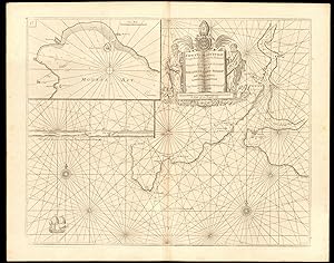
[The Firth of Murry] - To the Rt Honble, my Lord Viscount Torbat, Lord Register of the Kingdom of Scotland, this map is most humbly dedicated & presented by Capt. G. Collins, Hydroghe. to the King. 1689
Ańo de publicación: 1774
Mapa Original o primera edición
Condición: Good. 'Firth of Murry' sea chart. MORAY FIRTH Inverness Cromarty. COLLINS c1774 map. Decorative antique eighteenth century copperplate nautical sea chart, printed on thick paper; Captain Greenvile (or Greenville) Collins. Collins was an officer of the Royal Navy and prominent hydrographer, who was commissioned by King Charles II in 1676 and appointed by Samuel Pepys (then Secretary to the Admiralty), to chart the coasts of Great Britain. The resulting atlas - Great Britain's Coasting Pilot - was the first original sea atlas to be produced by an Englishman. Prior to publication of these maps, nautical charts were often defective, and there was no centralised system for collecting and disseminating the better maps made by experienced seamen. In 1681, Collins gained the king's preferment to survey the country's coasts. The Admiralty supplied Collins with the 8-gun yacht HMSMerlin for the first two years and later the yacht HMSMonmouth until 1686. His work was carried out under the supervision of Trinity House, who also supported the project financially. Samuel Pepys insisted that Collins be made a younger brother of Trinity House. Collins spent seven years on the survey, the first edition of which was published in 1693, as "Great Britain's Coasting Pilot". The charts, while not completely accurate, were an enormous advance on anything before them, entitling Collins to rank as not only one of the earliest, but also among the best of English hydrographers. Twenty-one further editions were published during the eighteenth century. (Published after 1774, possibly in 1792. The atlas within which this map was printed (see provenance) was first published in 1693 with a number of later editions published through the eighteenth century. The publication date stated on the title page of this edition of the atlas is "MDCCLXCII", which is unintelligible and erroneous as it does not conform to standard notation for Roman Numerals. The text within the book from which the map was extracted refers to tidal variations up to the year 1774, hence we state the publication date as after 1774. This edition of the atlas does not appear in the English Short Title Catalogue. The publisher is stated to be "Mount & Davidson", which differs from the publisher of other editions through the early part of the 18th century, which is stated to be "Mount & Page". Mount & Davidson appear to have been active as publishers in the 1780's and early 1790's. A publication date of 1792 (MDCCXCII) would be consistent with stated year of publication if the "L" had been erroneously inserted.). 63.5 x 51.0cm, 25 x 20 inches; this is a folding map. Condition: Good. There are four small, inconspicuous, wormholes which have been professionally restored. Light damp stain in right hand margin, not extending into the printed area. Light toning. Please contact us if you would like to arrange to view this map. There is nothing printed on the reverse side, which is plain. This decorative sea chart shows the Moray Firth, with nautical features such as sand banks and ocean depths, between Helmsdale and Burghead. A number of coastal towns are marked, including Inverness, Fortrose, Cromarty, Tarbet Bay and the Cromarty Firth. The map is orientated towards the west.
-
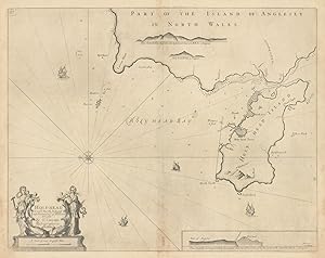
Holy-Head - Is most humbly dedicated to Capt. William Wright by G Collins, Hydrographer to the King
Ańo de publicación: 1723
Mapa Original o primera edición
Condición: Good. Holy-Head sea chart. Holy Island & HOLYHEAD, Anglesey. Capt. COLLINS 1723 map. Decorative antique eighteenth century copperplate nautical sea chart, printed on thick paper; Captain Greenvile (or Greenville) Collins. Collins was an officer of the Royal Navy and prominent hydrographer, who was commissioned by King Charles II in 1676 and appointed by Samuel Pepys (then Secretary to the Admiralty), to chart the coasts of Great Britain. The resulting atlas - Great Britain's Coasting Pilot - was the first original sea atlas to be produced by an Englishman. Prior to publication of these maps, nautical charts were often defective, and there was no centralised system for collecting and disseminating the better maps made by experienced seamen. In 1681, Collins gained the king's preferment to survey the country's coasts. The Admiralty supplied Collins with the 8-gun yacht HMSMerlin for the first two years and later the yacht HMSMonmouth until 1686. His work was carried out under the supervision of Trinity House, who also supported the project financially. Samuel Pepys insisted that Collins be made a younger brother of Trinity House. Collins spent seven years on the survey, the first edition of which was published in 1693, as "Great Britain's Coasting Pilot". The charts, while not completely accurate, were an enormous advance on anything before them, entitling Collins to rank as not only one of the earliest, but also among the best of English hydrographers. Twenty-one further editions were published during the eighteenth century. (1723). 47.0 x 59.0cm, 18.5 x 23.25 inches; this is a folding map. Condition: Good. Please contact us if you would like to arrange to view this map. There is nothing printed on the reverse side, which is plain. Depicted in this sea chart, which is orientated towards the east, is Holy Island, the town and port of Holyhead, and the adjacent coast of Anglesey, Wales.
-
![Imagen del vendedor de [The Firth of Murry] - To the Rt Honble, my Lord Viscount Torbat, Lord Register of the Kingdom of Scotland, this map is most humbly dedicated & presented by Capt. G. Collins, Hydroghe. to the King. 1689 a la venta por Antiqua Print Gallery](https://pictures.abebooks.com/inventory/md/md31175530315.jpg)
[The Firth of Murry] - To the Rt Honble, my Lord Viscount Torbat, Lord Register of the Kingdom of Scotland, this map is most humbly dedicated & presented by Capt. G. Collins, Hydroghe. to the King. 1689
Ańo de publicación: 1723
Mapa Original o primera edición
Condición: Good. Firth of Murry. MORAY FIRTH sea chart Inverness Cromarty. COLLINS 1723 old map. Decorative antique eighteenth century copperplate nautical sea chart, printed on thick paper; Captain Greenvile (or Greenville) Collins. Collins was an officer of the Royal Navy and prominent hydrographer, who was commissioned by King Charles II in 1676 and appointed by Samuel Pepys (then Secretary to the Admiralty), to chart the coasts of Great Britain. The resulting atlas - Great Britain's Coasting Pilot - was the first original sea atlas to be produced by an Englishman. Prior to publication of these maps, nautical charts were often defective, and there was no centralised system for collecting and disseminating the better maps made by experienced seamen. In 1681, Collins gained the king's preferment to survey the country's coasts. The Admiralty supplied Collins with the 8-gun yacht HMSMerlin for the first two years and later the yacht HMSMonmouth until 1686. His work was carried out under the supervision of Trinity House, who also supported the project financially. Samuel Pepys insisted that Collins be made a younger brother of Trinity House. Collins spent seven years on the survey, the first edition of which was published in 1693, as "Great Britain's Coasting Pilot". The charts, while not completely accurate, were an enormous advance on anything before them, entitling Collins to rank as not only one of the earliest, but also among the best of English hydrographers. Twenty-one further editions were published during the eighteenth century. (1723). 46.5 x 58.5cm, 18.25 x 23 inches; this is a folding map. Condition: Good. Light toning adjacent to centrefold. Repaired wormholes. Please contact us if you would like to arrange to view this map. There is nothing printed on the reverse side, which is plain. This decorative sea chart shows the Moray Firth, with nautical features such as sand banks and ocean depths, between Helmsdale and Burghead. A number of coastal towns are marked, including Inverness, Fortrose, Cromarty, Tarbet Bay and the Cromarty Firth. The map is orientated towards the west.
-
![Imagen del vendedor de [The Firth of Murry] - To the Rt Honble, my Lord Viscount Torbat, Lord Register of the Kingdom of Scotland, this map is most humbly dedicated & presented by Capt. G. Collins, Hydroghe. to the King. 1689 a la venta por Antiqua Print Gallery](https://pictures.abebooks.com/inventory/md/md31458313875.jpg)
[The Firth of Murry] - To the Rt Honble, my Lord Viscount Torbat, Lord Register of the Kingdom of Scotland, this map is most humbly dedicated & presented by Capt. G. Collins, Hydroghe. to the King. 1689
Ańo de publicación: 1693
Mapa Original o primera edición
Condición: Good. Firth of Murry. MORAY FIRTH sea chart Inverness Cromarty. COLLINS 1693 old map. Decorative antique eighteenth century copperplate nautical sea chart, printed on thick paper; Captain Greenvile (or Greenville) Collins. Collins was an officer of the Royal Navy and prominent hydrographer, who was commissioned by King Charles II in 1676 and appointed by Samuel Pepys (then Secretary to the Admiralty), to chart the coasts of Great Britain. The resulting atlas - Great Britain's Coasting Pilot - was the first original sea atlas to be produced by an Englishman. Prior to publication of these maps, nautical charts were often defective, and there was no centralised system for collecting and disseminating the better maps made by experienced seamen. In 1681, Collins gained the king's preferment to survey the country's coasts. The Admiralty supplied Collins with the 8-gun yacht HMSMerlin for the first two years and later the yacht HMSMonmouth until 1686. His work was carried out under the supervision of Trinity House, who also supported the project financially. Samuel Pepys insisted that Collins be made a younger brother of Trinity House. Collins spent seven years on the survey, the first edition of which was published in 1693, as "Great Britain's Coasting Pilot". The charts, while not completely accurate, were an enormous advance on anything before them, entitling Collins to rank as not only one of the earliest, but also among the best of English hydrographers. Twenty-one further editions were published during the eighteenth century. (1693 (First edition)). 46.5 x 58.5cm, 18.25 x 23 inches; this is a folding map. Condition: Good. Spot. Small repaired worm holes in margins (outside the borders of the map). Please contact us if you would like to arrange to view this map. There is nothing printed on the reverse side, which is plain. This decorative sea chart shows the Moray Firth, with nautical features such as sand banks and ocean depths, between Helmsdale and Burghead. A number of coastal towns are marked, including Inverness, Fortrose, Cromarty, Tarbet Bay and the Cromarty Firth. The map is orientated towards the west.
-
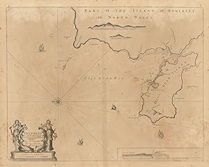
Holy-Head - Is most humbly dedicated to Capt. William Wright by G Collins, Hydrographer to the King
Ańo de publicación: 1693
Mapa Original o primera edición
Condición: Good. Holy-Head sea chart. Holy Island & HOLYHEAD, Anglesey. Capt. COLLINS 1693 map. Decorative antique eighteenth century copperplate nautical sea chart, printed on thick paper; Captain Greenvile (or Greenville) Collins. Collins was an officer of the Royal Navy and prominent hydrographer, who was commissioned by King Charles II in 1676 and appointed by Samuel Pepys (then Secretary to the Admiralty), to chart the coasts of Great Britain. The resulting atlas - Great Britain's Coasting Pilot - was the first original sea atlas to be produced by an Englishman. Prior to publication of these maps, nautical charts were often defective, and there was no centralised system for collecting and disseminating the better maps made by experienced seamen. In 1681, Collins gained the king's preferment to survey the country's coasts. The Admiralty supplied Collins with the 8-gun yacht HMSMerlin for the first two years and later the yacht HMSMonmouth until 1686. His work was carried out under the supervision of Trinity House, who also supported the project financially. Samuel Pepys insisted that Collins be made a younger brother of Trinity House. Collins spent seven years on the survey, the first edition of which was published in 1693, as "Great Britain's Coasting Pilot". The charts, while not completely accurate, were an enormous advance on anything before them, entitling Collins to rank as not only one of the earliest, but also among the best of English hydrographers. Twenty-one further editions were published during the eighteenth century. (1693 (First edition)). 47.0 x 59.0cm, 18.5 x 23.25 inches; this is a folding map. Condition: Good. Light spotting. Please contact us if you would like to arrange to view this map. There is nothing printed on the reverse side, which is plain. Depicted in this sea chart, which is orientated towards the east, is Holy Island, the town and port of Holyhead, and the adjacent coast of Anglesey, Wales.
-
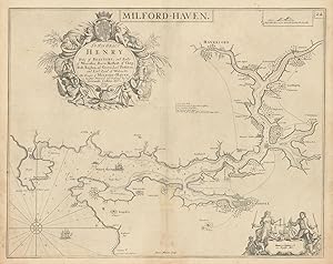
No Binding. Condición: Very Good. Collins, Greenville : Chart of Milford Haven, from Great Britain's Coasting Pilot, ca.1760. Copper engraved chart. Map size approx 560mm x 440mm. Wide margins, hand coloured, good impression on heavy paper, showing the Welsh coast at Milford Haven. Compass rose, rhumb lines, scale. Cartouche with cherub, dedicated to Sir Hugh Owen. Light water stain to top margin just touching printed area, otherwise a very good, bright and attractive chart.
-
Fowey & Mounts-Bay - Is Most Humbly Presented And Dedicates to the Right Reverend Father in God Jonathan Lord Bishop of Bristoll, by Capt. Greenvile Collins, Hydrographr. To the King
Ańo de publicación: 1774
Mapa Original o primera edición
Condición: Good. 'FOWEY & MOUNTS BAY' sea chart. Polruan Bodinnick Penzance. COLLINS c1774 map. Decorative antique eighteenth century copperplate nautical sea chart, printed on thick paper; Captain Greenvile (or Greenville) Collins. Collins was an officer of the Royal Navy and prominent hydrographer, who was commissioned by King Charles II in 1676 and appointed by Samuel Pepys (then Secretary to the Admiralty), to chart the coasts of Great Britain. The resulting atlas - Great Britain's Coasting Pilot - was the first original sea atlas to be produced by an Englishman. Prior to publication of these maps, nautical charts were often defective, and there was no centralised system for collecting and disseminating the better maps made by experienced seamen. In 1681, Collins gained the king's preferment to survey the country's coasts. The Admiralty supplied Collins with the 8-gun yacht HMSMerlin for the first two years and later the yacht HMSMonmouth until 1686. His work was carried out under the supervision of Trinity House, who also supported the project financially. Samuel Pepys insisted that Collins be made a younger brother of Trinity House. Collins spent seven years on the survey, the first edition of which was published in 1693, as "Great Britain's Coasting Pilot". The charts, while not completely accurate, were an enormous advance on anything before them, entitling Collins to rank as not only one of the earliest, but also among the best of English hydrographers. Twenty-one further editions were published during the eighteenth century. (Published after 1774, possibly in 1792. The atlas within which this map was printed (see provenance) was first published in 1693 with a number of later editions published through the eighteenth century. The publication date stated on the title page of this edition of the atlas is "MDCCLXCII", which is unintelligible and erroneous as it does not conform to standard notation for Roman Numerals. The text within the book from which the map was extracted refers to tidal variations up to the year 1774, hence we state the publication date as after 1774. This edition of the atlas does not appear in the English Short Title Catalogue. The publisher is stated to be "Mount & Davidson", which differs from the publisher of other editions through the early part of the 18th century, which is stated to be "Mount & Page". Mount & Davidson appear to have been active as publishers in the 1780's and early 1790's. A publication date of 1792 (MDCCXCII) would be consistent with stated year of publication if the "L" had been erroneously inserted.). 63.5 x 51.0cm, 25 x 20 inches; this is a folding map. Condition: Good. Please contact us if you would like to arrange to view this map. There is nothing printed on the reverse side, which is plain. The chart depicts the Fowey river estuary. A number of features are shown including the towns/villages of Fowey, Polruan, Bodinnick ("Pendennick") and Menabilly. The smaller chart inset in the top left hand corner depicts Mount's Bay, including Penzance, St Michael's Mount, Mousehole and Market Jew (Marazion). Below the insert chart is a coastal recognition profile for the entrance to the Fowey estuary, with Coombe Farm, Fowey Castle, St Catherine's chapel and St Saviour's church (Polruan) marked.
-
Milford Haven and the Islands Adjacent - Most humbly dedicated and presented to Sr. Hugh Owen Bart. by Capt. G. Collins, Hydrographer to their Majesties
Ańo de publicación: 1723
Mapa Original o primera edición
Condición: Good. MILFORD HAVEN & adjacent coast chart. St Brides Bay St Davids. COLLINS 1723 map. Decorative antique eighteenth century copperplate nautical sea chart, printed on thick paper; Captain Greenvile (or Greenville) Collins. Collins was an officer of the Royal Navy and prominent hydrographer, who was commissioned by King Charles II in 1676 and appointed by Samuel Pepys (then Secretary to the Admiralty), to chart the coasts of Great Britain. The resulting atlas - Great Britain's Coasting Pilot - was the first original sea atlas to be produced by an Englishman. Prior to publication of these maps, nautical charts were often defective, and there was no centralised system for collecting and disseminating the better maps made by experienced seamen. In 1681, Collins gained the king's preferment to survey the country's coasts. The Admiralty supplied Collins with the 8-gun yacht HMSMerlin for the first two years and later the yacht HMSMonmouth until 1686. His work was carried out under the supervision of Trinity House, who also supported the project financially. Samuel Pepys insisted that Collins be made a younger brother of Trinity House. Collins spent seven years on the survey, the first edition of which was published in 1693, as "Great Britain's Coasting Pilot". The charts, while not completely accurate, were an enormous advance on anything before them, entitling Collins to rank as not only one of the earliest, but also among the best of English hydrographers. Twenty-one further editions were published during the eighteenth century. (1723). 46.5 x 58.5cm, 18.25 x 23 inches; this is a folding map. Condition: Good. Please contact us if you would like to arrange to view this map. There is nothing printed on the reverse side, which is plain. This decorative nautical chart of the western tip of Pembrokeshire, shows the approaches to Milford Haven, St Bride's Bay, St David's Head, and the adjacent coast. The towns of St David's and St Bride's are marked.
-
![Imagen del vendedor de [Menai Strait] - To the Right Worshipfull Sr William Williams Barri. this is most humbly presented and dedicated by Capt. G. Collins a la venta por Antiqua Print Gallery](https://pictures.abebooks.com/inventory/md/md31458313869.jpg)
[Menai Strait] - To the Right Worshipfull Sr William Williams Barri. this is most humbly presented and dedicated by Capt. G. Collins
Ańo de publicación: 1693
Mapa Original o primera edición
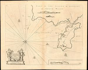
Condición: Good. MENAI STRAIT sea chart. Anglesey Bangor Conwy Caernarfon.COLLINS 1693 old map. Decorative antique eighteenth century copperplate nautical sea chart, printed on thick paper; Captain Greenvile (or Greenville) Collins. Collins was an officer of the Royal Navy and prominent hydrographer, who was commissioned by King Charles II in 1676 and appointed by Samuel Pepys (then Secretary to the Admiralty), to chart the coasts of Great Britain. The resulting atlas - Great Britain's Coasting Pilot - was the first original sea atlas to be produced by an Englishman. Prior to publication of these maps, nautical charts were often defective, and there was no centralised system for collecting and disseminating the better maps made by experienced seamen. In 1681, Collins gained the king's preferment to survey the country's coasts. The Admiralty supplied Collins with the 8-gun yacht HMSMerlin for the first two years and later the yacht HMSMonmouth until 1686. His work was carried out under the supervision of Trinity House, who also supported the project financially. Samuel Pepys insisted that Collins be made a younger brother of Trinity House. Collins spent seven years on the survey, the first edition of which was published in 1693, as "Great Britain's Coasting Pilot". The charts, while not completely accurate, were an enormous advance on anything before them, entitling Collins to rank as not only one of the earliest, but also among the best of English hydrographers. Twenty-one further editions were published during the eighteenth century. (1693 (First edition)). 47.0 x 58.5cm, 18.5 x 23 inches; this is a folding map. Condition: Good. There is nothing printed on the reverse side, which is plain. This attractive navigation chart, orientated towards the south, shows the Menai Strait between Anglesey and Caernarfonshire in north Wales. The towns of Bangor, Conwy, Caernarfon and Beaumaris are marked among others. Inset bottom right on a larger scale is shown Trwyn Du (Dinmor Point), Penmon and Priestholme island (Ynys Seriol, or Puffin Island), at the eastern entrance to the strait.
-
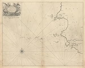
![Imagen del vendedor de [England east coast profiles] a la venta por Antiqua Print Gallery](https://pictures.abebooks.com/inventory/md/md31458313876.jpg)
Condición: Good. GB EAST COAST PROFILES. Norfolk Sunderland Aberdeenshire. COLLINS 1693 old map. Decorative antique eighteenth century copperplate nautical sea chart, printed on thick paper; Captain Greenvile (or Greenville) Collins. Collins was an officer of the Royal Navy and prominent hydrographer, who was commissioned by King Charles II in 1676 and appointed by Samuel Pepys (then Secretary to the Admiralty), to chart the coasts of Great Britain. The resulting atlas - Great Britain's Coasting Pilot - was the first original sea atlas to be produced by an Englishman. Prior to publication of these maps, nautical charts were often defective, and there was no centralised system for collecting and disseminating the better maps made by experienced seamen. In 1681, Collins gained the king's preferment to survey the country's coasts. The Admiralty supplied Collins with the 8-gun yacht HMSMerlin for the first two years and later the yacht HMSMonmouth until 1686. His work was carried out under the supervision of Trinity House, who also supported the project financially. Samuel Pepys insisted that Collins be made a younger brother of Trinity House. Collins spent seven years on the survey, the first edition of which was published in 1693, as "Great Britain's Coasting Pilot". The charts, while not completely accurate, were an enormous advance on anything before them, entitling Collins to rank as not only one of the earliest, but also among the best of English hydrographers. Twenty-one further editions were published during the eighteenth century. (1693 (First edition)). 46.0 x 29.5cm, 18 x 11.5 inches. Condition: Good. There is nothing printed on the reverse side, which is plain. The sheet depicts coastal recognition profiles for key sections of and features along the coast of eastern England and Scotland, including Dunwich, Southwold, Lowestoft, Cromer, Blakeney (Norfolk); Spurn Point, Flamborough Head, Teeside, Hartlepool, Sunderland, Tantallon, Peterhead, Aberdeen.
-
Milford Haven and the Islands Adjacent - Most humbly dedicated and presented to Sr. Hugh Owen Bart. by Capt. G. Collins, Hydrographer to their Majesties
Ańo de publicación: 1693
Mapa Original o primera edición
Condición: Good. MILFORD HAVEN & adjacent coast chart. St Brides Bay St Davids. COLLINS 1693 map. Decorative antique eighteenth century copperplate nautical sea chart, printed on thick paper; Captain Greenvile (or Greenville) Collins. Collins was an officer of the Royal Navy and prominent hydrographer, who was commissioned by King Charles II in 1676 and appointed by Samuel Pepys (then Secretary to the Admiralty), to chart the coasts of Great Britain. The resulting atlas - Great Britain's Coasting Pilot - was the first original sea atlas to be produced by an Englishman. Prior to publication of these maps, nautical charts were often defective, and there was no centralised system for collecting and disseminating the better maps made by experienced seamen. In 1681, Collins gained the king's preferment to survey the country's coasts. The Admiralty supplied Collins with the 8-gun yacht HMSMerlin for the first two years and later the yacht HMSMonmouth until 1686. His work was carried out under the supervision of Trinity House, who also supported the project financially. Samuel Pepys insisted that Collins be made a younger brother of Trinity House. Collins spent seven years on the survey, the first edition of which was published in 1693, as "Great Britain's Coasting Pilot". The charts, while not completely accurate, were an enormous advance on anything before them, entitling Collins to rank as not only one of the earliest, but also among the best of English hydrographers. Twenty-one further editions were published during the eighteenth century. (1693 (First edition)). 46.5 x 58.5cm, 18.25 x 23 inches; this is a folding map. Condition: Good. Light spotting. Please contact us if you would like to arrange to view this map. There is nothing printed on the reverse side, which is plain. This decorative nautical chart of the western tip of Pembrokeshire, shows the approaches to Milford Haven, St Bride's Bay, St David's Head, and the adjacent coast. The towns of St David's and St Bride's are marked.
-
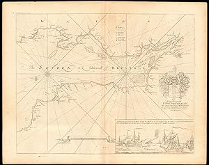
The Severn or Channell of Bristoll - To the Right Honourable Sr. Robt. Southwell Kt. Who attended his Majty. K. William the 3d in his Expedition for Ireland in Quality of Principall Secretary of State for that Kingdom
Ańo de publicación: 1774
Mapa Original o primera edición
Condición: Good. 'The Severn or Channell of Bristoll' sea/estuary chart by Capt COLLINS c1774 map. Decorative antique eighteenth century copperplate nautical sea chart, printed on thick paper; Captain Greenvile (or Greenville) Collins. Collins was an officer of the Royal Navy and prominent hydrographer, who was commissioned by King Charles II in 1676 and appointed by Samuel Pepys (then Secretary to the Admiralty), to chart the coasts of Great Britain. The resulting atlas - Great Britain's Coasting Pilot - was the first original sea atlas to be produced by an Englishman. Prior to publication of these maps, nautical charts were often defective, and there was no centralised system for collecting and disseminating the better maps made by experienced seamen. In 1681, Collins gained the king's preferment to survey the country's coasts. The Admiralty supplied Collins with the 8-gun yacht HMSMerlin for the first two years and later the yacht HMSMonmouth until 1686. His work was carried out under the supervision of Trinity House, who also supported the project financially. Samuel Pepys insisted that Collins be made a younger brother of Trinity House. Collins spent seven years on the survey, the first edition of which was published in 1693, as "Great Britain's Coasting Pilot". The charts, while not completely accurate, were an enormous advance on anything before them, entitling Collins to rank as not only one of the earliest, but also among the best of English hydrographers. Twenty-one further editions were published during the eighteenth century. (Published after 1774, possibly in 1792. The atlas within which this map was printed (see provenance) was first published in 1693 with a number of later editions published through the eighteenth century. The publication date stated on the title page of this edition of the atlas is "MDCCLXCII", which is unintelligible and erroneous as it does not conform to standard notation for Roman Numerals. The text within the book from which the map was extracted refers to tidal variations up to the year 1774, hence we state the publication date as after 1774. This edition of the atlas does not appear in the English Short Title Catalogue. The publisher is stated to be "Mount & Davidson", which differs from the publisher of other editions through the early part of the 18th century, which is stated to be "Mount & Page". Mount & Davidson appear to have been active as publishers in the 1780's and early 1790's. A publication date of 1792 (MDCCXCII) would be consistent with stated year of publication if the "L" had been erroneously inserted.). 63.5 x 51.0cm, 25 x 20 inches; this is a folding map. Condition: Good. Please contact us if you would like to arrange to view this map. There is nothing printed on the reverse side, which is plain. This beautiful nautical chart shows the Bristol Channel and Severn Estuary with the adjacent coasts of South Wales, Gloucestershire, Somerset & Devon. The chart features a decorative coat of arms and inset at bottom right, it depicts King William III's return from Ireland during the Williamite War with the inscription: 'At Shere hampton near King Road, landed his Majtie. on the 6t of Septr. 1690 he sailed in 27 hours from Duncannon Fort to King Road and lay that night at Kings Weston at the house of Sr Robert Southwell', to whom the map is dedicated.
-
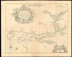
Milford Haven - To His Grace Henry Duke of Beaufort, and Earle of Worcester, Baron Herbert of Chepstoll, Raglan and Gower, Lord President and Lord Lieut. of Wales &c. This draught of Milford-Haven is humbly dedicated and presented by Capt. Greenvile Collins, Hydr. to ye KIng
Ańo de publicación: 1774
Mapa Original o primera edición
Condición: Good. 'Milford Haven' sea chart. Haverfordwest Pembroke Daugleddau. COLLINS c1774 map. Decorative antique eighteenth century copperplate nautical sea chart, printed on thick paper; Captain Greenvile (or Greenville) Collins. Collins was an officer of the Royal Navy and prominent hydrographer, who was commissioned by King Charles II in 1676 and appointed by Samuel Pepys (then Secretary to the Admiralty), to chart the coasts of Great Britain. The resulting atlas - Great Britain's Coasting Pilot - was the first original sea atlas to be produced by an Englishman. Prior to publication of these maps, nautical charts were often defective, and there was no centralised system for collecting and disseminating the better maps made by experienced seamen. In 1681, Collins gained the king's preferment to survey the country's coasts. The Admiralty supplied Collins with the 8-gun yacht HMSMerlin for the first two years and later the yacht HMSMonmouth until 1686. His work was carried out under the supervision of Trinity House, who also supported the project financially. Samuel Pepys insisted that Collins be made a younger brother of Trinity House. Collins spent seven years on the survey, the first edition of which was published in 1693, as "Great Britain's Coasting Pilot". The charts, while not completely accurate, were an enormous advance on anything before them, entitling Collins to rank as not only one of the earliest, but also among the best of English hydrographers. Twenty-one further editions were published during the eighteenth century. (Published after 1774, possibly in 1792. The atlas within which this map was printed (see provenance) was first published in 1693 with a number of later editions published through the eighteenth century. The publication date stated on the title page of this edition of the atlas is "MDCCLXCII", which is unintelligible and erroneous as it does not conform to standard notation for Roman Numerals. The text within the book from which the map was extracted refers to tidal variations up to the year 1774, hence we state the publication date as after 1774. This edition of the atlas does not appear in the English Short Title Catalogue. The publisher is stated to be "Mount & Davidson", which differs from the publisher of other editions through the early part of the 18th century, which is stated to be "Mount & Page". Mount & Davidson appear to have been active as publishers in the 1780's and early 1790's. A publication date of 1792 (MDCCXCII) would be consistent with stated year of publication if the "L" had been erroneously inserted.). 63.5 x 51.0cm, 25 x 20 inches; this is a folding map. Condition: Good. Light toning. Please contact us if you would like to arrange to view this map. There is nothing printed on the reverse side, which is plain. This magnificent sea chart shows the harbour of Milford haven in Pembrokeshire, the Daugleddau estuary, and the eastern and western Cleddau rivers. A number of towns and villages are marked including Haverford (Haverfordwest) & Pembroke.
-
City of Aberdeene - To the Honble. The Magistrates of the Citty of Aberdeene. This map is most humbly dedicated & presented by Capt. G. Collins Hydrographer to the King
Ańo de publicación: 1774
Mapa Original o primera edición
Condición: Good. Approaches to ABERDEEN, DUNDEE & MONTROSE sea chart. Tay. COLLINS c1774 map. Decorative antique eighteenth century copperplate nautical sea chart, printed on thick paper; Captain Greenvile (or Greenville) Collins. Collins was an officer of the Royal Navy and prominent hydrographer, who was commissioned by King Charles II in 1676 and appointed by Samuel Pepys (then Secretary to the Admiralty), to chart the coasts of Great Britain. The resulting atlas - Great Britain's Coasting Pilot - was the first original sea atlas to be produced by an Englishman. Prior to publication of these maps, nautical charts were often defective, and there was no centralised system for collecting and disseminating the better maps made by experienced seamen. In 1681, Collins gained the king's preferment to survey the country's coasts. The Admiralty supplied Collins with the 8-gun yacht HMSMerlin for the first two years and later the yacht HMSMonmouth until 1686. His work was carried out under the supervision of Trinity House, who also supported the project financially. Samuel Pepys insisted that Collins be made a younger brother of Trinity House. Collins spent seven years on the survey, the first edition of which was published in 1693, as "Great Britain's Coasting Pilot". The charts, while not completely accurate, were an enormous advance on anything before them, entitling Collins to rank as not only one of the earliest, but also among the best of English hydrographers. Twenty-one further editions were published during the eighteenth century. (Published after 1774, possibly in 1792. The atlas within which this map was printed (see provenance) was first published in 1693 with a number of later editions published through the eighteenth century. The publication date stated on the title page of this edition of the atlas is "MDCCLXCII", which is unintelligible and erroneous as it does not conform to standard notation for Roman Numerals. The text within the book from which the map was extracted refers to tidal variations up to the year 1774, hence we state the publication date as after 1774. This edition of the atlas does not appear in the English Short Title Catalogue. The publisher is stated to be "Mount & Davidson", which differs from the publisher of other editions through the early part of the 18th century, which is stated to be "Mount & Page". Mount & Davidson appear to have been active as publishers in the 1780's and early 1790's. A publication date of 1792 (MDCCXCII) would be consistent with stated year of publication if the "L" had been erroneously inserted.). 63.5 x 51.0cm, 25 x 20 inches; this is a folding map. Condition: Good. There are two wormholes c25mm long within the border of the map which have been professionally restored. Damp staining in the margin, not extending into the printed area. Please contact us if you would like to arrange to view this map. There is nothing printed on the reverse side, which is plain. This decorative navigational chart depicts three river estuaries of the east coast of Scotland, with the towns at each of their mouth. The main chart shows the Tay estuary with the city of Dundee and the adjacent sea coast from Fissnesse to Montrose, including the towns of Arbroath, St Andrews and Crail. Inset in the top left hand corner is the Dee Estuary and the city of Aberdeen. In the top right is the River South Esk estuary with the town of Montrose. The maps are all orientated towards the west.
-
Fowey & Mounts Bay - Is most humbly presented and dedicated to the Right Reverend Father in God Jonathan Lord Bishop of Bristoll, by Capt. Greenvile Collins, Hydrographr. To the King
Ańo de publicación: 1723
Mapa Original o primera edición
Condición: Good. FOWEY & MOUNTS BAY sea chart. Polruan Bodinnick Penzance. COLLINS 1723 old map. Decorative antique eighteenth century copperplate nautical sea chart, printed on thick paper; Captain Greenvile (or Greenville) Collins. Collins was an officer of the Royal Navy and prominent hydrographer, who was commissioned by King Charles II in 1676 and appointed by Samuel Pepys (then Secretary to the Admiralty), to chart the coasts of Great Britain. The resulting atlas - Great Britain's Coasting Pilot - was the first original sea atlas to be produced by an Englishman. Prior to publication of these maps, nautical charts were often defective, and there was no centralised system for collecting and disseminating the better maps made by experienced seamen. In 1681, Collins gained the king's preferment to survey the country's coasts. The Admiralty supplied Collins with the 8-gun yacht HMSMerlin for the first two years and later the yacht HMSMonmouth until 1686. His work was carried out under the supervision of Trinity House, who also supported the project financially. Samuel Pepys insisted that Collins be made a younger brother of Trinity House. Collins spent seven years on the survey, the first edition of which was published in 1693, as "Great Britain's Coasting Pilot". The charts, while not completely accurate, were an enormous advance on anything before them, entitling Collins to rank as not only one of the earliest, but also among the best of English hydrographers. Twenty-one further editions were published during the eighteenth century. (1723). 47.0 x 58.5cm, 18.5 x 23 inches; this is a folding map. Condition: Good. Please contact us if you would like to arrange to view this map. There is nothing printed on the reverse side, which is plain. The chart depicts the Fowey river estuary. A number of features are shown including the towns/villages of Fowey, Polruan, Bodinnick ("Pendennick") and Menabilly. The smaller chart inset in the top left hand corner depicts Mount's Bay, including Penzance, St Michael's Mount, Mousehole and Market Jew (Marazion). Below the insert chart is a coastal recognition profile for the entrance to the Fowey estuary, with Coombe Farm, Fowey Castle, St Catherine's chapel and St Saviour's church (Polruan) marked.
-
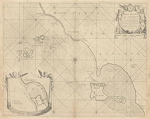
Holy Island Staples and Barwick - Is most humbly dedicated and presented to Capt. Will. Davies Vice Admirall to the Rt. Honorable the Earle of Torrington by Capt. Greenvile Collins, Hydrogr. to the King
Ańo de publicación: 1723
Mapa Original o primera edición
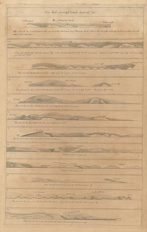
Condición: Good. Holy Island, Staples & Barwick. Lindisfarne Farne Is Berwick. COLLINS 1723 map. Decorative antique eighteenth century copperplate nautical sea chart, printed on thick paper; Captain Greenvile (or Greenville) Collins. Collins was an officer of the Royal Navy and prominent hydrographer, who was commissioned by King Charles II in 1676 and appointed by Samuel Pepys (then Secretary to the Admiralty), to chart the coasts of Great Britain. The resulting atlas - Great Britain's Coasting Pilot - was the first original sea atlas to be produced by an Englishman. Prior to publication of these maps, nautical charts were often defective, and there was no centralised system for collecting and disseminating the better maps made by experienced seamen. In 1681, Collins gained the king's preferment to survey the country's coasts. The Admiralty supplied Collins with the 8-gun yacht HMSMerlin for the first two years and later the yacht HMSMonmouth until 1686. His work was carried out under the supervision of Trinity House, who also supported the project financially. Samuel Pepys insisted that Collins be made a younger brother of Trinity House. Collins spent seven years on the survey, the first edition of which was published in 1693, as "Great Britain's Coasting Pilot". The charts, while not completely accurate, were an enormous advance on anything before them, entitling Collins to rank as not only one of the earliest, but also among the best of English hydrographers. Twenty-one further editions were published during the eighteenth century. (1723). 46.0 x 58.0cm, 18 x 22.75 inches; this is a folding map. Condition: Good. Repaired wormholes. Please contact us if you would like to arrange to view this map. There is nothing printed on the reverse side, which is plain. This fabulous sea chart, which is orientated towards the south, shows Holy Island (Lindisfarne) with the Farne Islands, the adjacent Northumberland coast and inset a plan of Barwick (Berwick-upon-Tweed). Bamburgh Castle, ocean depths, and the sands around Lindisfarne are indicated.
-
![Imagen del vendedor de [The Severn or Channell of Bristoll] To the Right Honourable Sr. Robt. Southwell Kt. Who attended his Majty. K. William the 3d in his Expedition for Ireland in Quality of Principall Secretary of State for that Kingdom a la venta por Antiqua Print Gallery](https://pictures.abebooks.com/inventory/md/md31175524479.jpg)
[The Severn or Channell of Bristoll] To the Right Honourable Sr. Robt. Southwell Kt. Who attended his Majty. K. William the 3d in his Expedition for Ireland in Quality of Principall Secretary of State for that Kingdom
Ańo de publicación: 1723
Mapa Original o primera edición
Condición: Good. The Severn or Channell of Bristoll sea/estuary chart by Capt COLLINS 1723 map. Decorative antique eighteenth century copperplate nautical sea chart, printed on thick paper; Captain Greenvile (or Greenville) Collins. Collins was an officer of the Royal Navy and prominent hydrographer, who was commissioned by King Charles II in 1676 and appointed by Samuel Pepys (then Secretary to the Admiralty), to chart the coasts of Great Britain. The resulting atlas - Great Britain's Coasting Pilot - was the first original sea atlas to be produced by an Englishman. Prior to publication of these maps, nautical charts were often defective, and there was no centralised system for collecting and disseminating the better maps made by experienced seamen. In 1681, Collins gained the king's preferment to survey the country's coasts. The Admiralty supplied Collins with the 8-gun yacht HMSMerlin for the first two years and later the yacht HMSMonmouth until 1686. His work was carried out under the supervision of Trinity House, who also supported the project financially. Samuel Pepys insisted that Collins be made a younger brother of Trinity House. Collins spent seven years on the survey, the first edition of which was published in 1693, as "Great Britain's Coasting Pilot". The charts, while not completely accurate, were an enormous advance on anything before them, entitling Collins to rank as not only one of the earliest, but also among the best of English hydrographers. Twenty-one further editions were published during the eighteenth century. (1723). 46.5 x 59.0cm, 18.25 x 23 inches; this is a folding map. Condition: Good. Please contact us if you would like to arrange to view this map. There is nothing printed on the reverse side, which is plain. This beautiful nautical chart shows the Bristol Channel and Severn Estuary with the adjacent coasts of South Wales, Gloucestershire, Somerset & Devon. The chart features a decorative coat of arms and inset at bottom right, it depicts King William III's return from Ireland during the Williamite War with the inscription: 'At Shere hampton near King Road, landed his Majtie. on the 6t of Septr. 1690 he sailed in 27 hours from Duncannon Fort to King Road and lay that night at Kings Weston at the house of Sr Robert Southwell', to whom the map is dedicated.
-
Milford Haven - To His Grace Henry Duke of Beaufort, and Earle of Worcester, Baron Herbert of Chepstoll, Raglan and Gower, Lord President and Lord Lieut. of Wales &c. This draught of Milford-Haven is humbly dedicated and presented by Capt. Greenvile Collins, Hydr. to ye KIng
Ańo de publicación: 1723
Mapa Original o primera edición
Condición: Good. Milford Haven sea chart. Haverfordwest Pembrokeshire. COLLINS 1723 old map. Decorative antique eighteenth century copperplate nautical sea chart, printed on thick paper; Captain Greenvile (or Greenville) Collins. Collins was an officer of the Royal Navy and prominent hydrographer, who was commissioned by King Charles II in 1676 and appointed by Samuel Pepys (then Secretary to the Admiralty), to chart the coasts of Great Britain. The resulting atlas - Great Britain's Coasting Pilot - was the first original sea atlas to be produced by an Englishman. Prior to publication of these maps, nautical charts were often defective, and there was no centralised system for collecting and disseminating the better maps made by experienced seamen. In 1681, Collins gained the king's preferment to survey the country's coasts. The Admiralty supplied Collins with the 8-gun yacht HMSMerlin for the first two years and later the yacht HMSMonmouth until 1686. His work was carried out under the supervision of Trinity House, who also supported the project financially. Samuel Pepys insisted that Collins be made a younger brother of Trinity House. Collins spent seven years on the survey, the first edition of which was published in 1693, as "Great Britain's Coasting Pilot". The charts, while not completely accurate, were an enormous advance on anything before them, entitling Collins to rank as not only one of the earliest, but also among the best of English hydrographers. Twenty-one further editions were published during the eighteenth century. (1723). 47.0 x 59.5cm, 18.5 x 23.25 inches; this is a folding map. Condition: Good. Spot. Please contact us if you would like to arrange to view this map. There is nothing printed on the reverse side, which is plain. This magnificent sea chart shows the harbour of Milford haven in Pembrokeshire, the Daugleddau estuary, and the eastern and western Cleddau rivers. A number of towns and villages are marked including Haverford (Haverfordwest) & Pembroke.

![Imagen del vendedor de [Part of the Maine Island of Shetland] - To the Rt Honorable Daniel Earle of Nottingham this chart is most humbly dedicated & presented by Capt. Greenvile Collins, Hydroghe. to the King a la venta por Antiqua Print Gallery](https://pictures.abebooks.com/inventory/md/md31102183931.jpg)
![Imagen del vendedor de [The Firth of Murry] - To the Rt Honble, my Lord Viscount Torbat, Lord Register of the Kingdom of Scotland, this map is most humbly dedicated & presented by Capt. G. Collins, Hydroghe. to the King. 1689 a la venta por Antiqua Print Gallery](https://pictures.abebooks.com/inventory/md/md31102181986.jpg)