Importe total (1 artículo artículos):
Destino del pedido:

GEORGE GOODALL AND H C DARBY (5 resultados)
Ir a los resultados principales
Tipo de artículo
- Todo tipo de artículos
- Libros (5)
- Revistas y publicaciones
- Cómics
- Partituras
- Arte, grabados y pósters
- Fotografías
- Mapas
-
Manuscritos y
coleccionismo de papel
Condición
- Todo
- Nuevos
- Antiguos o usados
Encuadernación
- Todo
- Tapa dura (4)
- Tapa blanda
Más atributos
- Primera edición
- Firmado
- Sobrecubierta
- Con imágenes del vendedor (3)
- Sin impresión bajo demanda
Ubicación del vendedor
Valoración de los vendedores
-

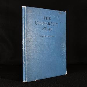
The University Atlas
Publicado por Denoyer-Geppert Company, Chicago, 1944
Librería: Thomas Rightmyer, Asheville, NC, Estados Unidos de America
Valoración del vendedor:

Libro
Hardcover. Condición: Good. No Jacket. 3rd Edition. Large atlas, 14.75 x 11 inches, 96 pages of full color maps plus 16 pages of introduction and temperature, pressure and rainfall graphs of cities world wide plus 36 pages index. Printed by George Philip, London, with Denoyer-Geppert label as publisher's name on title page. Third edition. Blue cloth binding with a few stains and water damage top left. Clean copy not ex-library.
-
Hardcover. Condición: Very Good. No Jacket. George Philip, London, 1953. Hard cover. Book Condition : Very good. A very clean unmarked copy. Previous owners signature inside cover. Spine worn. Heavy by may incur extra postage. Book will be sent by UK postal service. Inventory #016236.
-
Hardcover. Condición: Fair. 3rd Edition. Very large-format HB in red cloth boards with spine gone and boards scuffed & corners rubbed, etc. Some marks to front endpapers but no inscriptions and all inside pages are clean. xvi. plus 116 pages of colour maps plus 36pp. University Atlas Index **HEAVY - EXTRA SHIPPING CHARGES WILL APPLY**.
-

The University Atlas.
Publicado por London; George Philip and Son, Ltd.; 1948., 1948
Librería: Time Booksellers, Somerville, VIC, Australia
Miembro de asociación: ANZAAB ILAB
Valoración del vendedor:

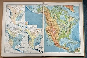
Sixth Edition; Cr. Folio; pp. xvi, 96, 36; 96 full page coloured maps, introduction illustrated with numerous diagrams and charts, 36 page index, bound in green cloth, title lettered in gilt on spine, very good copy.
-
The University Atlas
Publicado por George Philip and Son, London, 1948
Cloth. Condición: Good. Not Stated Ilustrador. Sixth edition of this complete atlas by Goodall and Darby. A university atlas edited by George Goodall and H. C. Darby, consisting of a study in compromise evolving many practical and academic issues. Featuring general maps illustrative of the basic distributions important in the study of geography; large-scale maps providing detailed surveys of the relief of important areas and countries; large-scale maps, physically coloured, containing important material for studies of the home countries; and a reference index to the names that appear on the maps. The sixth edition, an uncommon volume. Collated, complete with ninety-six coloured maps. In the original publisher's full cloth binding. Externally sound with shelf wear, chipped to head and tail of spine and extremities of boards, general light soiling, some damp marking to front board, Internally, binding generally firm. Pages bright and clean. With ninety-six coloured maps. Collated, complete. Good. book.