
Importe total (1 artículo artículos):
Destino del pedido:

ENGRAVED BY LOWRY, JOSEPH WILSON (2 resultados)
Ir a los resultados principales
Tipo de artículo
- Todo tipo de artículos
- Libros (2)
- Revistas y publicaciones
- Cómics
- Partituras
- Arte, grabados y pósters
- Fotografías
- Mapas
-
Manuscritos y
coleccionismo de papel
Condición
- Todo
- Nuevos
- Antiguos o usados
Encuadernación
- Todo
- Tapa dura
- Tapa blanda
Más atributos
- Primera edición
- Firmado
- Sobrecubierta
- Con imágenes del vendedor
- Sin impresión bajo demanda
Ubicación del vendedor
Valoración de los vendedores
-
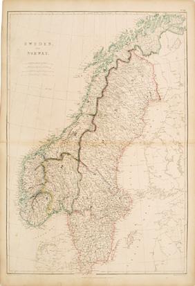
SWEDEN AND NORWAY XII.
Publicado por THE IMPERIAL ATLAS OF MODERN GEOGRAPHY; AN EXTENSIVE SERIES OF MAPS, EMBRACING THE MOST RECENT DISCOVERIES AND THE LATEST POLITICAL DIVISIONS OF TERRITORY IN ALL PARTS OF THE WORLD. Walter Grahame Blackie. 1860, 1860
Librería: Peter Harrington. ABA/ ILAB., London, Reino Unido
Miembro de asociación: ABA ILAB PBFA
Valoración del vendedor:

Detailed map of Sweden and Norway. Title near upper left corner with scale underneath. Copper engraving. Original outline colour. Good condition. Minor split on the centre-fold. Size: 34 x 49.5 cm. (13˝ x 19˝ inches).
-

The United States of North America, Pacific States
Publicado por The Imperial Atlas of Modern Geography; an extensive series of maps, embracing the most recent discoveries and the latest political divisions of territory in all parts of the World. Walter Grahame Blackie. 1860, 1860
Librería: Peter Harrington. ABA/ ILAB., London, Reino Unido
Miembro de asociación: ABA ILAB PBFA
Valoración del vendedor:
Lovely map of the west coast showing Washington, Oregon, California, Utah and New Mexico. Title at bottom left with scale below. Copper engraving. Original outline colour. Very good condition. Size: 34 x 25 cm (13 ˝ x 10 inches).