
Importe total (1 artículo artículos):
Destino del pedido:

DIEZ, FM (8 resultados)
Ir a los resultados principales
Tipo de artículo
- Todo tipo de artículos
- Libros (6)
- Revistas y publicaciones
- Cómics
- Partituras
- Arte, grabados y pósters
- Fotografías
- Mapas (2)
-
Manuscritos y
coleccionismo de papel
Condición
- Todo
- Nuevos
- Antiguos o usados
Encuadernación
- Todo
- Tapa dura (7)
- Tapa blanda
Más atributos
- Primera edición (1)
- Firmado
- Sobrecubierta
- Con imágenes del vendedor (2)
- Sin impresión bajo demanda
Ubicación del vendedor
Valoración de los vendedores
-

Post-und Eisenbahn-Karte von Deutschland und den anliegenden Ländern
Publicado por Gotha, Perthes,, 1860
Librería: Antiquariat am Roßacker, Rosenheim, Alemania
Valoración del vendedor:

Libro
Titelseite, kolorierte Hauptkarte ( 63 x 50 cm.), gefaltet ( 15 Segmente auf Leinen und 1 ergänzende Karte "Ostpreussen"), gut erhalten Sprache: Deutsch Gewicht in Gramm: 550 Kl.-8°, Orig.Leinen mit goldfarb. Titel.
-
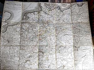
Post- und Reise-Karte von Deutschland und den anliegenden Ländern für Extraposten, Couriere, Diligencen und Eilwagen, mit Bezeichnungen der Eisenbahenen
Publicado por Gotha Justus Perthes (Original not a reprint), 1845
Librería: Versandantiquariat Karin Dykes, Nürnberg, Alemania
Valoración del vendedor:
Mapa
Leineneinband. Ausklappbare in 15 Segmenten auf Leinen gezog. Landkarte, Hardcover, 52,5 x 62,5cm, Cover berieben und lichtverfärbt, Leinen hinten fleckig, normale Gebrauchsspuren, guter altersgem. Zustand. German map with 15 segments mounted on linen, hardcover, 52,5 x With the 1845 railway lines of Germany-Austria and parts of the Netherlands, Belgium, France, Italy and Hungary. 140 gr.
-
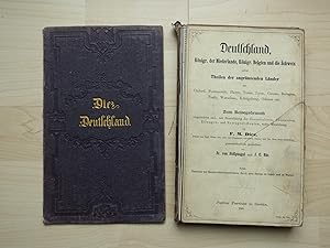
Deutschland, Königr. Der Niederlande, Königr. Belgien und die Schweiz nebst Theilen der angränzenden Länder bis Oxford, Portsmouth, Havre, . Königsberg, Odense etc. Zum Reisegebrauch eingerichtet und, mit Bezeichnung der Eisenbahnen, Chausseen, Eilwagen- und Extrapost-Routen, unter Mitwirkung von FM Diez gemeinschaftlich gezeichnet von Fr. von Stülpnagel und J.C. Bär. Nebst Übersicht der Hauptverbindungsstrassen durch ganz Europa zu Lande und zu Wasser. Justus Perthes Vlg., Gotha 1865. gr.8°, Leinwandeinband, aufklappbare Karte auf Leinwand aufgezogen. Die schöne Karte ist auf fleckiges Leinwand aufgezogen und war wohl in Benutzung. Jedoch gelingt es mir nicht, das Stück aufzuklappen, ohne Leinwandverbindungen aufzureissen. Offenbar hat ein Buchbinder hier Fehler gemacht. Die Karte ist jedoch komplett. Deckel lose, fleckig, Läsuren an Leinwandrpckteilen, sonst gut. Wie gesagt, wie das (offenbar in 3 Reihe aneinanderhängende) Stück ohne Beschädigungen der Leinwandkaschierungen aufgefaltet werden soll, ist mir unklar!.
-
Deutschland, Königr. Der Niederlande, Königr. Belgien und die Schweiz nebst Theilen der angränzenden Länder bis Oxford, Portsmouth, Havre, Königsberg, Odense etc. Zum Reisegebrauch eingerichtet.
Publicado por Justus Perthes, Gotha, 1863
Librería: Lux Mentis, Booksellers, ABAA/ILAB, Portland, ME, Estados Unidos de America
Miembro de asociación: ABAA ILAB
Valoración del vendedor:

Original o primera edición
Full Calf. Condición: Very Good+. [First edition]. [First edition]. Full Calf. Germany, Kingdom. The Netherlands, Kingdom Belgium and Switzerland together with parts of the bordering countries to Oxford, Portsmouth, Havre, Königsberg, Odense, etc. Travel maps with designations of the railways, highways, express wagon and extra post routes, drawn jointly by Fr. von Stülpnagel and JC Bär with the collaboration of FM Diez. In addition to an overview of the main connecting roads throughout Europe on land and water. Justus Perthes Vlg., Gotha 1863. gr.8° Based on Adolf Stieler's large map in 25 sheets. Moderate rubbing to extremities and spine, bumping, weakening hinges, sunned spine and rear, but intact, splitting to upper and lower head and tail, one (detached) loose maps, splitting map leaves, and evidence of dampstaining (discoloration). Pebbled, blind decorative stamped maroon calf over boards, stamped gilt titling. Numerous folding maps mounted on linen. (10? colored maps). Former owner name on tp. Printed endpapers.
-
Deutschland, Königreich der Niederlande, Königeich Belgien und die Schweiz nebst Theilen der angränzenden Länder bis Oxford, Portsmouth, Havre, Tours, Lyon, Genua, Bologna, Pesth, Warschau, Königsberg, Odense etc.
Librería: Redins antikvariat, Enköping, Suecia
Miembro de asociación: ILAB SVAF
Valoración del vendedor:
Zum Reisegebrauch . Gotha, Justus Perthes 1853. Folded engraved map mounted on linen. Together with: Eisenbahn-Atlas in XVI Karten. In original decorated cloth, lower part of spine slightly damaged.[#199850].
-
Carte Routičre de l'Allemagne, des Pays-Bas, de la Belgique, de la Suisse et des Pays Limitrophes jusqu'ŕ Oxford, Portsmouth, Havre, Tours, Lyon, Gčnes, Bologne, Pesth, Varsovie, Koenigsberg, Odense etc.
Publicado por Perthes Justus, Gotha, 1844
Librería: BACCHETTA GIORGIO - ALFEA RARE BOOKS, Milano, Italia
Miembro de asociación: ALAI ILAB
Valoración del vendedor:
Volume: 1 104x84 cm. formato aperto, chiuso cm. 21x13, 32 riquadri su 4 file, su carta a colori applicati su tela, in francese e tedesco, in legatura cartonata, con piatto anteriore staccato, carta molto interessante e rara, in buone condizioni.
-
Deutschland, Königr. der Niederlande, Königr. Belgien und die Schweiz nebst Theilen der angränzenden Länder bis / Carte Routičre de l'Allemagne, des Pays-Bas, de la Belgique, de la Suisse et des Pays limitrophes jusqu'ŕ Oxford, Portsmouth, Havre, Tours, Lyon, Genua, Bologna, Pesth, Warschau, Königsberg, Odense etc. Nach Adolf Stieler's Entwurf. Zum Reisegebrauch eingerichtet und, mit Bezeichnung der Eisenbahnen, Chausséen, Eiklwagen- und Extrapost-Routen unter Mitwirkung des .Ober-Post-Commissaires F. M. Diez gemeinschaftlich gezeichnet von F. von Stülpnagel und J. C. Bär. Gratis-Zugabe: Einige besonders interessante EISENBAHNEN in specieller Darstellung.
Publicado por Justus Perthes,, Gotha,, 1847
Mapa
7 Eisenbahn-Karten 1x gefaltet - 1 Doppelblatt: 21,3x25 cm, grenzkolorierte Karte mit Rot markierten Eisenbahnlinien in 32 Segmenten auf Leinen, 21,5x13 cm pro Segment, Blattgröße: 106,5 x 86,5 cm. ZUSTAND -1. blindgeprägter Original-Leinenband.
-
l Linnen stempelband met grote, opgevouwen reiskaart geplakt op linnen. Hierbij: Eisenbahn-Atlas in XV Karten: 15 kaarten gegraveerd door Hase en Behrens. Beroemde reiskaart die vele malen werd herdrukt, samen met de spoorwegatlas.
