
Importe total (1 artículo artículos):
Destino del pedido:

DE WITT, SIMEON, 1756 1834 (1 resultados)
Ir a los resultados principales
Tipo de artículo
- Todo tipo de artículos
- Libros
- Revistas y publicaciones
- Cómics
- Partituras
- Arte, grabados y pósters
- Fotografías
- Mapas (1)
-
Manuscritos y
coleccionismo de papel
Condición
- Todo
- Nuevos
- Antiguos o usados
Encuadernación
- Todo
- Tapa dura
- Tapa blanda
Más atributos
- Primera edición
- Firmado
- Sobrecubierta
- Con imágenes del vendedor
- Sin impresión bajo demanda
Ubicación del vendedor
Valoración de los vendedores
-
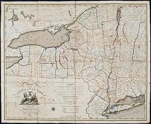
Map of the State of New York by Simeon De Witt Surveyor General Contracted from his large Map of the State
Publicado por New York, 1812
Librería: Donald A. Heald Rare Books (ABAA), New York, NY, Estados Unidos de America
Miembro de asociación: ABAA ILAB
Valoración del vendedor:

Mapa
Engraved map, hand-coloured in outline, sectioned and linen-backed at a contemporary date. Housed in a black morocco backed box. Unique copy of De Witt's important 1804 map of New York, with county divisions updated to 1812. In 1778, George Washington appointed Simeon De Witt as the assistant to Robert Erskine, the first Geographer and Surveyor General of the United States, a position De Witt attained several years later. Following the war, De Witt became the first Surveyor General of New York, a position he held for an unprecedented fifty years. Among his first acts was to create the definitive first map of the state based on actual surveys. Following the settlement of the state's boundaries and accurate surveys which he directed, De Witt published a large wall map in 1802 - the first map of the state and the progenitor of similar mappings in other states. Two years later, De Witt issued this "contracted" version of his wall map, intending its circulation to meet a wider audience. According to Allen, however, the map, which was sold by subscription, "does not seem to have been as widely distributed as its predecessor, although it appears to have been designed to reach a wider audience. It may be that De Witt's 1804 map was unable to find a niche in competition with other small-scale maps of the state, such as those of Samuel Lewis" (Allen). Nevertheless, as Streeter commented, De Witt's 1804 map is "one of the earliest separate folding maps of New York after it became a state." Interestingly, the present copy suggests that De Witt, or an enterprising mapseller, made an additional attempt to market this map. This copy of the 1804 map is updated to 1812; that is, the map is as printed in 1804 but the county boundaries shown via period hand colouring depicts the state in 1812: the far western counties established in 1808 are clearly delineated (e.g. Chautauqua, Cattaraugus, and Niagara counties) but Erie County created in 1821 is not shown; Putnam county is shown separate from Dutchess County as per its establishment in 1812; Oneida County is shown with its western boundary on Lake Ontario, i.e. before the 1816 establishment of Oswego County; among other additions. In all the state is divided into 47 counties. We find no other example of De Witt's 1804 map altered in this fashion. The exactness and appearance of the colouring, however, suggests it to be a distinct issue of the map, or done for some official purpose, as opposed to an early owner's mere manuscript addition. Ristow, American Maps and Mapmakers, pp. 73-83; Rumsey 2489; Streeter Sale 893; David Y. Allen, How Simeon De Witt Mapped New York State.