Importe total (1 artículo artículos):
Destino del pedido:

DE L'ISLE, GUILLAUME 1675 1726 (81 resultados)
Ir a los resultados principales
Tipo de artículo
- Todo tipo de artículos
- Libros (40)
- Revistas y publicaciones
- Cómics
- Partituras
- Arte, grabados y pósters (4)
- Fotografías
- Mapas (37)
-
Manuscritos y
coleccionismo de papel
Condición
- Todo
- Nuevos
- Antiguos o usados
Encuadernación
- Todo
- Tapa dura (5)
- Tapa blanda
Más atributos
- Primera edición (9)
- Firmado (1)
- Sobrecubierta
- Con imágenes del vendedor (65)
- Sin impresión bajo demanda
Ubicación del vendedor
Valoración de los vendedores
-
Rhein/Main/Mosel, anno 1704, Karte De L ` Isle
Publicado por De L`Isle, Guillaume, 1675-1726, 1726
Librería: Hammelburger Antiquariat, Hammelburg, Alemania
Valoración del vendedor:

Hardcover. Condición: very good. Rhein/Main/Mosel, anno 1704, Karte De L ` Isle. Großformatike Karte, verlegt in Paris, anno 1704, weitere Infos, siehe unten. Publisher: DE L'ISLE, G. Title: Le Cours du Rhin depuis Worms, jusqua Bonne, et Les Paysa Adjaces. Published in: Paris, 1704 Size: 20.7 x 29.0 inches. 52.7 x 73.7 cm. Map of the eastern Germany, showing the region surrounding the Rhine Rivers, or the Rhine Valley. Cities shown (from north to south) include Bonne, Cologne, Mainz, Frankfort and Worms.
-
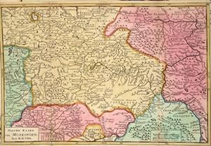
Nieuwe Kaart van Muskovien .
Publicado por Artist: L Isle de /Covens & Mortier Guillaume ( - 1726 ) Paris ; issued in: Paris ; ca: 1720; - Guillaume De L isle (1675- 1726) Paris was a French cartographer known for his popular and accurate maps of Europe and the newly explored Americas and Africa De L isle was admitted into the French Académie Royale des Sciences an institution financed by the French state After that date he signed his maps with the title of ?Géographe de l?Académie? Five years later he moved to the Quai de l?Horloge in Paris a true publishing hub where his business prospered De L isle?s ascension through the ranks culminated in 1718 when he received the title of Premier Géographe du Roi His new office consisted in teaching geography to the Dauphin King Louis XIV?s s, 1675
Librería: Antique Sommer& Sapunaru KG, München, Alemania
Miembro de asociación: ILAB VDA
Valoración del vendedor:
Technic: Copper print; colorit: original colored; condition: Very good, size (in cm): 17,5 x 26; - map shows the area around Moscow.
-
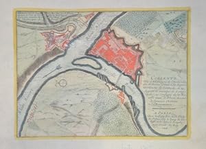
Coblentz
Publicado por Artist: L Isle de /Covens & Mortier Guillaume ( - 1726 ) Paris ; issued in: Paris ; dated: 1705; - Guillaume De L isle (1675- 1726) Paris was a French cartographer known for his popular and accurate maps of Europe and the newly explored Americas and Africa De L isle was admitted into the French Académie Royale des Sciences an institution financed by the French state After that date he signed his maps with the title of ?Géographe de l?Académie? Five years later he moved to the Quai de l?Horloge in Paris a true publishing hub where his business prospered De L isle?s ascension through the ranks culminated in 1718 when he received the title of Premier Géographe du Roi His new office consisted in teaching geography to the Dauphin King Louis XIV?, 1675
Librería: Antique Sommer& Sapunaru KG, München, Alemania
Miembro de asociación: ILAB VDA
Valoración del vendedor:
Technic: Copper print; colorit: original colored; condition: Very good, size (in cm): 19,5 x 26; - Map shows the city map of Coblenz with the rivers Rhein and Mosel and the castle Ermanstein.
-
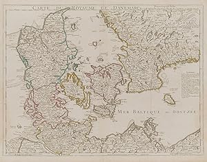
Carte du Royaume de Danemarc.
Publicado por Paris, De l'Isle et Buache., 1780
Librería: Inanna Rare Books Ltd., Skibbereen, CORK, Irlanda
Valoración del vendedor:

Arte / Grabado / Póster Ejemplar firmado
Original hand-coloured engraving. Plate Size: 64.4 cm x 48.7 cm. Sheet Size: 66.6 cm x 52.7 cm. Original map. In very good condition with the slightest traces of browning only. A very detailed and interesting map of Denmark - the Jutland peninsula and the archipelago of islands such as Funen, Zealand and Bornholm- and the and southern Sweden. The Duchies of Brem and Meckelbourg and Pomeranie on the German coast can be seen in the lower part of the map. The cities of Hamburg, Copenhagen and Rostock are included on the map. Relief is depicted pictorially. The sand banks and shallows along the coasts are also depicted. Block of annotative French text lies within the Baltic Sea. Guillaume Delisle, (1675-1726), was a renowned mapmaker who led the reform of French cartography. A brother of the astronomer Joseph-Nicolas Delisle and a student of the astronomer Jean-Dominique Cassini, Delisle learned to fix accurate positions by astronomical observation. The accuracy of his continental outlines and his reduction of gross errors in determining lines of longitude were considerable improvements over earlier maps. His earliest works, published in 1700, were a pair of globes (terrestrial and celestial), maps of the continents, and a world map in hemispheres. He prepared about 100 maps and wrote on mensuration and ancient geography. At 27, Delisle was admitted into the French Académie Royale des Sciences, an institution financed by the French state. After that date, he signed his maps with the title of "Géographe de l'Académie". Five years later, he moved to the Quai de l'Horloge in Paris, a true publishing hub where his business prospered. In 1718 he was the first to become chief geographer to the king. (Encylopedia Britannica).
-

The Seat of War on the Rhine being a New Map of the course of that River from Strasbourg to Bonn with the Adjacent countries.
Publicado por Thomas Bowles c.1725, London, 1725
Librería: Alexandre Antique Prints, Maps & Books, Toronto, ON, Canada
Miembro de asociación: ABAC ILAB
Valoración del vendedor:

Mapa
Condición: Very Good. Map showing the course of the Rhine river in Germany in two sheets.This map appeared in Moll's The world described, [1709-1736], plate 22., Size : 948x590 (mm), 37.32x23.23 (Inches), Original Outline Coloring.
-
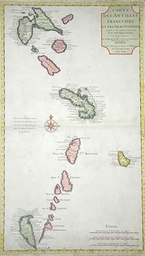
Carte des Antilles Francoises et des Isles Voisines.
Publicado por Artist: L Isle de /Covens & Mortier Guillaume ( - 1726 ) Paris ; issued in: Paris ; dated: 1717; - Guillaume De L isle (1675- 1726) Paris was a French cartographer known for his popular and accurate maps of Europe and the newly explored Americas and Africa De L isle was admitted into the French Académie Royale des Sciences an institution financed by the French state After that date he signed his maps with the title of ?Géographe de l?Académie? Five years later he moved to the Quai de l?Horloge in Paris a true publishing hub where his business prospered De L isle?s ascension through the ranks culminated in 1718 when he received the title of Premier Géographe du Roi His new office consisted in teaching geography to the Dauphin King Louis XIV?, 1675
Librería: Antique Sommer& Sapunaru KG, München, Alemania
Miembro de asociación: ILAB VDA
Valoración del vendedor:
Technic: Copper print; colorit: colored; condition: Very good, size (in cm): 65 x 38; - Map of the Lower Antilles, from Guadeloupe to Grenada.
-
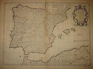
L'Espagne dressée sur la description qui en a été faite par Rodrigo Mendez Sylva.
Publicado por Parigi 1720 ca., 1720
Librería: Libreria Ex Libris ALAI-ILAB/LILA member, Roma, Italia
Miembro de asociación: ALAI ILAB
Valoración del vendedor:
Mapa
Incisione originale su rame (cm. 62x45 piů ampi margini). Coloritura coeva all'acquerello dei confini. Ottimo esemplare.
-
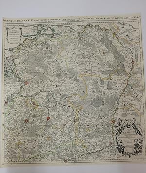
Ducatus Brabantiae. Complectens dominio lovanii, Bruxellarum, Antverpiae, Silvae ducis, mechliniae. Ad ufum serenisfimi brugundiae ducis.
Publicado por 0
Libro
Dimension : 67,3 x 64,5 cm. Carte du Brabant. Dressée sur plusieurs cartes particuličres manuscrites ou imprimées levées sur les lieux. Rectifiées par quelques observation et autre mémoire par Guillaume de l'Isle de l'académie royale des sciences. A Amsterdam, chez Jean Covens et Corneille Mortier. Carte en trčs bon état, redéposée sur Japon et nettoyée. Carte de 1730, issu du travail de carthographe de Guillaume Delisle (1675-1726), célčbre carthographe et géographe français. Français Pendant prčs de deux sičcles, la plus grande et la plus importante maison d'édition néerlandaise dans le domaine de la cartographie commerciale a été la société Covens & Mortier d'Amsterdam. En termes de quantité, c'était peut-ętre męme la plus grande maison de commerce de cartes contemporaine au monde. Elle distribuait d'innombrables cartes, atlas, globes et livres. Pieter (Pierre) Mortier (Leyde, 1661 - Amsterdam, 1711) On ne sait rien de la jeunesse de Pieter Mortier. Il a étudié ŕ Paris de 1681 ŕ 1685 environ. Lŕ, il a dű entrer en contact avec des libraires français et apprendre le métier de libraire. Début 1685, il est retourné ŕ Amsterdam oů il a ouvert une petite librairie. La męme année, il devient membre du guide des libraires, vendeurs d'art et imprimeurs. Pieter vendait des livres en néerlandais et en langues étrangčres, mais il publiait également des livres ŕ compte d'auteur, généralement en langue française. Ses affaires sont si florissantes qu'en 1688, il est déjŕ contraint de louer une autre maison sur la Vijgendam. Le premier privilčge de Pieter Mortier pour les cartes est accordé par les États de Hollande et de Frise occidentale le 15 septembre 1690. Il fait référence aux cartes de Sanson qu'il "imprime et corrige avec beaucoup de peine et de soin". Pieter a commencé la publication ŕ grande échelle de cartes et d'atlas. Au début du 18e sičcle, Pieter est devenu si riche qu'il peut acheter trois maisons ŕ Amsterdam : sur le Beurssluis, sur le Vijgendam et sur le Heremietensteeg. Il a reconstruit la maison sur le Vijgendam en une grande maison prestigieuse qui servira pendant plus d'un sičcle de boutique, de commerce et de structure résidentielle pour la maison d'édition de Covens & Mortier. Il meurt le 13 février 1711, aprčs une brčve maladie. La société a continué ŕ exister sous la direction de la veuve de Pieter, Amelia' s-Gravesande. Aprčs sa mort en 1719, son fils Cornelis a repris la direction pendant quelques années. Le 20 novembre 1721, une société est fondée par Cornelis Mortier et Johannes Covens I. Ce dernier se marie la męme année avec la s?ur de Cornelis. A partir de cette année-lŕ, le nom de : Covens & Mortier.
-
Tartarie carte de, map, L isle, anno 1706
Publicado por De L`Isle, Guillaume, 1675-1726, 1726
Librería: Hammelburger Antiquariat, Hammelburg, Alemania
Valoración del vendedor:
Hardcover. Condición: very good. Coppermap, edited anno 1706, L isle G., size of the leaf: 54x76 cm., on left and right margins little waterstained. Engraved map in outline colours.
-
Partie meridionale du Piemont et du Monferrat
Publicado por Paris, 1720 circa, 1720
Librería: TABERNA LIBRARIA - ALAI - ILAB, Pistoia, Italia
Miembro de asociación: ALAI ILAB
Valoración del vendedor:
Inc. su rame impreziosita da coloritura ottocentesca, mm. 500x648 alla battuta su foglio di mm. 510x710, rifilata alla battuta del marg. sup. Piegata centralmente all'origine.
-
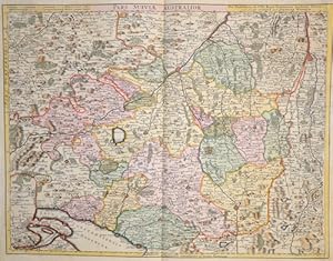
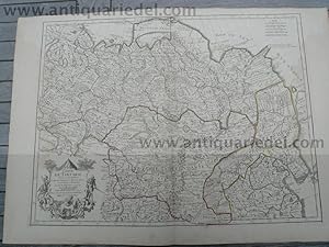
Pars Sueviae Australior
Publicado por Artist: L Isle de /Covens & Mortier Guillaume ( - 1726 ) Paris ; issued in: Paris ; ca: 1730; - Guillaume De L isle (1675- 1726) Paris was a French cartographer known for his popular and accurate maps of Europe and the newly explored Americas and Africa De L isle was admitted into the French Académie Royale des Sciences an institution financed by the French state After that date he signed his maps with the title of ?Géographe de l?Académie? Five years later he moved to the Quai de l?Horloge in Paris a true publishing hub where his business prospered De L isle?s ascension through the ranks culminated in 1718 when he received the title of Premier Géographe du Roi His new office consisted in teaching geography to the Dauphin King Louis XIV?s s, 1675
Librería: Antique Sommer& Sapunaru KG, München, Alemania
Miembro de asociación: ILAB VDA
Valoración del vendedor:
Technic: Copper print; colorit: colored; condition: Right margin replaced, size (in cm): 48 x 61 cm; - Magnificent map showing the whole of Swabia with the cities of Augsburg, Ulm, Memmingen, Kempten, Nördlingen, Lindau on Lake Constance, and many more; Baden-Württemberg with Constance, Tübingen, Stuttgart, Heidelberg, Pforzheim, Freiburg im Breisgau,.
-

Atlante novissimo del Sig.
Publicado por Artist: L Isle de/ Albizzi G Guillaume ( - 1726 ) Paris ; issued in: Venice ; ca: 1750; - Guillaume De L isle (1675- 1726) Paris was a French cartographer known for his popular and accurate maps of Europe and the newly explored Americas and Africa De L isle was admitted into the French Académie Royale des Sciences an institution financed by the French state After that date he signed his maps with the title of ?Géographe de l?Académie? Five years later he moved to the Quai de l?Horloge in Paris a true publishing hub where his business prospered De L isle?s ascension through the ranks culminated in 1718 when he received the title of Premier Géographe du Roi His new office consisted in teaching geography to the Dauphin King Louis XIV?s son a t, 1675
Librería: Antique Sommer& Sapunaru KG, München, Alemania
Miembro de asociación: ILAB VDA
Valoración del vendedor:
Arte / Grabado / Póster
Technic: Copper print; colorit: original colored; condition: Very good, size (in cm): 29 x 20; - Titlepage showing male and female soldiers ans a view of St Mark's Square and the canals of Venice,; - Special feature: From "Atlante Novissimo Che Contiene Tutte Le Parti Del Mondo .".
-
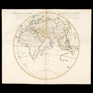
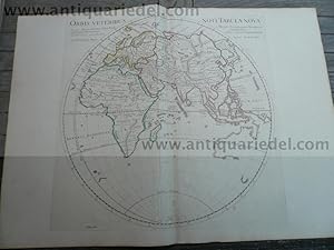
Orbis veteribus noti tabula nova
Librería: Douglas Stewart Fine Books, Armadale, VIC, Australia
Miembro de asociación: ANZAAB ILAB
Valoración del vendedor:
Auctore Guillelmo Del'Isle e Regia Scientiarum Academia et Christianissimi Francorum Regis Geographo primario.Amstelodami : apud I Covens et C. Mortier, [circa 1741]. Copperplate engraving on paper, 46.4 cm. in diameter, on sheet 53.5 x 65.5 cm, coloured by hand, central fold as issued, small paper reinforcement verso, lightly marked, a fine example. An impressive, large scale map of the Eastern hemisphere, the continent of New Holland showing the Dutch discoveries.
-
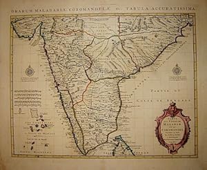
Carte des cotes de Malabar et de Coromandel.
Publicado por Amsterdam, 1742
Librería: Libreria Ex Libris ALAI-ILAB/LILA member, Roma, Italia
Miembro de asociación: ALAI ILAB
Valoración del vendedor:
Mapa
carta geografica originale (cm. 56x43,2 piů ampi margini bianchi). Coloritura antica all'acquarello. Un piccolo restauro nella parte centrale al margine superiore, altrimenti ottimo esemplare.
-
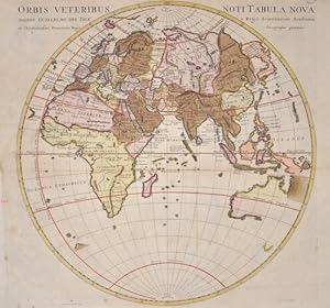
Orbis Veteribus Noti Tabula Nova
Publicado por Artist: L Isle de /Covens & Mortier Guillaume ( - 1726 ) Paris ; issued in: Paris ; ca: 1720; - Guillaume De L isle (1675- 1726) Paris was a French cartographer known for his popular and accurate maps of Europe and the newly explored Americas and Africa De L isle was admitted into the French Académie Royale des Sciences an institution financed by the French state After that date he signed his maps with the title of ?Géographe de l?Académie? Five years later he moved to the Quai de l?Horloge in Paris a true publishing hub where his business prospered De L isle?s ascension through the ranks culminated in 1718 when he received the title of Premier Géographe du Roi His new office consisted in teaching geography to the Dauphin King Louis XIV?s s, 1675
Librería: Antique Sommer& Sapunaru KG, München, Alemania
Miembro de asociación: ILAB VDA
Valoración del vendedor:
Technic: Copper print; colorit: original colored; condition: Some folds perfectly restored, size (in cm): 38 x 38; - Map shows the old World in a Hemisphere.
-

In notitiam Ecclesiasticam Africae, Tabula geographica
Publicado por Parigi 1720 ca., 1720
Librería: Libreria Ex Libris ALAI-ILAB/LILA member, Roma, Italia
Miembro de asociación: ALAI ILAB
Valoración del vendedor:
Mapa
Incisione originale su rame (cm. 64,5x49 piů margini). Coloritura coeva all'acquarello dei confini. Ottimo esemplare.
-

Carte de l'Egypte, de la Nubie, de l'Abissinie.
Publicado por Parigi 1720 ca., 1720
Librería: Libreria Ex Libris ALAI-ILAB/LILA member, Roma, Italia
Miembro de asociación: ALAI ILAB
Valoración del vendedor:
Mapa
Incisione originale su rame (cm. 61x49 piů margini). Coloritura coeva all'acquarello dei confini. Buon esemplare.
-
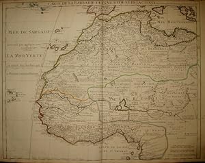
Carte de la Barbarie, de la Nigritie et de la Guinée.
Publicado por Parigi, 1707
Librería: Libreria Ex Libris ALAI-ILAB/LILA member, Roma, Italia
Miembro de asociación: ALAI ILAB
Valoración del vendedor:
Mapa
Incisione originale su rame (cm. 61x48 piů margini). Carta vergellata con filigrana. Coloritura coeva all'acquarello dei confini. Ottimo esemplare.
-
Carte de L'Isle de la Martinique Colonie Françoise de l'une des Isles Antilles de l'Amerique Dressée sur des Plans manuscrits entr' autres sur celui de Mr. Mouel Ingenieur du Roy Assujetis ŕ des Observations Astronomiques et conciliés avec des memoires particuliers de feu Mr Guill. Delisle Premier Geographe de S. Majesté.
Publicado por Covens and Mortier, Amsterdam, 1757
Librería: Donald A. Heald Rare Books (ABAA), New York, NY, Estados Unidos de America
Miembro de asociación: ABAA ILAB
Valoración del vendedor:
Mapa
Engraved with early outline colour. Printed on laid paper. In perfect condition. Image size: 18 1/8 x 23 1/8 inches. A handsome 18th-century topographical map of Martinique. This highly detailed map of Martinique delineates the hilly terrain, forests, roads, houses, and even the sugar plantations. The island was to the French what Barbados and Jamaica were to the English: immensely profitable sites for sugar production. Guillaume de l'Isle (1675-1726) was the son of a cartographer and a pupil of Jean Dominique Cassini, who, among other important contributions, aligned the study of astronomy to the study of geography. Under Cassini's direction, observations were made from locations all over the world that enabled longitudinal calculations to be made with much greater accuracy. De l'Isle carried on this exacting work with remarkable dedication and integrity, constantly revising and improving his maps. While precision was his primary goal, his maps are invariably elegant and attractive. Jean (Johannes) Covens and Corneille (Cornelius) Mortier were brothers-in-law, who carried on the book publishing business established by Pierre Mortier in Amsterdam in 1685. Pierre Mortier's company owed much of its success to his access to French publishers, whose publications he re-issued in handsome editions.The elder Mortier died in 1711; his wife continued the firm until she died in 1719. In 1721, Covens and Mortier formed a partnership, Covens having married Agatha Mortier in the same year. They continued the business by publishing enlarged editions of Sanson, Jaillot, and De L'Isle, as well as some of the later Dutch cartographical masters such as De Wit and Allard, and of course Pierre Mortier. Koeman, C & M 8 #118.
-

Carte de la Barbarie le la Nigritie et de la Guinée
Publicado por Artist: L Isle de /Covens & Mortier Guillaume ( - 1726 ) Paris ; issued in: Paris ; ca: 1720; - Guillaume De L isle (1675- 1726) Paris was a French cartographer known for his popular and accurate maps of Europe and the newly explored Americas and Africa De L isle was admitted into the French Académie Royale des Sciences an institution financed by the French state After that date he signed his maps with the title of ?Géographe de l?Académie? Five years later he moved to the Quai de l?Horloge in Paris a true publishing hub where his business prospered De L isle?s ascension through the ranks culminated in 1718 when he received the title of Premier Géographe du Roi His new office consisted in teaching geography to the Dauphin King Louis XIV?s s, 1675
Librería: Antique Sommer& Sapunaru KG, München, Alemania
Miembro de asociación: ILAB VDA
Valoración del vendedor:
Technic: Copper print; colorit: original colored; condition: Left and right lower corners replaced, size (in cm): 50 x 48 cm; - Map shows the western coast of Africa.
-

In Notitiam Ecclesiasticam Africae Tabula Geographica
Publicado por Artist: L Isle de /Covens & Mortier Guillaume ( - 1726 ) Paris ; issued in: Paris ; dated: 1700; - Guillaume De L isle (1675- 1726) Paris was a French cartographer known for his popular and accurate maps of Europe and the newly explored Americas and Africa De L isle was admitted into the French Académie Royale des Sciences an institution financed by the French state After that date he signed his maps with the title of ?Géographe de l?Académie? Five years later he moved to the Quai de l?Horloge in Paris a true publishing hub where his business prospered De L isle?s ascension through the ranks culminated in 1718 when he received the title of Premier Géographe du Roi His new office consisted in teaching geography to the Dauphin King Louis XIV?, 1675
Librería: Antique Sommer& Sapunaru KG, München, Alemania
Miembro de asociación: ILAB VDA
Valoración del vendedor:
Technic: Copper print; colorit: original colored; condition: Very good, size (in cm): 48 x 64 cm; - Map shows Marocco, Algeria and Tunesia with Spain, Balear Islands, Corsica, Sardinia and Sicily.; - Special feature: 3 beautiful cartouches.
-
Orbis Veteribus with Australia, map, anno 1720
Publicado por De L`Isle, Guillaume, 1675-1726, 1726
Librería: Hammelburger Antiquariat, Hammelburg, Alemania
Valoración del vendedor:
Hardcover. Condición: very good. Worldmap with Australia, edited circa anno 1720, size of the leaf: 55x76 cm., for more infos please klick the below link.
-
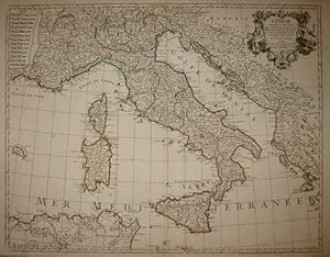
L'Italie dressée sur les Observations de M.rs de l'Académie Royale des Sciences.
Publicado por Parigi, 1788
Librería: Libreria Ex Libris ALAI-ILAB/LILA member, Roma, Italia
Miembro de asociación: ALAI ILAB
Valoración del vendedor:
Mapa
Carta geografica originale (cm. 64x49,5 piů margini). Coloritura coeva dei confini. Ottimo esemplare. Borri, 150.
-
Carte du Paraguay du Chili
Publicado por Artist: L Isle de /Covens & Mortier Guillaume ( - 1726 ) Paris ; issued in: Paris ; dated: 1703; - Guillaume De L isle (1675- 1726) Paris was a French cartographer known for his popular and accurate maps of Europe and the newly explored Americas and Africa De L isle was admitted into the French Académie Royale des Sciences an institution financed by the French state After that date he signed his maps with the title of ?Géographe de l?Académie? Five years later he moved to the Quai de l?Horloge in Paris a true publishing hub where his business prospered De L isle?s ascension through the ranks culminated in 1718 when he received the title of Premier Géographe du Roi His new office consisted in teaching geography to the Dauphin King Louis XIV?, 1675
Librería: Antique Sommer& Sapunaru KG, München, Alemania
Miembro de asociación: ILAB VDA
Valoración del vendedor:
Technic: Copper print; colorit: original colored; condition: Very good, size (in cm): 50 x 65; - Map of the southern part of South America.
-
L'Afrique, Dressee sur les Observationsde Mrs de l'Academie Royale des Sciences, et quelques autres, & sur les Memoires les plus récens Par G. de l'Isle, .
Publicado por Paris, 1700
Librería: Alexandre Antique Prints, Maps & Books, Toronto, ON, Canada
Miembro de asociación: ABAC ILAB
Valoración del vendedor:
Mapa
Condición: Very Good. Large and decorative map of Africa in original hand colouring., Size : 453x586 (mm), 17.83x23.07 (Inches), Original Hand Coloring.
-
L'Amerique Meridionale Dressee sur les Observations de Mrs de l'Academie Royale des Sciences,.
Publicado por Paris, 1700
Librería: Alexandre Antique Prints, Maps & Books, Toronto, ON, Canada
Miembro de asociación: ABAC ILAB
Valoración del vendedor:
Mapa
Condición: Very Good. Large and decorative map of South America in original hand colouring., Size : 466x613 (mm), 18.35x24.13 (Inches), Original Hand Coloring.
-
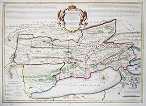
Carte de la Souveraineté de Neuchâtel et Vallangin, dressée sur les Mémoires du Sr. D. F. de Merveilleux. Rectifié par les Observations de l?Academie Royale des Sciences.
Publicado por entre 1700 - 1730,, 1730
Librería: Harteveld Rare Books Ltd., Fribourg, Suiza
Miembro de asociación: ILAB VEBUKU
Valoración del vendedor:
49 x 64 cm, carte gravée coloriée ŕ la main, pli central, papier frais, qqs rares taches en bas de la carte, 1 feuille (53 x 67.5 cm). Carte publiée dans: Guillaume de Lisle, Atlas nouveau, contenant toutes les parties Du Monde, oů sont exactement remarqués les empires, monarchies, royaumes, états, républiques, &c. Premier géographe de sa Majesté, Amsterdam, Chez Jean Covens & Corneille Mortier.Please notify before visiting to see a book. Prices are excl. VAT/TVA (only Switzerland) & postage. Ryhiner 6355; Froidevaux, Bibliographie neuchâteloise, 323.
-
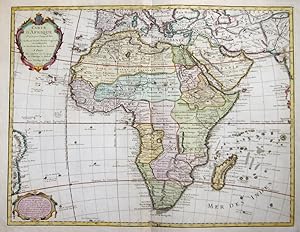
Carte d' Afrique Dressee pour l'usage du Roy
Publicado por Artist: L Isle de /Covens & Mortier Guillaume ( - 1726 ) Paris ; issued in: Paris ; dated: 1722; - Guillaume De L isle (1675- 1726) Paris was a French cartographer known for his popular and accurate maps of Europe and the newly explored Americas and Africa De L isle was admitted into the French Académie Royale des Sciences an institution financed by the French state After that date he signed his maps with the title of ?Géographe de l?Académie? Five years later he moved to the Quai de l?Horloge in Paris a true publishing hub where his business prospered De L isle?s ascension through the ranks culminated in 1718 when he received the title of Premier Géographe du Roi His new office consisted in teaching geography to the Dauphin King Louis XIV?, 1675
Librería: Antique Sommer& Sapunaru KG, München, Alemania
Miembro de asociación: ILAB VDA
Valoración del vendedor:
Technic: Copper print; colorit: original colored; condition: Restoration at lower centerfold, size (in cm): 49 x 64; - Carte d Afrique- Map shows the continent of Africa with its countries and their borders in 1720. Paper shows a watermark on the left side.
-
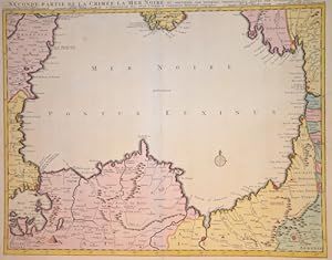
Seconde Partie de la Crimee La Mer Noir
Publicado por Artist: L Isle de /Covens & Mortier Guillaume ( - 1726 ) Paris ; issued in: Paris ; ca: 1720; - Guillaume De L isle (1675- 1726) Paris was a French cartographer known for his popular and accurate maps of Europe and the newly explored Americas and Africa De L isle was admitted into the French Académie Royale des Sciences an institution financed by the French state After that date he signed his maps with the title of ?Géographe de l?Académie? Five years later he moved to the Quai de l?Horloge in Paris a true publishing hub where his business prospered De L isle?s ascension through the ranks culminated in 1718 when he received the title of Premier Géographe du Roi His new office consisted in teaching geography to the Dauphin King Louis XIV?s s, 1675
Librería: Antique Sommer& Sapunaru KG, München, Alemania
Miembro de asociación: ILAB VDA
Valoración del vendedor:
Technic: Copper print; colorit: original colored; condition: Very good, size (in cm): 50 x 61; - Map shows the total balck sean and its neighbour countries.
-
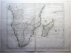
Carte du Congo et du Pays des Cafres .
Publicado por Philippe Buache, Paris, 1780
Librería: Angelika C. J. Friebe Ltd. - MapWoman, Dorking, Reino Unido
Miembro de asociación: ABA ILAB
Valoración del vendedor:
Mapa
No Binding. Condición: Very Good. copper engraved map with old outline colouring; plate 49 x 63 cm. fold as issued; paper evenly toned; 1 some discoluration, staining and faint foxing; ; o/w vg cond. Watermarked.- A large and detailed map of South Africa. With privilege and Buache s signature.- De l Isle was a French cartographer and pupil of Cassini. He was one of the most important and influential French mapmakers of the early 18th century.