Importe total (1 artículo artículos):
Destino del pedido:

CENTRAL AMERICA MAP (6 resultados)
Ir a los resultados principales
Tipo de artículo
- Todo tipo de artículos
- Libros (3)
- Revistas y publicaciones
- Cómics
- Partituras
- Arte, grabados y pósters
- Fotografías
- Mapas (3)
-
Manuscritos y
coleccionismo de papel
Condición
- Todo
- Nuevos
- Antiguos o usados
Encuadernación
- Todo
- Tapa dura
- Tapa blanda (1)
Más atributos
- Primera edición (1)
- Firmado
- Sobrecubierta
- Con imágenes del vendedor (4)
- Sin impresión bajo demanda
Ubicación del vendedor
Valoración de los vendedores
-

Central America - South America and Mexico - an Antique Map
Librería: K Books Ltd ABA ILAB, York, YORKS, Reino Unido
Miembro de asociación: ABA ILAB PBFA
Valoración del vendedor:

Libro
No Binding. Condición: Very Good. Engraved By Walker Ilustrador. A fine antique map - printed in 1844. Mounted (matted) and ready to frame. Engraved Size 12 x 10 Ins, 30 x 26 Cms. Mounted size approx 15 x 13 ins, 38 x 33cms. Coloured in outline, hand colouring contemporary. A fine opportunity to purchase an attractive and decorative engraved antique map of Central America - South America and Mexico.
-
Map of Central America and the West Indies - Fine Detailed Map - an Original Engraving
Ańo de publicación: 1860
Librería: K Books Ltd ABA ILAB, York, YORKS, Reino Unido
Miembro de asociación: ABA ILAB PBFA
Valoración del vendedor:
Libro
No Binding. Condición: Very Good. A fine engraving - printed circa 1860. Mounted and ready to frame. Hand colouring not contemporary, but delicately and expertly executed. A fine opportunity to purchase an attractive and decorative engraving - Map of Central America and the West Indies.
-
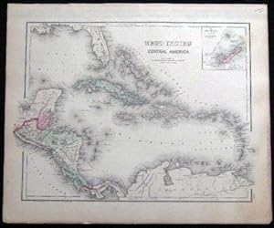
Original Hand-Colored Map of South America (and) Map of the West Indies and Central America with Inset of the Bermuda Islands
Publicado por O.W. Gray & Son, Philadelphia, PA, 1882
Librería: Certain Books, ABAA, Bolivia, NC, Estados Unidos de America
Miembro de asociación: ABAA ESA ILAB
Valoración del vendedor:

Original o primera edición
Not Bound. Condición: Very Good. Map. One sheet, printed with 2 maps, from the 1882 O.W. Gray National Atlas, New York Edition: South America (and) West Indies and Central America & inset of The Bermuda Islands. With hand-coloring in pastel tones and red border outlining. Approx. 14 3/8" x 17 1/4" overall size; a little even toning to the paper, margins with some spotting; couple of small nicks at edges, corners; in very good condition.
-
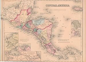
Central America
Publicado por J.H. Colton & Co, New York, 1855
Librería: Main Street Fine Books & Mss, ABAA, Galena, IL, Estados Unidos de America
Miembro de asociación: ABAA ILAB MWABA
Valoración del vendedor:
Mapa
16˝" X 13˝" (image 15" X 11 3/4"). Hand colored. Very good. Mild age toning; minor discoloration along edges (not touching image). Nicely colored example, featuring three insets at lower left showing "Isthmus of Panama," "Harbor of San Juan de Nicaragua" and "The 'Nicaragua Route'" and two at center right showing "Aspinwall City" and "City of Panama.".
-
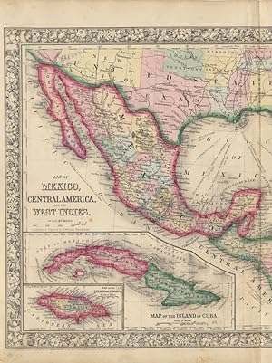
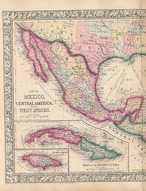
Map of Mexico, Central America, and the West Indies
Publicado por S. Augustus Mitchell, Jr., New York, 1860
Librería: Main Street Fine Books & Mss, ABAA, Galena, IL, Estados Unidos de America
Miembro de asociación: ABAA ILAB MWABA
Valoración del vendedor:
Mapa
Folio (23˝" X 15Ľ", image area 21Ľ" X 13Ľ"). Hand colored. Very good. Some age toning and minor soiling (mainly about edges), with single small inoffensive stain and single vertical fold (as issued). Wonderfully colored centerfold map of this large region, from the 1864 edition of "Mitchell's New General Atlas, Containing Maps of the Various Countries of the World, Plans of Cities, Etc." Two insets at upper right show "Map of the Bermuda Islands" and "Map of the Panama Railroad," while another pair at lower left show "Map of the Island of Cuba" and "Map of the Island of Jamaica." Much of the southern U.S. is visible as well: Part of California and New Mexico, all of Texas, Louisiana, Mississippi, Alabama, Georgia, Florida, Arkansas, Tennessee, both Carolinas and more partial states. Nicely colored, with sharp floral border.
-
Map of Mexico, Central America, and the West Indies
Publicado por S. Augustus Mitchell, Jr., New York, 1860
Librería: Main Street Fine Books & Mss, ABAA, Galena, IL, Estados Unidos de America
Miembro de asociación: ABAA ILAB MWABA
Valoración del vendedor:
Mapa
Folio (23˝" X 15Ľ", image area 21Ľ" X 13Ľ"). Hand colored. Very good. Lightly age toned, with single vertical fold (as issued). Bright and fetching centerfold map of this large region, from the 1864 edition of "Mitchell's New General Atlas, Containing Maps of the Various Countries of the World, Plans of Cities, Etc." Two insets at upper right show "Map of the Bermuda Islands" and "Map of the Panama Railroad," while another pair at lower left show "Map of the Island of Cuba" and "Map of the Island of Jamaica." Much of the southern U.S. is visible as well: Part of California and New Mexico, all of Texas, Louisiana, Mississippi, Alabama, Georgia, Florida, Arkansas, Tennessee, both Carolinas and more partial states. Handsomely colored, with fine decorative border.