
Importe total (1 artículo artículos):
Destino del pedido:

BRAUN, GEORGE, & FRANZ HOGENBERG (17 resultados)
Ir a los resultados principales
Tipo de artículo
- Todo tipo de artículos
- Libros (11)
- Revistas y publicaciones
- Cómics
- Partituras
- Arte, grabados y pósters (6)
- Fotografías
- Mapas
-
Manuscritos y
coleccionismo de papel
Condición
Encuadernación
- Todo
- Tapa dura (6)
- Tapa blanda
Más atributos
- Primera edición (3)
- Firmado
- Sobrecubierta (1)
- Con imágenes del vendedor (14)
- Sin impresión bajo demanda
Ubicación del vendedor
Valoración de los vendedores
-

Alte deutsche Städtebilder
Publicado por J. Asmus Verlag 1964, 1968
Librería: Antiquariat Walter Nowak, Göttingen, Alemania
Valoración del vendedor:

geringe äußere Gebrauchsspuren. Gewicht in Gramm: 550.
-
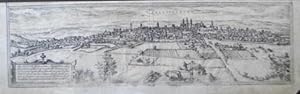
Vallisoletum.
Ańo de publicación: 1612
Librería: BOTTEGHINA D'ARTE GALLERIA KÚPROS, Rosignano Solvay, LI, Italia
Valoración del vendedor:

Arte / Grabado / Póster
No legatura. Condición: buono. Dal "Civitatus Orbis terrarum", 1612 circa. Incisione in rame all'acquaforte, b/n, cm 16 x 51,5 (il foglio) L'opera rappresenta uno dei libri piů importanti sui piani urbanistici divulgati nel corso del XVII secolo. La stampa (come spesso accade nelle vedute del Braun Hogenberg) prevede nella parte superiore un'altra veduta, la veduta di Toledo. Le troviamo in commercio spesso separate proprio perché trattasi di vedute distinte, con titoli separati. Impressione stanca nella parte inferiore e rifilato il margine superiore in prossimitŕ della lastra, discreta conservazione.
-
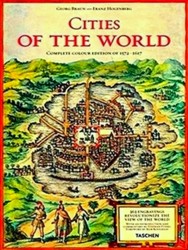
Cities of the World
Publicado por Taschen America, 2008
ISBN 10: 3822852724ISBN 13: 9783822852729
Libro Original o primera edición
Hardcover. Condición: New. First Edition. First Edition thus, as good as new. Cities of the World by George Braun; Franz Hogenberg. Published by Taschen America in 2008. Hardcover ISBN:9783822852729. Collectible item in excellent condition.
Más opciones de compra de otros vendedores en IberLibro
Nuevo desde EUR 149,00
Usado desde EUR 185,23
Encuentre también Tapa dura Original o primera edición
-
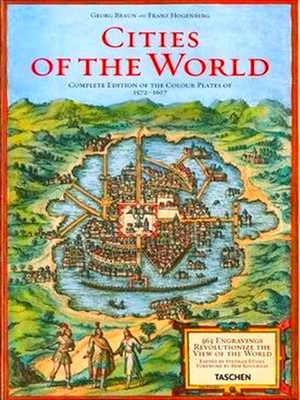
George Braun and Franz Hogenberg: Cities of the World: 363 Engravings Revolutionize the View of the World Complete Edition of the Colour Plates of 1572-1617
Publicado por Taschen America Llc, 2011
ISBN 10: 3836526859ISBN 13: 9783836526852
Libro Original o primera edición
Hardcover. Condición: New. First Edition. First Edition thus, as good as new. George Braun and Franz Hogenberg: Cities of the World: 363 Engravings Revolutionize the View of the World Complete Edition of the Colour Plates of 1572-1617 by George Braun; Franz Hogenberg. Published by Taschen America Llc in 2011. Hardcover ISBN:9783836526852. Collectible item in excellent condition.
Más opciones de compra de otros vendedores en IberLibro
Nuevo desde EUR 149,00
Usado desde EUR 323,65
Encuentre también Tapa dura Original o primera edición
-
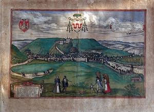
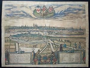
Huum Oppidum Condrusorum Caput.
Ańo de publicación: 1574
Librería: BOTTEGHINA D'ARTE GALLERIA KÚPROS, Rosignano Solvay, LI, Italia
Valoración del vendedor:
Arte / Grabado / Póster
No legatura. Condición: buono. Dal "Civitatus Orbis Terrarum", 1574. Incisione in rame all'acquaforte, colore d'epoca, cm 30,5 x 46,3 (alla lastra), piů margini. L'opera rappresenta uno dei libri piů importanti sui piani urbanistici divulgati nel corso del XVII secolo. Stemma in alto a sinistra, legenda a 10 voci in alto a destra, cartiglio esplicativo in basso sulla sinistra, che include l'anno di pubblicazione. I Condrusi erano una tribů germanica dell'antico Belgio. La regione geografica moderna di Condroz si pensa che corrisponda grosso modo alla zona dove i Condrusi vissero, Huum l'antico nome della cittŕ capitale. Foglio uniformemente e marcatamente ingiallito, rotture della carta sulla destra, a circa metŕ del margine laterale, bella la coloritura.
-
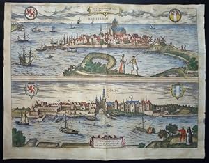
Rotterdam Hollandiae Opp. / Goude Hollandiae Opp.
Ańo de publicación: 1657
Librería: BOTTEGHINA D'ARTE GALLERIA KÚPROS, Rosignano Solvay, LI, Italia
Valoración del vendedor:
Arte / Grabado / Póster
No legatura. Condición: buono. Amsterdam, 1657 circa. Dal "Theatrum Praecipuarum Urbium" del Janssonius, pubblicata tra il 1652 ed il 1657, composta da circa 500 tavole raccolte in 8 volumi aventi tutti un titolo diverso. L opera si rifŕ al "Civitates Orbis Terrarum" di Braun & Hogenberg, uno dei libri piů importanti sui piani urbanistici divulgati nel corso del XVII secolo, le cui lastre furono acquistate dopo la morte di Abraham Hogenberg. Incisione in rame all'acquaforte, colore d'epoca, cm 37,2 x 48,5 circa (alla lastra), piů margini. Cartiglio in alto al centro in piccolo riquadro, velieri nel mare, testo latino al verso con grande capolettera che inizia la descrizione delle cittŕ di Rotterdam e di Gouda. Foglio uniformemente ingiallito con alcuni punti di ossidazione e una accentuazione della brachetta centrale con un piccolo difetto nella parte inferiore, altri difetti lungo il margine destro, piacevole coloritura, sano l inciso.
-
Traiectum ad Mosam.
Ańo de publicación: 1657
Librería: BOTTEGHINA D'ARTE GALLERIA KÚPROS, Rosignano Solvay, LI, Italia
Valoración del vendedor:
Arte / Grabado / Póster
No legatura. Condición: buono. Amsterdam, 1657 circa. Dal "Theatrum Praecipuarum Urbium" del Janssonius, pubblicata tra il 1652 ed il 1657, composta da circa 500 tavole raccolte in 8 volumi aventi tutti un titolo diverso. L opera si rifŕ al "Civitates Orbis Terrarum" di Braun & Hogenberg, uno dei libri piů importanti sui piani urbanistici divulgati nel corso del XVII secolo, le cui lastre furono acquistate dopo la morte di Abraham Hogenberg. Incisione in rame all'acquaforte, colore d'epoca, cm 37,2 x 49,8 circa (alla lastra), piů margini. Cartiglio in basso, sulla sinistra, legenda in basso, sulla destra, entro riquadri, figure e animali, testo latino al verso con grande capolettera che inizia la descrizione delle cittŕ di Traiectum ad Mosam. Mosa Traiectum, nota anche con la variante Trajectum, č il nome latino della cittŕ olandese di Maastricht e significa letteralmente "per attraversare la Mosa". A volte veniva indicata come Traiectum Superior, per distinguerla da Trajectum Inferior, l'attuale Utrecht, chiamata anche Traiectum ad Rhenum. Non č chiaro se il nome sia di origine romana. Sebbene probabilmente Maastricht non sia mai stata una cittŕ romana, molti scavi archeologici mostrano che la cittŕ č stata un insediamento significativo durante tutto il periodo della presenza romana nei paesi Bassi, e la cittŕ č infatti sede di punti di interesse storici, come ci si puň aspettare da un luogo risalente al periodo romano. Traiectum ad Mosam era un villaggio di medie dimensioni vicino al luogo in cui la strada principale era Tongeren (la capitale dei Tungri), e Colonia (la capitale degli Ubiani e della Germania Inferiore) e attraversava la Mosa. Nel IV secolo, la cittŕ, che fungeva da porto di Tongeren, fu pesantemente fortificata e questo castello divenne il nucleo della cittŕ medievale e moderna. Il municipium romano "traiectum ad Mosam" che risale al 50 a. C. si sviluppň con il cristianesimo sin dall'epoca tardo imperiale, fu sede vescovile dal 380 al 722 e il suo primo pastore fu San Servazio. Foglio uniformemente brunito, una rottura rimarginata nella parte destra (circa 10 cm) in vivace e bella coloritura, sano l'inciso.
-
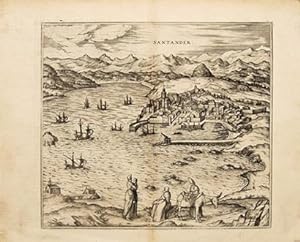
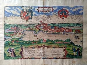
Santander.
Publicado por Civitates Orbis Terrarum. Cologne. c.1590, French edition, 1590
Librería: Peter Harrington. ABA/ ILAB., London, Reino Unido
Miembro de asociación: ABA ILAB PBFA
Valoración del vendedor:
Original o primera edición
Beautiful view of the Spanish city of Santander. Showing the port and harbour, ships in the bay, mountains beyond and three women, a donkey and a baby in the foreground. Braun and Hogenberg's Civitates Orbis Terrarum was a monumental work completed over 45 years between 1572 and 1617, and was one of the best-selling works of the late sixteenth-century. It was the first systematic city atlas (containing the first printed views of many towns). Ortelius, who travelled with the artist Joris Hoefnagel supplied much of the material, which was then engraved by Novellus and Hogenburg. George Braun wrote the text. There were a number of editions, but it is extremely difficult (and as Koeman says 'of secondary importance') to differentiate between them, as the state of the plates, their number and order does not vary. Copper engraving. Uncoloured. Some showthrough of text from verso on left margin.Very good condition, but very small hole in top border. Size: 355 x 320 mm. (14 x 12˝ inches).
-
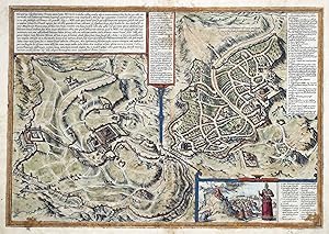
Hierosolyma, Clarissima totius Orientis ciuitas, Iudaee Metropolis.
Publicado por Cologne, 1572-. 342 x 487mm (13˝ x 19Ľ inches)., 1572
Librería: Tooley, Adams & Co., Wallingford, OXON, Reino Unido
Valoración del vendedor:
Original colour; some soiling and staining, other marginal spotting, toning and tears, particularly around the lower centrefold, one longer tear into plate mark has been repaired with old paper, probably done in the book, priced accordingly. From the first volume of Braun & Hogenberg's 'Civitates orbis terrarum'. Two plans of Jerusalem on one sheet, one an imaginary description of the ancient city of Jerusalem at the time of Christ, and the other a topographical description of the modern city. Moses receiving the tablets of the Law appears in a small inset at bottom right. LAOR: 1039.
-

Dordracum.
Ańo de publicación: 1584
Librería: BOTTEGHINA D'ARTE GALLERIA KÚPROS, Rosignano Solvay, LI, Italia
Valoración del vendedor:
Arte / Grabado / Póster
No legatura. Condición: buono. Dal "Civitatus Orbis Terrarum", Colonia (Köln), 1584 circa. Incisione in rame all'acquaforte, colore d'epoca, cm 31,5 x 49,5 (alla lastra), piů margini. Stemmi in alto a sinistra, figura protrettrice della cittŕ in alto al centro, entro recinto, con stemma e lancia piumata; cartiglio sulla destra, in alto; in basso legenda a 19 voci; testo latino al verso. L'opera rappresenta uno dei libri piů importanti sui piani urbanistici divulgati nel corso del XVII secolo e questa veduta la cittŕ di Dordrecht, nell'Olanda meridionale. Leggermente brunito ma buon esemplare in margini e in bella coloritura coeva.
-
Sclesuicum, Slesuigum / Gottorpia.
Ańo de publicación: 1584
Librería: BOTTEGHINA D'ARTE GALLERIA KÚPROS, Rosignano Solvay, LI, Italia
Valoración del vendedor:
Arte / Grabado / Póster
No legatura. Condición: buono. Dal "Civitatus Orbis Terrarum", Colonia (Köln), 1584. Incisione in rame all'acquaforte, colore d'epoca, cm 33,5 x 48,5 (alla lastra) piů margini, due grandi stemmi in alto, ai lati del titolo, cartiglio esplicativo in basso, al centro, che include l'anno di pubblicazione, testo latino al verso. L'opera rappresenta uno dei libri piů importanti sui piani urbanistici divulgati nel corso del XVII secolo e questa veduta la cittŕ di Schlewig e la vicina Gottorpia, all'epoca cittŕ della Danimarca ma oggi nella Germania nord orientale. View of Schleswig and it's neighbor Gottorpia, then in Denmark but now oriental northern Germany. Bell'esemplare in margini e in splendida coloritura coeva.
-
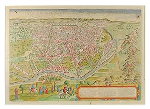
Cairus Quae Olim Babylon Aegypt Maxima Urbs. (Birds eye view of Cairo). In "Civitates Orbis Terrarum" Vol. I.
Librería: John Windle Antiquarian Bookseller, ABAA, San Francisco, CA, Estados Unidos de America
Miembro de asociación: ABAA ILAB IOBA
Valoración del vendedor:
Cologne, 1572-1617. 18 7/8 x 12.75 inches. Framed map, hand colored; one small hole and one small spot in the margin, one small hole and one small spot within the plate, frame lightly scuffed, over all very good condition. Not examined out of frame. § Fine example with early coloring of this important early view of Cairo from a hillside opposite the Nile, from Braun & Hogenberg's Civitates Orbis Terrarum, the most important "town book" of the 16th Century. The view incorporates elaborate detail, including fortified walls and buildings, and a number of horsemen and other costumed figures in the foreground. Georg Braun's commentary on the view translates as follows: "Cairo is said to number 30,000 houses altogether. There are very many princely palaces and temples here, but also many hospices, schools and baths and large buildings containing the tombs of important persons. The streets contain such a throng of people, horses and mules that it is not possible to pass without obstacle. [.] The women, too, wear trousers, made of silk, trimmed with pearls and precious gems, like the men. The men are also allowed to have several wives."Georg Braun (1541-1622) was born and died in Cologne. His primary vocation was as Catholic cleric; he spent thirty-seven years as canon and dean at the church St. Maria ad Gradus. Braun was the chief editor of the Civitates orbis terrarum, the greatest book of town views ever published. His job entailed hiring artists, acquiring source material for the maps and views, and writing the text, assisted by Abraham Ortelius. Braun lived into his 80s, and he was the only member of the original team to witness the publication of the sixth volume in 1617.
-
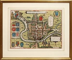
Cestria (Vulgo) Chester, Angliae Civitates.
Publicado por Cologne: 1581, 1581
Librería: Peter Harrington. ABA/ ILAB., London, Reino Unido
Miembro de asociación: ABA ILAB PBFA
Valoración del vendedor:
This wonderful, early plan of Chester was published in the third volume (of 6) of Braun and Hogenberg's epic work 'Civitates Orbis Terrarum'; published between 1572 and 1617. This monumental city atlas contained some 546 bird's eye city prospects and map plans. The work was originally published to accompany Abraham Ortelius' great atlas; the Theatrum Orbis Terrarum of 1570. This plan of Chester depicts it in Elizabethan times, with appropriate attired figures in the foreground, a inscription in Latin, numerous aristocratic and royal heraldic shields, and the coats of arms of the city itself and of the bishop of the city. The river Dee divides England from Wales and all of the principal buildings and fortifications within the city are listed and numbered. Chester was founded by the Romans, serving legion that was posted there to ward off the Celtic Welsh as an important harbour and defensive position. Following the withdrawal of the Romans, the Saxons extended the walls in order to protect the city against incursions by the Danes. Taschen. Framed size: 510 x 600 mm. Copperplate engraving with hand colour. Latin text on verso Fine condition.
