Importe total (1 artículo artículos):
Destino del pedido:

BOWEN, EMANUEL & THOMAS KITCHIN (4 resultados)
Ir a los resultados principales
Tipo de artículo
- Todo tipo de artículos
- Libros (4)
- Revistas y publicaciones
- Cómics
- Partituras
- Arte, grabados y pósters
- Fotografías
- Mapas
-
Manuscritos y
coleccionismo de papel
Condición
- Todo
- Nuevos
- Antiguos o usados
Encuadernación
- Todo
- Tapa dura (1)
- Tapa blanda
Más atributos
- Primera edición
- Firmado
- Sobrecubierta
- Con imágenes del vendedor (3)
- Sin impresión bajo demanda
Ubicación del vendedor
Valoración de los vendedores
-
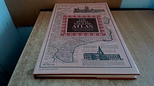
The Royal English atlas: Eighteenth Century county maps of England and Wales
Publicado por David & Charles, 1971
ISBN 10: 0715351001ISBN 13: 9780715351000
Librería: Cotswold Internet Books, Cheltenham, Reino Unido
Valoración del vendedor:

Libro
New edition. Tiny dent in bottom edge of front board, otherwise a tidy hardback in tight binding; dust jacket a little worn at edges. This is a heavy book (about 2.4kg packed); additional postage may be required Used - Very Good. VG hardback in Good dust jacket.
-
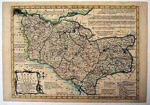
KENT DIVIDED INTO ITS LATHES. AND SUBDIVIDED INTO HUNDREDS; EXHIBITING THE CITIES, BOROUGH AND MARKET TOWNS WITH CONCISE HISTORICAL EXTRACTS, RELATING TO TRADE AND MANUFACTURERS. DESCRIBING ALSO THE CHURCH LIVINGS WITH IMPROVEMENTS NOT INSERTED IN ANY OTHER SET OF HALF SHEET COUNTY MAPS EXTANT.
Publicado por [Thomas Kitchin in Atlas Anglicanus], 1767
Librería: Marrins Bookshop, Folkestone, KENT, Reino Unido
Miembro de asociación: ABA ILAB PBFA
Valoración del vendedor:
Hand-coloured copper engraving. 9 x 12.5 inches. A fine example in very attractive colour. Atlas Anglicanus was first published in 1767 by Thomas Kitchin issuing the Bowens' large maps on a reduced scale making them more easily affordable. Such was its popularity that a second edition was issued in 1777. KENT MAPS KENT MAPS- 18TH CENTURY KENT.
-
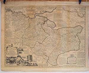
AN ACCURATE MAP OF THE COUNTY OF KENT DIVIDED INTO ITS LATHES, AND SUBDIVIDED INTO HUNDREDS. DRAWN FROM SURVEYS, AND MOST APPROVED MODERN MAPS, WITH VARIOUS ADDITIONAL IMPROVEMENTS: ILLUSTRATED WITH HISTORICAL EXTRACTS, RELATIVE TO THE AIR, SOIL, NATURAL PRODUCE, MANUFACTURES, TRADE AND PRESENT STATE OF ITS CITIES AND PRINCIPAL TOWNS. BY EMAN: BOWEN GEOGRAPHER TO HIS MAJESTY.
Publicado por Printed for Rt. Wilkinson in Cornhill Carington Bowles in St. Pauls Churchyard and Robt. Sayer in Fleet Street. Not dated but known to be [1760], London, 1760
Librería: Marrins Bookshop, Folkestone, KENT, Reino Unido
Miembro de asociación: ABA ILAB PBFA
Valoración del vendedor:
Original copper engraved map, 21 x 28 inches, with good margins, in original outline hand-colouring. A few clean example This is the largest of Bowen's classic eighteenth century maps of the county. From Bowen and Kitchin's Large English Atlas which was published over a period of eleven years between 1749 and 1760, and forms a highly important series of large scale English county maps, some of the best produced in the eighteenth century. Crammed with information, detailed notes of historical and topographical facts fill all the available space surrounding the map. Inset is a chart of the Downs and, completing this imposing sheet, a large pictorial and allegorical cartouche depicting the maritime and agricultural importance of the county. Emanuel Bowen (1694-1767) was a Welsh engraver, who produced some of the largest and most detailed maps of the age, becoming Royal mapmaker to both George II and Louis XV. KENT MAPS KENT MAPS- 18TH CENTURY KENT.
-
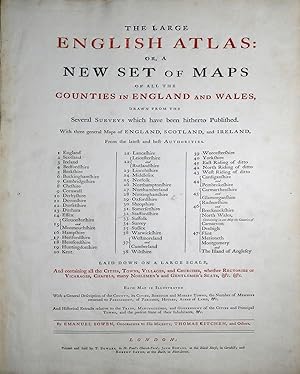
The Large English Atlas, or, a New Set of Maps of all the Counties in England and Wales, Drawn from the Several Surveys which have been hitherto Published. With three general Maps of England, Scotland, and Ireland.
Publicado por London: Printed and Sold by T. Bowles, in St. Paul's Church-Yard; John Bowles, at the Black Horse, in Cornhill; and Robert Sayer, at the Buck, in Fleet-Street, [1763], 1763
Librería: Arader Galleries - AraderNYC, New York, NY, Estados Unidos de America
Valoración del vendedor:
Folio (22 1/2 x 15 1/4 in.; 57.2 x 38.7 cm). Title printed in red and black incorporating general index, 50 engraved maps on 47 double-folding sheets, hand-colored in outline, with cartouches, vignettes, and inset plans, mounted on guards. BINDING/CONDITION: Map of Kent with centerfold split, England & Wales, Suffolk, Oxfordshire and Surrey with shorter splits. Contemporary calf, red morocco spine label, extremities worn with some tears, joints split, upper cover nearly detached. (64F5C) Emanuel Bowen's contribution to eighteenth-century British atlases is substantial. Using contemporary sources, he published and drew maps the county maps in his "Large English Atlas," the first to cover England and Wales on a large scale, which were subsequently reduced by Bowen and Kitchin for their "Royal English Atlas" and then by Emanuel and Thomas Bowen for "Atlas Anglicanus," published after Emanuel Bowen's death by Kitchin. "All three works are characterized by detailed texts in the spaces surrounding the maps and by elegant rococo decoration, which became the hallmark of his engraving" (DNB). PROVENANCE: Bonham's London, 7 March 2019, lot 59. REFERENCE: Chubb CXCVII.