Importe total (1 artículo artículos):
Destino del pedido:

BIEN, JULIUS (263 resultados)
Ir a los resultados principales
Tipo de artículo
- Todo tipo de artículos
- Libros (170)
- Revistas y publicaciones
- Cómics
- Partituras
- Arte, grabados y pósters (16)
- Fotografías
- Mapas (77)
-
Manuscritos y
coleccionismo de papel
Condición
Encuadernación
Más atributos
- Primera edición (145)
- Firmado
- Sobrecubierta (1)
- Con imágenes del vendedor (242)
- Sin impresión bajo demanda (262)
Gastos de envío gratis
Ubicación del vendedor
Valoración de los vendedores
-
![Imagen del vendedor de Death and Burial of Poor Cock Robin: Illustrated [Soft Cover ] a la venta por booksXpress](https://pictures.abebooks.com/inventory/md/md31452968604.jpg)
Death and Burial of Poor Cock Robin: Illustrated [Soft Cover ]
Publicado por CreateSpace Independent Publishing Platform, 2016
ISBN 10: 1537654888ISBN 13: 9781537654881
Librería: booksXpress, Bayonne, NJ, Estados Unidos de America
Valoración del vendedor:

Libro
Soft Cover. Condición: new. Bien, Julius Ilustrador.
-
Condición: Good. USA. Constituents of population states & Territories. 1900 old antique map. Colour antique map; Julius Bien (1900). 22.5 x 15.0cm, 9 x 5.75 inches. Condition: Good. There is nothing printed on the reverse side, which is plain.
-
Condición: Fair. USA. Constituents of the male population of Voting age. 1900 old antique map. Colour antique map; Julius Bien (1900). 22.0 x 15.0cm, 8.75 x 5.75 inches. Condition: Fair: Blemishes. There is nothing printed on the reverse side, which is plain.
-
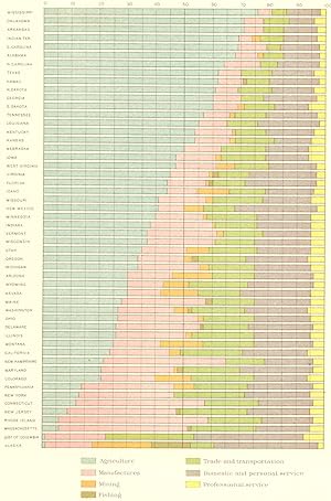
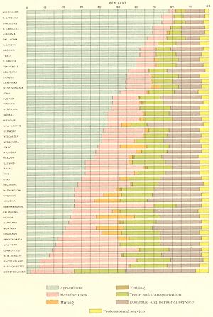
Condición: Good. USA. Proportions of people engaged in each class occupations. 1900 old map. Colour antique map; Julius Bien (1900). 22.0 x 14.5cm, 8.75 x 5.75 inches. Condition: Good. There is nothing printed on the reverse side, which is plain.
-
Condición: Good. USA. Apricots principal regions of production. 1900 old antique map chart. Colour antique map; Julius Bien (1900). 11.0 x 16.5cm, 4.25 x 6.5 inches. Condition: Good. There is nothing printed on the reverse side, which is plain.
-
Condición: Good. USA. Cotton production, exports and consumption. 1850 to 1900 1900 old map. Colour antique map; Julius Bien (1900). 21.0 x 16.5cm, 8.25 x 6.5 inches. Condition: Good. There is nothing printed on the reverse side, which is plain.
-
Proportion of the number of farms of specified area: 1900; Classified by tenure; Classified by race of occupants; Classified by Principal crops; Classified by amount of income
Ańo de publicación: 1900
Mapa
Condición: Good. USA. Proportion of farms, area. ; tenure; race; crops; income 1900 old map. Colour antique map; Julius Bien (1900). 22.5 x 16.0cm, 8.75 x 6.25 inches. Condition: Good. There is nothing printed on the reverse side, which is plain.
-
Condición: Good. USA. Cherries principal regions of production. 1900 old antique map chart. Colour antique map; Julius Bien (1900). 11.0 x 16.5cm, 4.25 x 6.5 inches. Condition: Good. There is nothing printed on the reverse side, which is plain.
-
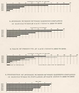
Condición: Good. USA. Products. investment Payroll Production Employment %, 1850-1900 1900 map. Antique map; Julius Bien (1900). 18.5 x 15.5cm, 7.25 x 6 inches. Condition: Good. There is nothing printed on the reverse side, which is plain.
-
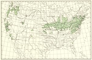
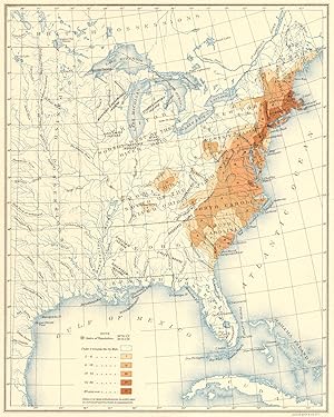
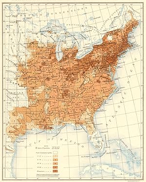
Condición: Good. USA. Population distribution. 1790 1900 old antique vintage map plan chart. Colour antique map; Julius Bien (1900). 21.0 x 16.5cm, 8.25 x 6.5 inches. Condition: Good. There is nothing printed on the reverse side, which is plain.
-
Condición: Good. USA. Constituents of the male population of Militia age. 1900 old antique map. Colour antique map; Julius Bien (1900). 22.0 x 15.0cm, 8.5 x 5.75 inches. Condition: Good. There is nothing printed on the reverse side, which is plain.
-
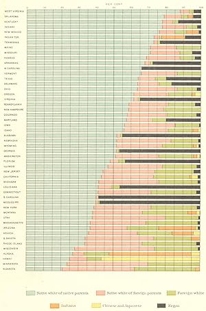
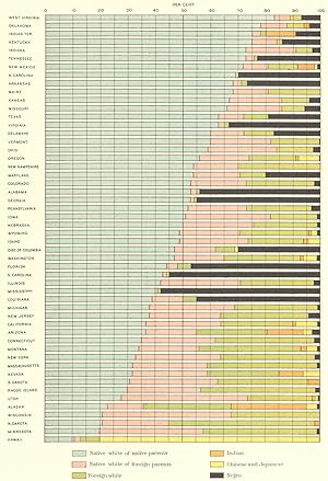
Conjugal condition of the population by age and sex in proportions of the total number of each age group: 1900; Aggregate population: 1900; Aggregate population: 1890; Native white of native parents: 1900; Native white of foreign parents: 1900
Ańo de publicación: 1900
Mapa
Condición: Good. USA. Conjugal marital status demographics, 1890-1900 1900 old antique map. Colour antique map; Julius Bien (1900). 22.5 x 15.5cm, 8.75 x 6 inches. Condition: Good. There is nothing printed on the reverse side, which is plain.
-
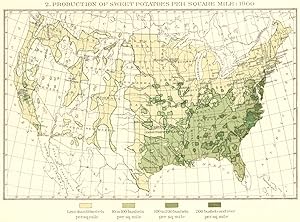
Condición: Good. USA. Production of Sweet potatoes per square mile. 1900 old antique map chart. Colour antique map; Julius Bien (1900). 12.5 x 17.0cm, 4.75 x 6.5 inches. Condition: Good. There is nothing printed on the reverse side, which is plain.
-
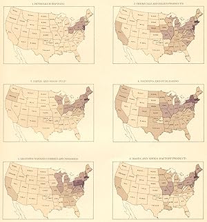
Value of products of manufactures per square mile: 1900; 1. Petroleum refining; 2.Chemicals and Allied products; 3. Paper and wood pulp; 4. Printing and publishing; 5. Leather (Tanned, curried and finished); 6. Boots and shoes (Factory Product)
Ańo de publicación: 1900
Mapa
Condición: Good. USA. Petroleum Chemical Paper wood pulp Printing Leather Boot shoe 1900 map. Colour antique map; Julius Bien (1900). 19.5 x 18.0cm, 7.75 x 7.25 inches. Condition: Good. There is nothing printed on the reverse side, which is plain.
-
Condición: Good. USA. Population distribution. 1800 1900 old antique vintage map plan chart. Colour antique map; Julius Bien (1900). 21.0 x 16.5cm, 8.25 x 6.5 inches. Condition: Good. There is nothing printed on the reverse side, which is plain.
-
Distribution of persons born in each specified state and territory who are living in other states and territories: 1900
Ańo de publicación: 1900
Mapa
Condición: Good. USA. People born, state living elsewhere census 1900 old antique map chart. Colour antique map; Julius Bien (1900). 20.0 x 15.5cm, 7.75 x 6.25 inches. Condition: Good. There is nothing printed on the reverse side, which is plain.
-
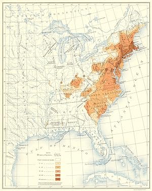
Foreign born at each census, with the proportion of each leading nationality: 1850 to 1900
Ańo de publicación: 1900
Mapa
Condición: Good. USA. Foreign born each census, % leading nationality. 1850 1900 1900 old map. Colour antique map; Julius Bien (1900). 21.5 x 17.0cm, 8.5 x 6.75 inches. Condition: Good. There is nothing printed on the reverse side, which is plain.
-
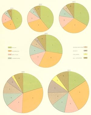
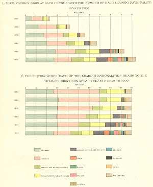
1. Total Foreign born at each census with the number of each leading nationality: 1850 to 1900; 2. Proportion which each of the leading Nationalities bears to the total foreign born at each census: 1850 to 1900
Ańo de publicación: 1900
Mapa
Condición: Good. USA. Foreign born, nationality. 1850 to 1900 census; number & % 1900 old map. Colour antique map; Julius Bien (1900). 21.0 x 16.0cm, 8.25 x 6.25 inches. Condition: Good. There is nothing printed on the reverse side, which is plain.
-
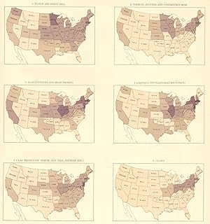
Value of products of manufactures per square mile: 1900; 1. Flour and Grist Mill; 2. Cheese, butter and condensed milk; 3. Slaughtering and meat packing; 4. Liquors (Distilled, Malt and vinous); 5. Clay products (brick and tile, pottery etc); 6. Glass
Ańo de publicación: 1900
Mapa
Condición: Good. USA. Output density. Flour; Dairy; Livestock; Liquor; Clay; Glass, 1900 map. Colour antique map; Julius Bien (1900). 19.5 x 18.5cm, 7.75 x 7.25 inches. Condition: Good. There is nothing printed on the reverse side, which is plain.
-
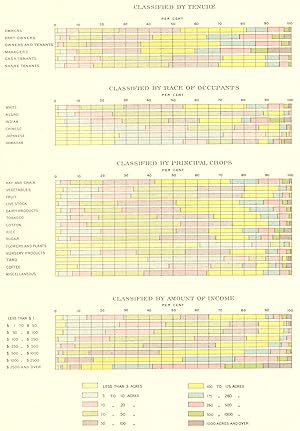
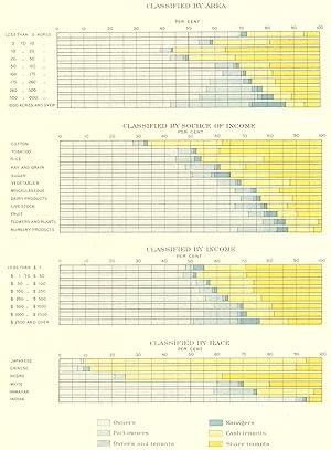
Percentages of the number of farms, of specified tenures: 1900; Classified by area; Classified by source of income; Classified by income; Classified by race
Ańo de publicación: 1900
Mapa
Condición: Good. USA. Percentages of farms, tenure. ; area; source income; race 1900 old map. Colour antique map; Julius Bien (1900). 21.0 x 15.5cm, 8.25 x 6.25 inches. Condition: Good. There is nothing printed on the reverse side, which is plain.
-
Condición: Good. USA. Peaches & Nectarines main of production. 1900 old antique map plan chart. Colour antique map; Julius Bien (1900). 11.0 x 17.0cm, 4.25 x 6.5 inches. Condition: Good. There is nothing printed on the reverse side, which is plain.
-
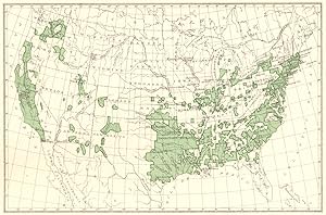
Condición: Good. USA. Population distribution East of the 100th Meridian. 1860 1900 old map. Colour antique map; Julius Bien (1900). 21.0 x 17.0cm, 8.25 x 6.5 inches. Condition: Good. There is nothing printed on the reverse side, which is plain.
-
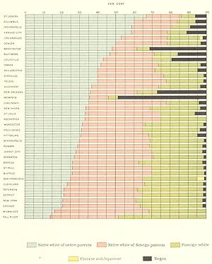
Constituents of the population of cities of more than 100,000 inhabitants: 1900
Ańo de publicación: 1900
Mapa
Condición: Good. USA. Constituents population cities more than 100, 000 inhabitants. 1900 map. Colour antique map; Julius Bien (1900). 18.5 x 14.5cm, 7.25 x 5.75 inches. Condition: Good. There is nothing printed on the reverse side, which is plain.
-
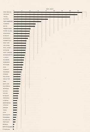
Proportion of White Persons of foreign parentage, 10 years of age and over, who cannot speak English: 1900
Ańo de publicación: 1900
Mapa
Condición: Fair. USA. % White people foreign parentage, 10 yrs age, can't speak English 1900 map. Colour antique map; Julius Bien (1900). 20.5 x 14.0cm, 8.25 x 5.5 inches. Condition: Fair: Creased. There is nothing printed on the reverse side, which is plain.
-
Condición: Good. USA. Proportions of people engaged in each class occupations. 1890 1900 map. Colour antique map; Julius Bien (1900). 22.0 x 14.5cm, 8.75 x 5.75 inches. Condition: Good. There is nothing printed on the reverse side, which is plain.
-
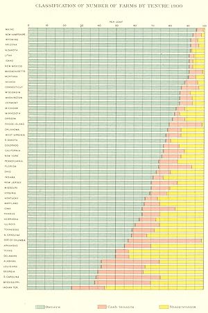
Condición: Good. USA. Classification of number of farms by tenure. 1900 old antique map chart. Colour antique map; Julius Bien (1900). 21.0 x 14.5cm, 8.25 x 5.75 inches. Condition: Good. There is nothing printed on the reverse side, which is plain.
-
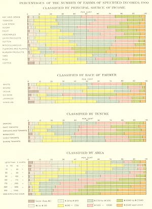
Percentages of the number of farms of specified incomes: 1900; Classified by principal source of income; Classified by Race of Farmer; Classified by Tenure; Classified by Area
Ańo de publicación: 1900
Mapa
Condición: Good. USA. Agriculture. Farms, income bracket; Source of; Race; Tenure; area 1900 map. Colour antique map; Julius Bien (1900). 21.0 x 16.0cm, 8.25 x 6.25 inches. Condition: Good. There is nothing printed on the reverse side, which is plain.
-
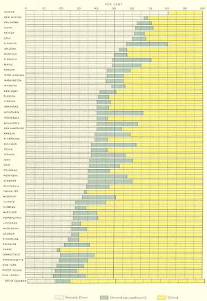
Condición: Good. USA. Proportion of homes owned free, encumbered & Hired. 1900 old antique map. Colour antique map; Julius Bien (1900). 21.5 x 14.5cm, 8.5 x 5.75 inches. Condition: Good. There is nothing printed on the reverse side, which is plain.
-
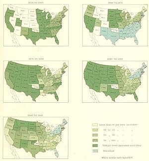
Percentage of increase in the value of farms and improvements: 1850 to 1900
Ańo de publicación: 1900
Mapa
Condición: Good. USA. % of increase, value farms &. 1850 to 1900 1900 old antique map chart. Colour antique map; Julius Bien (1900). 19.5 x 18.0cm, 7.75 x 7.25 inches. Condition: Good. There is nothing printed on the reverse side, which is plain.
-
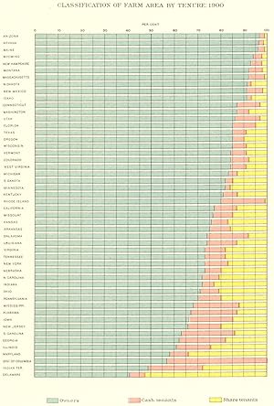
Condición: Good. USA. Classification of farm area by tenure. 1900 old antique map plan chart. Colour antique map; Julius Bien (1900). 21.0 x 15.0cm, 8.25 x 5.75 inches. Condition: Good. There is nothing printed on the reverse side, which is plain.