
Importe total (1 artículo artículos):
Destino del pedido:

BEERS, F W ASSISTED BY GEO WARNER (35 resultados)
Ir a los resultados principales
Tipo de artículo
- Todo tipo de artículos
- Libros (35)
- Revistas y publicaciones
- Cómics
- Partituras
- Arte, grabados y pósters
- Fotografías
- Mapas
-
Manuscritos y
coleccionismo de papel
Condición
- Todo
- Nuevos
- Antiguos o usados
Encuadernación
- Todo
- Tapa dura (3)
- Tapa blanda
Más atributos
- Primera edición (1)
- Firmado
- Sobrecubierta
- Con imágenes del vendedor (29)
- Sin impresión bajo demanda
Ubicación del vendedor
Valoración de los vendedores
-

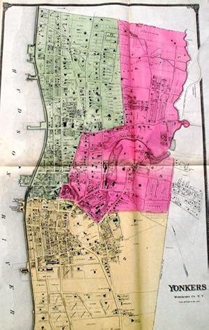
Town of Yonkers
Publicado por F. W. Beers, New York, 1867
Librería: Antipodean Books, Maps & Prints, ABAA, Garrison, NY, Estados Unidos de America
Miembro de asociación: ABAA ANZAAB ESA ILAB
Valoración del vendedor:

Condición: Very good. 14.5 by 17.5 inches engraved map. This is from the Beers atlas that includes Westchester, Putnam & Dutchess County, which is unusual. Very good condition.
-

Plans of East Chester, Pelham, and New Rochelle
Publicado por F. W. Beers, New York, 1867
Librería: Antipodean Books, Maps & Prints, ABAA, Garrison, NY, Estados Unidos de America
Miembro de asociación: ABAA ANZAAB ESA ILAB
Valoración del vendedor:
Condición: Very good condition. 14.5 by 17.5 inches engraved map. This is from the Beers atlas.
-
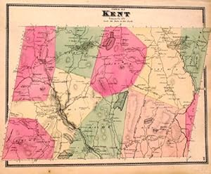
Town of Kent
Publicado por F. W. Beers, New York, 1867
Librería: Antipodean Books, Maps & Prints, ABAA, Garrison, NY, Estados Unidos de America
Miembro de asociación: ABAA ANZAAB ESA ILAB
Valoración del vendedor:
Condición: Very good. 14.5 by 17.5 inches engraved map. This is from the Beers atlas that includes Westchester, Putnam & Dutchess County, which is unusual. Very good condition.
-
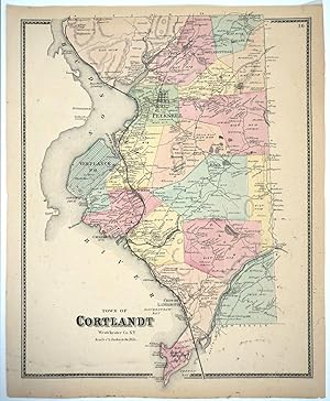
Town of Cortlandt. Original color map
Publicado por F. W. Beers, New York, 1867
Librería: Antipodean Books, Maps & Prints, ABAA, Garrison, NY, Estados Unidos de America
Miembro de asociación: ABAA ANZAAB ESA ILAB
Valoración del vendedor:
Condición: Very good overall. A lithograph map of this Westchester NY town, which extends from Peekskill down to Croton Point. From the Beers atlas that includes Westchester, Putnam & Dutchess County. 14.5 by 17.5".
-
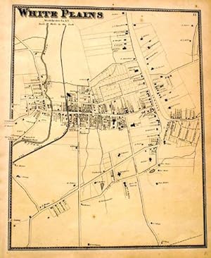
White Plains
Publicado por F. W. Beers, New York, 1867
Librería: Antipodean Books, Maps & Prints, ABAA, Garrison, NY, Estados Unidos de America
Miembro de asociación: ABAA ANZAAB ESA ILAB
Valoración del vendedor:
Condición: Very good. 14.5 by 17.5 inches engraved map. This is from the Beers atlas that includes Westchester, Putnam & Dutchess County, which is unusual. Very good condition.
-
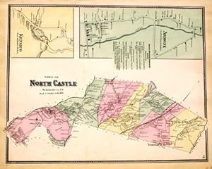
Town of North Castle, Including Armonk and Kensico
Publicado por F. W. Beers, New York, 1867
Librería: Antipodean Books, Maps & Prints, ABAA, Garrison, NY, Estados Unidos de America
Miembro de asociación: ABAA ANZAAB ESA ILAB
Valoración del vendedor:
Condición: Very good. 14.5 by 17.5 inches engraved map. This is from the Beers atlas that includes Westchester, Putnam & Dutchess County, which is unusual. Very good condition.
-
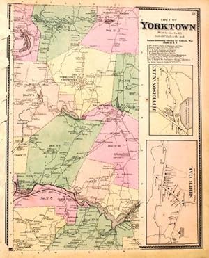
Town of Yorktown
Publicado por F. W. Beers, New York, 1867
Librería: Antipodean Books, Maps & Prints, ABAA, Garrison, NY, Estados Unidos de America
Miembro de asociación: ABAA ANZAAB ESA ILAB
Valoración del vendedor:
Condición: Very good. 14.5 by 17.5 inches engraved map. This is from the Beers atlas that includes Westchester, Putnam & Dutchess County, which is unusual. Very good condition.
-
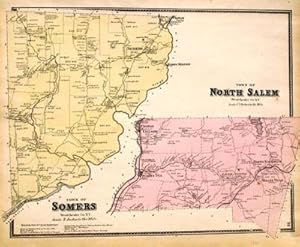
Town of Somers, Town of North Salem
Publicado por F. W. Beers, New York, 1867
Librería: Antipodean Books, Maps & Prints, ABAA, Garrison, NY, Estados Unidos de America
Miembro de asociación: ABAA ANZAAB ESA ILAB
Valoración del vendedor:
Condición: Very good. 14.5 by 17.5 inches engraved map. This is from the Beers atlas that includes Westchester, Putnam & Dutchess County, which is unusual. Very good condition.
-
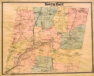
Town of South East
Publicado por F. W. Beers, New York, 1867
Librería: Antipodean Books, Maps & Prints, ABAA, Garrison, NY, Estados Unidos de America
Miembro de asociación: ABAA ANZAAB ESA ILAB
Valoración del vendedor:
Condición: Very good. 14.5 by 17.5 inches engraved map. This is from the Beers atlas that includes Westchester, Putnam & Dutchess County, which is unusual. Very good condition.
-
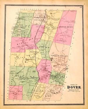
Dover
Publicado por F. W. Beers, New York, 1867
Librería: Antipodean Books, Maps & Prints, ABAA, Garrison, NY, Estados Unidos de America
Miembro de asociación: ABAA ANZAAB ESA ILAB
Valoración del vendedor:
Condición: Very good. 14.5 by 17.5 inches engraved map. This is from the Beers atlas that includes Westchester, Putnam & Dutchess County, which is unusual. Very good condition.
-
Town of Beekman
Publicado por F. W. Beers, New York, 1867
Librería: Antipodean Books, Maps & Prints, ABAA, Garrison, NY, Estados Unidos de America
Miembro de asociación: ABAA ANZAAB ESA ILAB
Valoración del vendedor:
Condición: Very good. 14.5 by 17.5 inches engraved map which includes views of Poughquag, Beekmanville, and Green Haven. This is from the Beers atlas that includes Westchester, Putnam & Dutchess County, which is unusual. Very good condition.
-
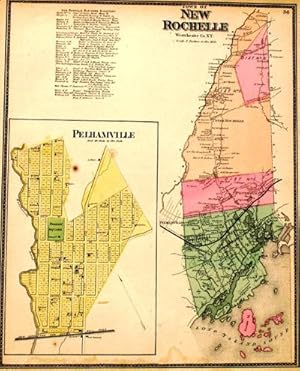
Town of New Rochelle
Publicado por F. W. Beers, New York, 1867
Librería: Antipodean Books, Maps & Prints, ABAA, Garrison, NY, Estados Unidos de America
Miembro de asociación: ABAA ANZAAB ESA ILAB
Valoración del vendedor:
Condición: Very good. 14.5 by 17.5 inches engraved map. Includes a view of Pelhamville. This is from the Beers atlas that includes Westchester, Putnam & Dutchess County, which is unusual. Very good condition.
-
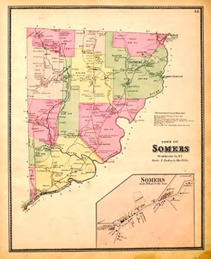
Town of Somers
Publicado por F. W. Beers, New York, 1867
Librería: Antipodean Books, Maps & Prints, ABAA, Garrison, NY, Estados Unidos de America
Miembro de asociación: ABAA ANZAAB ESA ILAB
Valoración del vendedor:
Condición: Very good. 14.5 by 17.5 inches engraved map. This is from the Beers atlas that includes Westchester, Putnam & Dutchess County, which is unusual. Very good condition.
-
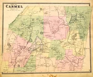
Town of Carmel
Publicado por F. W. Beers, New York, 1867
Librería: Antipodean Books, Maps & Prints, ABAA, Garrison, NY, Estados Unidos de America
Miembro de asociación: ABAA ANZAAB ESA ILAB
Valoración del vendedor:
Condición: Very good. 14.5 by 17.5 inches engraved map. This is from the Beers atlas that includes Westchester, Putnam & Dutchess County, which is unusual. Very good condition.
-
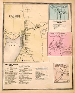
Carmel, Towners Station, South East Centre, Mill Town
Publicado por F. W. Beers, New York, 1867
Librería: Antipodean Books, Maps & Prints, ABAA, Garrison, NY, Estados Unidos de America
Miembro de asociación: ABAA ANZAAB ESA ILAB
Valoración del vendedor:
Condición: Very good. 14.5 by 17.5 inches engraved map with separate views of Carmel, Towners Station, South East Centre, and Mill Town. This is from the Beers atlas that includes Westchester, Putnam & Dutchess County, which is unusual. Very good condition.
-
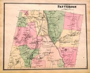
Town of Patterson
Publicado por F. W. Beers, New York, 1867
Librería: Antipodean Books, Maps & Prints, ABAA, Garrison, NY, Estados Unidos de America
Miembro de asociación: ABAA ANZAAB ESA ILAB
Valoración del vendedor:
Condición: Very good. 14.5 by 17.5 inches engraved map. This is from the Beers atlas that includes Westchester, Putnam & Dutchess County, which is unusual. Very good condition.
-
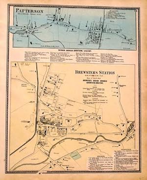
Patterson, Brewsters Station
Publicado por F. W. Beers, New York, 1867
Librería: Antipodean Books, Maps & Prints, ABAA, Garrison, NY, Estados Unidos de America
Miembro de asociación: ABAA ANZAAB ESA ILAB
Valoración del vendedor:
Condición: Very good. 14.5 by 17.5 inches engraved map with separate views of Patterson and Brewsters Station. This is from the Beers atlas that includes Westchester, Putnam & Dutchess County, which is unusual. Very good condition.
-

Town of Poughkeepsie
Publicado por F. W. Beers, New York, 1867
Librería: Antipodean Books, Maps & Prints, ABAA, Garrison, NY, Estados Unidos de America
Miembro de asociación: ABAA ANZAAB ESA ILAB
Valoración del vendedor:
Condición: Very good. 14.5 by 17.5 inches engraved map which includes a view of New Hamburgh. This is from the Beers atlas that includes Westchester, Putnam & Dutchess County, which is unusual. Very good condition.
-

Plan of Peekskill
Publicado por F. W. Beers, New York, 1867
Librería: Antipodean Books, Maps & Prints, ABAA, Garrison, NY, Estados Unidos de America
Miembro de asociación: ABAA ANZAAB ESA ILAB
Valoración del vendedor:
Condición: Very good. 26 by 20 inches engraved map on onion paper. Includes a plan of Cortlandt Cemetery. This is from the Beers atlas that includes Westchester, Putnam & Dutchess County, which is unusual. Very good condition.
-

Mamaroneck, Scarsdale, White Plains, Harrison & Rye
Publicado por F. W. Beers, New York, 1867
Librería: Antipodean Books, Maps & Prints, ABAA, Garrison, NY, Estados Unidos de America
Miembro de asociación: ABAA ANZAAB ESA ILAB
Valoración del vendedor:
Condición: Very good. 14.5 by 17.5 inches engraved map. This is from the Beers atlas that includes Westchester, Putnam & Dutchess County, which is unusual. Very good condition.
-
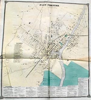
Portchester
Publicado por F. W. Beers, New York, 1867
Librería: Antipodean Books, Maps & Prints, ABAA, Garrison, NY, Estados Unidos de America
Miembro de asociación: ABAA ANZAAB ESA ILAB
Valoración del vendedor:
Condición: Very good. 23 by 26 inches engraved map on onion paper. This is from the Beers atlas that includes Westchester, Putnam & Dutchess County, which is unusual. Very good condition.
-
Town of Channingville, Wappinger's Falls
Publicado por F. W. Beers, New York, 1867
Librería: Antipodean Books, Maps & Prints, ABAA, Garrison, NY, Estados Unidos de America
Miembro de asociación: ABAA ANZAAB ESA ILAB
Valoración del vendedor:
Condición: Very good. 14.5 by 17.5 inches engraved map. This is from the Beers atlas that includes Westchester, Putnam & Dutchess County, which is unusual. Very good condition.
-
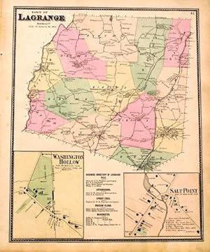
Town of Lagrange
Publicado por F. W. Beers, New York, 1867
Librería: Antipodean Books, Maps & Prints, ABAA, Garrison, NY, Estados Unidos de America
Miembro de asociación: ABAA ANZAAB ESA ILAB
Valoración del vendedor:
Condición: Very good. 14.5 by 17.5 inches engraved map which includes views of Washington Hollow and Salt Point. This is from the Beers atlas that includes Westchester, Putnam & Dutchess County, which is unusual. Very good condition.
-
Yonkers
Publicado por F. W. Beers, New York, 1867
Librería: Antipodean Books, Maps & Prints, ABAA, Garrison, NY, Estados Unidos de America
Miembro de asociación: ABAA ANZAAB ESA ILAB
Valoración del vendedor:
Condición: Very good. 34 by 20 inches engraved map on onion paper. This is from the Beers atlas that includes Westchester, Putnam & Dutchess County, which is unusual. Very good condition.
-

Town of North Salem
Publicado por F. W. Beers, New York, 1867
Librería: Antipodean Books, Maps & Prints, ABAA, Garrison, NY, Estados Unidos de America
Miembro de asociación: ABAA ANZAAB ESA ILAB
Valoración del vendedor:
Condición: Very good. 14.5 by 17.5 inches engraved map. Includes views of Croton Falls, North Salem, and Purdy Station. This is from the Beers atlas that includes Westchester, Putnam & Dutchess County, which is unusual. Very good condition.
-
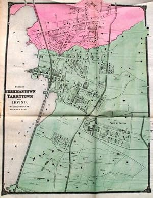
Plan of Beekmantown, Tarrytown, and Irving
Publicado por F. W. Beers, New York, 1867
Librería: Antipodean Books, Maps & Prints, ABAA, Garrison, NY, Estados Unidos de America
Miembro de asociación: ABAA ANZAAB ESA ILAB
Valoración del vendedor:
Condición: Very good. 23 by 24 inches engraved map on onion paper. This is from the Beers atlas that includes Westchester, Putnam & Dutchess County, which is unusual. Very good condition.
-
Fishkill Dutchess Co. NY. [with insets of Carthage Landing, Hughsonville, New Hackensack and Glenham]
Publicado por F. W. Beers, New York, 1867
Librería: Antipodean Books, Maps & Prints, ABAA, Garrison, NY, Estados Unidos de America
Miembro de asociación: ABAA ANZAAB ESA ILAB
Valoración del vendedor:
Condición: Very good overall. Map of the western part of Dutchess County from the Putnam border to La Grange. From the Beers atlas that includes Westchester, Putnam & Dutchess County, most interesting for the locations and names of land owners at the time. Paper with original folds but reasonably flat. Business directories of Carthage Landing Hughsonville & Glenham. Also "Names of Heads of 67 Families, living in Dutchess County, in the year 1714." 18 x 23 1/4" plus margins. Steel engraving with original wash color.
-
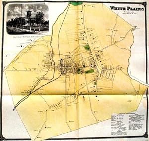
Large Map of White Plains with Vignette Views
Publicado por F. W. Beers, New York, 1867
Librería: Antipodean Books, Maps & Prints, ABAA, Garrison, NY, Estados Unidos de America
Miembro de asociación: ABAA ANZAAB ESA ILAB
Valoración del vendedor:
Condición: Very good. 23 by 23 inches engraved map on onion paper. with vingette views. This is from the Beers atlas that includes Westchester, Putnam & Dutchess County, which is unusual. Very good condition with two repaired tears on top edge.
-
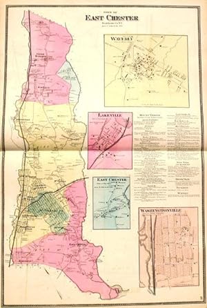
Eastchester, NY including Bronxville, Washingtonville, Lakeville, Eastchester, Mt. Vernon, Waverly and Tuckahoe
Publicado por F. W. Beers, New York, 1867
Librería: Antipodean Books, Maps & Prints, ABAA, Garrison, NY, Estados Unidos de America
Miembro de asociación: ABAA ANZAAB ESA ILAB
Valoración del vendedor:
Condición: Very good. 17.5 by 26 inches engraved map. This is from the Beers atlas that includes Westchester, Putnam & Dutchess County, which is unusual. Very good condition.
-
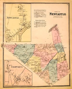
Town of Newcastle
Publicado por F. W. Beers, New York, 1867
Librería: Antipodean Books, Maps & Prints, ABAA, Garrison, NY, Estados Unidos de America
Miembro de asociación: ABAA ANZAAB ESA ILAB
Valoración del vendedor:
Condición: Very good. 14.5 by 17.5 inches engraved map. Includes views of Newcastle and Chappaqua. This is from the Beers atlas that includes Westchester, Putnam & Dutchess County, which is unusual. Very good condition.
