Descripción
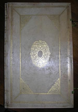
Folio (22 x 14 inches). Letterpress title-page within elaborate engraved allegorical border incorporating vignette, dedication to Johann de Witt, 41 double-page or folding engraved sea- and coastal charts, including the additional CHART OF NEW JERSEY, the chart of the Zuyder Zee extended to include Harderwijck, THE TITLE-PAGE AND ALL CHARTS RICHLY COLORED BY A CONTEMPORARY HAND, the maps in outline, the cartouches fully, title cartouches and embellishments HEIGHTENED WITH GOLD (title-page and first leaf remargined, a few charts with short splits or creases to the centerfolds, restoration to the blank margins of the first map and leaves, some adhesion damage affecting the title-page and a few maps, some separation or creasing to lower centerfolds, the creasing particularly affecting the New Jersey map). Contemporary Dutch vellum gilt, each cover decorated with large corner pieces and central cartouche, the spine decorated with gilt Tudor rose tools, green silk ties, all edges gilt (remboitage, paste-board renewed). Provenance: Christopher Henry Beaumont Pease, Lord Wardington (1924-2005), Library of Important Atlases and Geographies, his sale Sotheby's 18th October 2005, lot 177. Fifth edition, first published in 1666, and based on Hendrick Doncker's "Zee-Atlas" of 1659, particularly for its charts, and reprinted several times without much revision. However the atlas was available with either 40 or 41 charts, the extra chart being the most desirable: "Paskaerte van de Zuydt en Noordt Revier in Nieu Nederlandt", present here. This is the first printed Dutch sea-chart to focus on the Dutch possessions in New York, showing the Dutch colony of New Amsterdam with the settlements on Manhattan, Staten Island and Long Island, south to Delaware Bay, and including the lower course of the Delaware River. The atlas also includes the celebrated chart "Paskaert van Nova Grenada, en t'Eylandt California", which is one of the two earliest Dutch printed charts to focus on the "island" of California. More of an engraver than a cartographer, Goos's atlases and pilots were designed for the armchair traveler rather than as navigational aids: Goos's prospective clients were "Heeren en Kooplieden" (gentleman and merchants) before "Schippers en Stuurlieden" (pilots and seamen). Truusje Goedings, renowned expert in Dutch colourists of the 17th-century writes of this copy: "This is a fine de-luxe coloured copy with contemporary colour and heightened with gold and silver by one hand. This colouring is executed very expertly with a keen eye for decorative effects, in rather gay combinations, with a soft and transparant, often full, variated washing of the land regions, also on the world map. In the cartouches bright and thick red is often contrasted with bright blue and a very well handled gold, the waterborders are rather heavy and dark blue, against the land- and water regions which are mostly very transparant and soft. For insets and inside framing gold is lavishly and very decoratively applied. Leadwhite has been oxidized sometimes to grey. A remarkable feature (among many others) is the colouring of the compass-roses, consequently done in pink and blue. This might be the mark of a specific colorist; I found the same, in a related and only slightly different colouring, in the copy of Goos'' Zee Atlas' preserved in the Artis Library in Amsterdam. All this makes quite certain that a model was used for the de-luxe colouring of Goos from the start, used by very expert and talented colourists" (Truusje Goedings). From the distinguished library of Lord Wardington, whose collection of Atlases was unique: "a panoply of the history of cartography and of great mapmakers" (Andrew Phillips "An Appreciation", Sotheby's sale catalogue). Koeman IV, Goos 5B (the charts as 1B, with revisions as described under 5A); Phillips, "Atlases" 5690, with the additional chart; "Mapping our World: Terra Incognita to Australia", National Library of Australia, page 146. Catalogued. N° de ref. del artículo 001215
Contactar al vendedor
Denunciar este artículo
![]()


