Descripción
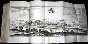
Topographiae Galliae oder Beschribung und Contrafaitung deß Mächtigen Königreichs Franckreich Zweyter Theil die ürnehmste und bekantiste Stätte und Plätze in der Provinc Picardiae. Frankfurt: Caspar Merians, 1656. Topographiae Galliae oder Beschribung und Contrafaitung deß Mächtigen Königreichs Franckreich Dritter Theil die ürnehmste und bekantiste Stätte und Plätze in der Provinc Champagne und Brie furstellendt. Frankfurt: Caspar Merians, 1656. Topographiae Galliae oder Beschribung und Contrafaitung deß Mächtigen Königreichs Franckreich VierderTheil die ürnehmste und bekantiste Stätte und Plätze von Burgund Bresse. Niver Nois und Dombes. furstellendt. Frankfurt: Caspar Merians, 1656. 3 parts in one volume. Folio (11 4/8 x 7 4/8 inches). 3 engraved title-pages (that for Picardy laid down). 3 fine folding engraved maps of Picardie, Champagne et Brie, Les Deux Bourgognes, 5 folding panoramas of Mouza and St. Merehould, Tonnere, Charite, Dijon, and Nevers, 86 double-page engraved plates of views and plans (2 loose), and 13 full-pages plates of views and plans (some waterstaining towards the middle of the book). Modern vellum backed 16th-century red and black letterpress paper boards, vellum corners. Edition in German of Parts II, III, and IV, of an eventual 13. Published just as Louis XIV, the Sun King, began his rule and cultural revolution in France, this is the most comprehensive guide to France of the 17th-century. "Until 1661 the real master of France was Cardinal Mazarin, under whose government his country, victorious over Austria (1643-48) and Spain (1643-59), acquired by the Treaties of Westphalia (1648) and the Pyrennes (1659) Alsace, Artois, and Roussillon, which had already been occupied by French troops since the days of Richelieu. As a result of the marriage between Louis XIV and Maria Theresa of Austria, Louis XIV also acquired rights over the Low Countries. When Louis's personal government began (1661), France was the arbiter of Europe: she had re-established peace among the Powers of the North (Sweden, Brandenburg, Denmark, and Poland); she protected the League of the Rhine; and her authority in Germany was greater than the emperor's. At that period the power of France, established upon the firmest foundations, was perhaps less imposing, but was assuredly more solid, than it became during the most glorious days of Louis XIV's personal government' (Catholic Encyclopedia online). Matthaeus Merian was a notable Swiss engraver born in 1593 in Basel. He learned copperplate engraving in Zurich, though he studied later in Strasbourg, Nancy and Paris. He returned to Basel in 1615, moving to Frankfurt 1616. There he worked for Johann Theodor de Bry, the celebrated publisher whose daughter, Maria Magdelana he married in 1617. In 1620 he and his family moved back to Basel, though they returned to Frankfurt in 1623. After his death in 1650, Mathaeus' sons, Mathaeus and Caspar continued his monumental "Topographia" series of Europe. Shirley G-Meri 22a. Catalogued by Kate Hunter. N° de ref. del artículo 72lib1214
Contactar al vendedor
Denunciar este artículo
Detalles bibliográficos
Título: Topographiae Galliae,. [Parts II,III, and IV...
Editorial: Frankfurt: Caspar Merians, 1656.
Encuadernación: Encuadernación de tapa dura
![]()

