Descripción
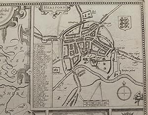
Single sheet (15 x 20 inches) Full margins showing the plate mark (slight browning to edge, good margins) An elaborately decorated and uncolored 1676 edition map of Herefordshire; taken from the Theatre of the Empire of Great Britaine by famous English cartographer John Speed. Engraved by Jocodus Hondius in his Amsterdam workshop in 1610, this map demonstrates the highest level of accuracy, detail, and craftsmanship. This map is particualrily interesting for depicting two cartographers in the lower corners - one holds a globe, the other a pair of dividers. It is assumed that these are the significant individuals tied to the art of mapmaking. Herefordshire is a historic English county in the West Midlands. It's borders touch with those of Shropshire, Worchestershire, Glochestershire, Mounmothshire, and Breknokshire. The landscape of the county is relatively flat; save for a handful of small hills sprinkled around. The town plan of Hereford is found in the right corner. The plan is decorated with the town's coat of arms and a compass rose. Hereford is known as a cathedral city, civil parish, and the county town of Herefordshire; which can be told from the map. The famous Hereford Cathedral, dating back to 1079, sits gallantly in the center of the plan; with a spider web of roads extending from it. Other significant buildings and places are marked by a letter and key guide. It is noteworthy to mention is that this plan was mapped by John Speed himself, as indicated by the 'Scale of Pases' and dividers. A highly sought after feature of Speed's county maps are his inclusions of vignettes showing great English battles and events. The Herefordshire map bears a moment in action of the Battle of Mortimer's Cross in 1461. During the War of the Roses, Owen Tudor, the defeated Lancastrian leader, was taken to Hereford by Sir Roger Vaughan to be executed. As dawn broke, the meteorological phenomenon known as 'parhelion' occurred: three suns were seen to be rising. Edward of York appeared to have convinced the troops that it represented the Holy Trinity and that therefore God was on their side. This event is further articulated in a small frame beneath the vignette. The left side of the map also boasts several coat of arms of the county's ruling Earls and Dukes. The 'Earl of Hereford' is considered one of the first English peerage titles. Notable individuals include: Henry Bullingbrok, 1st Duke of Hereford (1367) and future King Henry IV; William FitzOsbern, 1st Earl of Hereford (1067) and close counselor to William the Conqueror; and Henry Bohun, 1st Earl of Hereford (1199). The county maps found in the Theatre of the Empire of Great Britaine were the first consistent attempt to show territorial divisions, but it was mainly Speed's town plans that were the major innovation and probably his greatest contribution to British cartography. Together, they formed the first printed collection of town plans of the British Isles and, for at least 50 of the 73 included in the Theatre, it was the first time these towns had been mapped. While being the first English atlas of the British Isles, Speed's Atlas was also one of the first attempts to accurately survey Ireland and to incorporate a comprehensive list of their town plans into the maps. The 1676 edition of Speed's atlas never came with original color. The examples of this map of Herefordshire should always be uncolored and never colored. Born in Cheshire, John Speed developed his interest in maps in the 1580s, after moving to London to pursue his passions outside of tailoring. He there joined the Society of Antiquaries, where his enthusiasm for cartography won him the attention of William Camden, Robert Cotton, and Sir Fulke Greville. By working with these figures, Speed was able to do a large amount of research for his own work. In 1596, Greville bequeathed Speed with an unlimited allowance to research, and then later write, the Historie of Great Britaine. It was during this project which Speed. N° de ref. del artículo 72NZ35
Contactar al vendedor
Denunciar este artículo
![]()


