Descripción
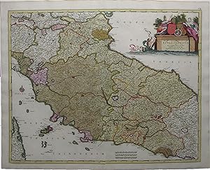
Single sheet, (21 x 24 ½ inches). Fine engraved map of central Italy, surrounded by a border of yellow wash, with EXTREMELY FINE ORIGINAL HAND COLOR IN FULL, HEIGHTENED IN LIQUID GOLD, the individual territories shown in different bold watercolors of yellow, green, and pink, the title within an ELABORATE HISTORIATED CARTOUCHE, and decorated with a fine compass rose pointing north with a GOLD-ENHANCED FLEUR-DE-LIS (old central fold, slightly toned). Beautifully engraved map of central Italy, with original hand color in full and SUMPTUOUS GOLD HIGHLIGHTS. The elegant title cartouche shows two royal figures beside two coats-of-arms with a depiction of the Emperor Constantine at center, and a merman in the blue water below bearing a banner, with two putti looking on. The lovely compass rose is colored red and green with a fleur-de-lis ENHANCED WITH LIQUID GOLD indicating north. The map's title translates to "Papal States and the Grand Duchy of Tuscany." In addition to these, the map shows the Duchy of Ferrara, the island of Elba, and part of Corsica. The Papal States were among the major historical states of Italy from roughly the 6th century until the Italian peninsula was unified in 1861. They saw their greatest extent in the 18th century, when they included most of Central Italy - Lazio, Umbria, Marche, and the Legations of Ravenna, Ferrara, and Bologna extending north into the Romagna. The Grand Duchy of Tuscany was a monarchy in central Italy that replaced the Duchy of Florence in 1569 and ruled for almost 300 years, until 1859. At the time this map was created, Cosimo III de' Medici was the Grand Duke of Tuscany, whose 53-year reign - the longest in Tuscan history - saw much upheaval and decline in the Duchy. De' Medici passed stringent morality laws taxing prostitutes and beheading sodomites, and he censored education and suppressed the Jewish minority. In response to a steep decline in population, he raised taxes exponentially to make up the difference; nevertheless, by 1705 the grand ducal treasury was nearly bankrupt, and the population had dwindled by 40%. The map is extremely detailed, showing the road that leads from Piacenza to Rimini on the Gulf of Venice. The topographical features are rendered pictorially, with the larger cities depicted as fortified citadels. N° de ref. del artículo 72MMS267
Contactar al vendedor
Denunciar este artículo
![]()
