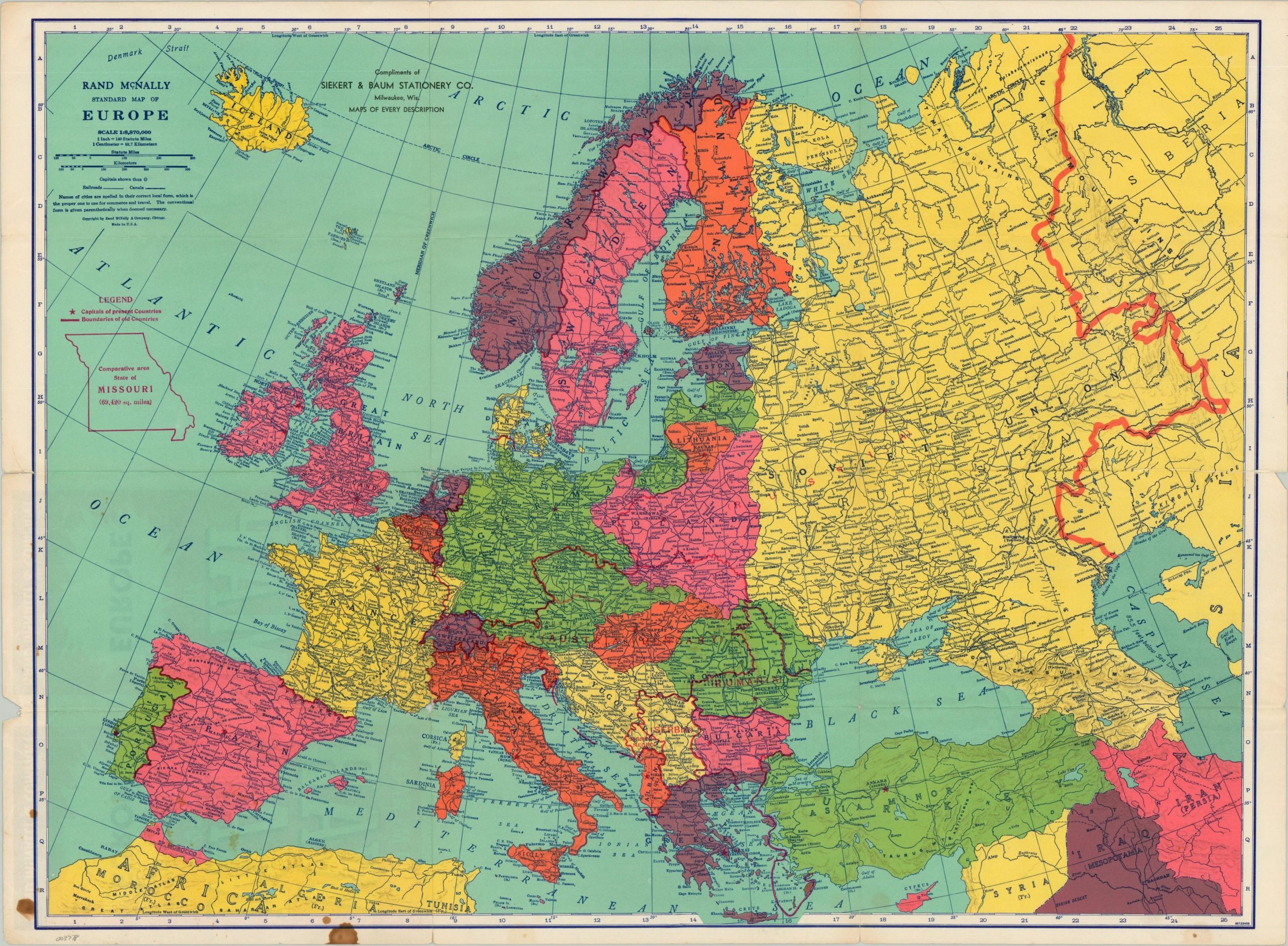
Rand McNally War Map of Europe - An interesting map showing the outbreak of World War II in Europe.
Rand McNally
Editorial: c. 1939, 1939
Usado
Librería:
Curtis Wright Maps, Berwyn, IL, Estados Unidos de America
Calificación del vendedor: 5 de 5 estrellas
![]()
Vendedor de AbeBooks desde 15 de febrero de 2023
Este libro ya no está disponible. Sin embargo, AbeBooks ofrece millones de libros. Escriba otros términos de búsqueda a continuación para encontrar ejemplares similares.
Descripción
Descripción:
This boldly colored map of Europe was published in Chicago by Rand McNally in 1939, shortly after the German invasion of Poland and subsequent declaration of war by France and Britain. Political borders are shaded with vibrant hues and, notably, the territory of the Third Reich includes Austria and the Czech Republic. Also of interest are the former borders of obsolete states like Austria-Hungary shown in red - perhaps a reflection on potential war aims? Last, but not least, an outline of the state of Missouri is provided in the upper left to allow the (largely American) audience to have a better comprehension of the distances involved across the theater. Sheet Width (in) 26.4 Sheet Height (in) 19.4 Condition Description "Creased and lightly worn along former fold lines. About 3" of separation has been repaired on the verso with archival tape and there's a few scattered stains in the lower left.". N° de ref. del artículo 3778
Detalles bibliográficos
Título: Rand McNally War Map of Europe - An ...
Editorial: c. 1939
Ańo de publicación: 1939
Condición: Very Good
IberLibro.com es un mercado online donde puede comprar millones de libros antiguos, nuevos, usados, raros y agotados. Le ponemos en contacto con miles de librerías de todo el mundo. Comprar en IberLibro es fácil y 100% seguro. Busque un libro, realice el pedido a través de nuestra página con toda confianza y recíbalo directamente de la librería.
Busque entre millones de libros de miles de librerías
Libros usados

Bestsellers rebajados, autores destacados y una gran variedad de libros por menos de 5 €. Si su pasatiempo es leer, éste es su espacio.
Libros antiguos y de colección
Compendio vital para el amante del libro antiguo: libros firmados, primeras ediciones, facsímiles, librerías anticuarias o destacados.
Libros con envío gratis
Gastos de envío gratuitos para miles de libros nuevos, antiguos y de ocasión. Sin compra mínima.