


Plan de Paris
Karasz, Ilonka
Editorial: Washington Square Bookshop, New York, 1927
Usado
/
Hardcover /
Cantidad disponible: 0
Librería: James Cummins Bookseller, ABAA (New York, NY, Estados Unidos de America)
Disponible en otras librerías
Ver todos los ejemplares de este libro
Sobre el libro
Lamentablemente este ejemplar en específico ya no está disponible. A continuación, le mostramos una lista de copias similares de Plan de Paris y Karasz, Ilonka.
Descripción:
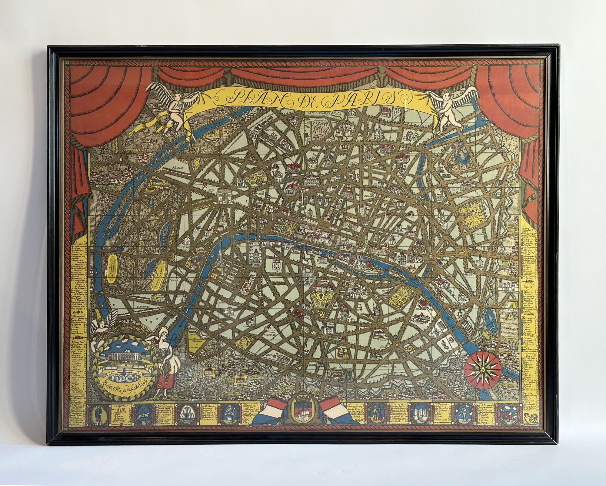
Map printed in colors, heightened with gilt, on thick paper stock, with legend listing monuments, train stations, art galleries, bookstores, banks, bars, hotels, etc. 27-1/2 x 36 inches. A rare and evocative map of the post-WW I Paris of Hemingway, Fitzgerald and Joyce, by the Hungarian-born artist, designer and illustrator Ilonka Karasz (1896-1981) for the Washington Square Bookshop which is identified on the lower margin. The legend lists bookstores, including Brentano's and Shakespeare and Co. Karasz moved to New York in 1913, settling in Greenwich Village, and quickly established herself as a leading practitioner of modern art and design. She worked across a variety of media, including designs for 186 covers of The New Yorker2/19 art. Map printed in colors, heightened with gilt, on thick paper stock, with legend listing monuments, train stations, art galleries, bookstores, banks, bars, hotels, etc. 27-1/2 x 36 inches. N° de ref. del artículo 267674
Detalles bibliográficos
Título: Plan de Paris
Editorial: Washington Square Bookshop, New York
Ańo de publicación: 1927
Encuadernación: Hardcover
Condición: Framed
Los mejores resultados en AbeBooks
1. Plan de Paris Bold pictorial map of Paris with vibrant gold accents.
Antiguo o usado
Cantidad disponible: 1
Librería:
Valoración
Descripción Condición: Very Good. "This beautiful map of the heart of Paris was drawn by the Hungarian-born artist Ilonka Karasz. Karasz moved to the United States in 1913, where she established herself as an artist in Greenwich Village in New York. She worked with a variety of media and her creations incorporated maps in a number of interesting ways, though she was by no means a professional cartographer, as might be inferred from the skill and artistry depicted here. According to the David Rumsey Collection; "Karasz's design and the vivid color printing used for this map of Paris are especially unusual and striking. All of the principal avenues of the City are clearly depicted and appear heightened with gold color finish that enhances the sense of decorative "old style" luxuriance that pervades the whole composition. Title cartouche includes two winged cherubs hold a banner title top center whilst a pair of red curtains are drawn back to reveal a detailed plan of the City of Paris. Map extending from Montmatre in the North to Chatillon, Bvd Jourdan and the vestiges of the southern City walls in the south, to Nanterre and Courbevoie in the West and Vincennes in the East, All of the major parks and gardens of the City and its immediate environs are equally attractively delineated with their trees and principal features. Shows historic sites and buildings in detailed three dimensional vignettes. A roundel inset lower left shows Marie Antoinette as a bucolic shepherdess beside a fine view of the gardens and facade of the Chateau of Versailles, and compass rose on the lower right. Index panels to the left and right sides of the map as well as the bottom denote the principal monuments, museums, churches, and sites of historic interest, as well as shops, bookshops, art galleries, banks, bars and restaurants. The lower border of panels showing historical scenes." Sheet Width (in) 36.4 Sheet Height (in) 27.9 Condition Description Professionally mounted on linen for preservation and stability. Wear and separation along former fold lines remains visible, along with holes at the seam intersections and several chips in the paper around the outer edges. Most affected in the lower left corner. Nş de ref. del artículo: 3079
Comprar usado
EUR 483,87
Convertir moneda