Descripción
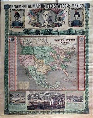
ENSIGN & THAYER. Ornamental Map of the United States & Mexico. New York: Ensign & Thayer, 1848. Lithograph map, with full original hand color, sheet dimensions: 31 x 23 inches (excellent condition, edges reinforced, slight chipping on top right edge). Created at a time of incredible expansion for the nation, this map boldly proclaims in no uncertain terms that America is poised to emerge as a dominant global force. 1848 was a pivotal year that saw the U.S. on the cusp of victory in the Mexican American War, which ended with Mexico being forced to cede almost half of her territory at the Treaty of Guadalupe Hidalgo on the 4th of July of that year. Texas had become a state in 1845, and California, as well as the area to the north which would become Oregon and Washington State were being recognized as U.S. Territories. This sudden addition of land was the first major expansion of the country since the Louisiana Purchase and began the great migration to the west and southwest that continues to this day. Portraits of Generals Zachary Taylor and Winfield Scott-two heroes of the war with Mexico-flank a central image of a mythic-looking and approving George Washington framed in flags and sunbeams. At the base of the sheet, two scenes depict an ancient Mexican culture that has just be defeated by the upstart American conquerors. The "Panoramic View from New York to the Pacific Ocean by the Contemplated Oregon Railroad", located between the map and the top register, is a highly stylized cross-section of the newly transcontinental America. This pictorial expression of 'Manifest Destiny' anticipates the construction of a transnational railway more than twenty years before such an ambition was realized. In "An American Exhibiting to the Sovereigns of Europe the Progress of his country" a healthy Walt Whitman-looking figure in fashionable and casual dress stands on the battlement of a fort bristling with cannon, confidently gesturing to a vista depicting scenes that embody the virtues of America's natural resources and the ingenuity of her people. The European dignitaries are outfitted in stuffy formal garb and look sallow, old, paunched, and intimidated. The landscape features a crowded river filled with steam and sailing ships, rich farmlands dotting lush fields, and bold cloud-piercing mountains surmounted only by an ultra-modern balloon rising in the sky. This juxtaposition was meant to highlight the difference between the Old world and the New, with America as the leaders of the future-a message that the readers of that time must have heard loud and clear. This patriotic tableau, richly ornamented, was the ultimate statement that the popular notion of 'Manifest Destiny' was being fulfilled in the west. In the map of the United States and Mexico, which makes up the centerpiece of the tableau, the United States is shown to extend from sea to sea. Her new possessions include the vast new territory of 'New California', occupying all of the modern states of California, Nevada, Utah, and most of Arizona. New Mexico runs down the length of the upper Rio Grande, while an enlarged Texas (which became a U.S. state in 1845), prominently occupies the center of the map. Also featured is the Oregon Territory, in the Pacific Northwest, which officially became part of the U.S. in 1846, while the vast 'Missouri Territory' and the 'Indian Territory' (the latter still reserved for Native Americans) occupy most the Great Plains. References: Wheat, 'California Gold Fields', no.38; Wheat 'Mapping the Transmississippi West', no. 557. Location note: Texas drawer. N° de ref. del artículo 72GM07
Contactar al vendedor
Denunciar este artículo
![]()

