Descripción
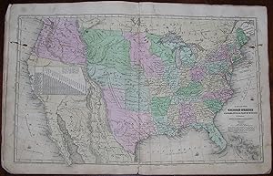
4to., (12 ½ x 9 ½ inches). 23 fine engraved maps with original hand-color in full (some offsetting and spotting, slightly toned). Original publisher's printed pictorial paper wrappers (backstrip worn but holding, edges worn with some loss, a bit browned). Provenance: Contemporary manuscript ownership inscription and pen trials of "Charles N. Howland / Lisle Broome Co. NY / 1849." Later revised edition, first published in 1829. With five maps (including the world map) showing Texas as an independent Republic, with its border along the Rio Grande del Norte. The double-page map of the United States shows an enlarged Iowa, the Mandan District (between Iowa and Oregon Territory), and the Mexico border along the Rockies. When Olney's "New and Improved School Atlas" was first published, "it was immediately successful. The study of geography had but recently been introduced into American elementary education and was still a tail to the cosmographical kite. Its texts were dull and uninteresting, quite beyond the comprehension of elementary school students. Olney's book was suited to his pupils. Beginning with the simple and known facts of their immediate surroundings, it carried them forward to a knowledge of distant lands and complex phenomena. Rudimental as the method seems now, it was new at the time. The book passed through nearly a hundred editions and millions of copies were sold. There were few American school children of that generation whose ideas of the outer world, both true and false, were not formed by it" (Caryn Hannan, ed., "Connecticut Biographical Dictionary," p. 423). N° de ref. del artículo 72MMS179
Contactar al vendedor
Denunciar este artículo
![]()


