Descripción
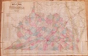
VIRGINIA. Lloyd's Official Map of the State of Virginia from Actual Surveys by Order of the Executive 1828 & 1859, Corrected and Revised by J.T. Lloyd to 1862, from Surveys made by Capt. W. Angelo Powell, of the U.S. Topographical Engineers of Gen. Rosecrans' Staff. N.B. This is the only map used to Plan campaigns in Virginia by Gen. McClellan. New York: Wynkoop & Hallenbeck, 1872 Folding lithographed map (31 x 48 inches), of Virginia, with individual counties alternately coloured (some short tears). The so-called "Lynchburg Edition," issued in 1872, with a large red stencilled star at Lynchburg and the names and routes of the R & L Railroad, the C & O, the L & D, and other railroads shown in red, depicted in radiating out from Lynchburg, making it the center of Virginia's transportation grid. To the left of the image is a text panel describing the Tidewater, Piedmont, and Great Valley regions of the state. The panel to the lower right includes "Steamboat Routes" and "Altitudes of Mountains, &c., in Virginia, above the Tide Water." Before the Civil War, Alexandria built the Orange and Alexandria (O&A) railroad to connect to the farms in the upper Rappahannock River watershed in the Piedmont region. "Alexandria intercepted the trade in wheat and other products that might have gone down the Rappahannock River to Fredericksburg. Alexandria then built the Manassas Gap railroad through the Blue Ridge at Manassas Gap, expanding its railroad connections into the Shenandoah Valley. At Front Royal, rafts and boats bringing iron "pigs," lumber, and farm products on the Shenandoah River could shift their goods to the Manassas Gap railroad, rather than float further downstream to Harpers Ferry, the C&O Canal, and ultimately Georgetown. "The recession or "financial panic" in 1857 forced Alexandria merchants to truncate plans to build a more-expensive Manassas Gap line. The original design was to build an independent, second track roughly parallel to the Orange and Alexandria (O&A) from Alexandria to Manassas, before turning west to cross the Blue Ridge. "Without the financing after the recession, the Manassas Gap rail line was joined to the Orange and Alexandria at an insignifiant location. That rail junction, known as Manassas, became the focal point of the Union Army in 1861. Union generals planned to use the rail line to haul hay and other supplies for the army, as it marched "On to Richmond" in the first major military campaign of the Civil War. "Prior to 1861, the General Assembly of Virginia authorized railroad lines that would steer trade from the Piedmont,Valley and Ridge provinces to a favored Fall Line port - and blocked most proposed railroad extensions that would have directed Shenandoah Valley trade to an out-of-state port. Multiple rail lines were authorized to cross the Blue Ridge and link Alexandria and Richmond with the Shenandoah Valley, but the Baltimore and Ohio (B&O) railroad was blocked from building south from Harpers Ferry, except for a short extension to Winchester. "At Harpers Ferry, trains went over a 900-foot long viaduct above the Potomac River, then used the Baltimore and Ohio (B&O) railroad to carry Virginia-grown farm products to market at Baltimore. The Winchester and Potomac railroad found few manufactured items or other goods to load at Harpers Ferry for the back haul, so it agreed to carry "plaster" (lime fertilizer) for free. The plaster was used to increase fertility of wheat fields in the Shenandoah Valley, ultimately generating more flour/wheat for the railroad to haul to Harpers Ferry, but the railroad depended upon one-way travel from farm to market. "Prior to 1881, Staunton could ship directly to Richmond and Front Royal could ship directly to Alexandria - but those cities had no rail connection to Winchester. The Strasburg-Winchester rail gap, maintained by a General Assembly unwilling to charter a railroad link until after the Civil War, ensured most of the valley did not have a railroad connect. N° de ref. del artículo 72map331
Contactar al vendedor
Denunciar este artículo
![]()
