Descripción
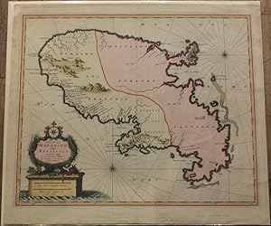
VISSCHER, Nicolaes (1618-1679). Insula Matanino vulgo Martanico. Amsterdam: Nicolaum Visscher, [after 1683]. Single sheet (20 6/8 x 24 inches, full margins showing the plate mark). AN EXCEPTIONALLY FINE ENGRAVED MAP OF THE ISLAND OF MARTINQUE, with original hand-colour if full, HEIGHTENED IN GOLD, the title within an elaborate allegorical cartouche lower left, two compass roses and rhumb lines (central vertical crease, with original mounting guard on verso). A magnificent, large scale map, and beautiful map from one of a series of large atlases compiled and sold by the Visscher family of art dealers and cartographers, who were among the leading producers of maps in Amsterdam at the end of the seventeenth and early eighteenth centuries, founded by Nicholas Visscher, whose work is known for the high quality of engraving, exceptionally fine ornament, and accurate geographical information. Visscher depicts the island of Martinique, which he roughly divides into two distinct halves, with the west coast being colonized by the French, and the eastern coast inhabited by savages!. N° de ref. del artículo 72map377
Contactar al vendedor
Denunciar este artículo
![]()
